![](/images/other/stat-length.png)
![Tocht Stappen Isola - Pas de Ste Anne Hiver - Photo](https://media.geolcdn.com/t/1900/400/11df40ab-3e6f-49e5-8a21-6a9fb61d52d5.jpg&format=pjpeg&maxdim=2)
Pas de Ste Anne Hiver
bozo1970
Gebruiker
![Lengte](/images/other/stat-length.png)
Lengte
6,8 km
![Max. hoogte](https://static1.geolcdn.com/siteimages/upload/files/1508320355ic_sort_altitude_max_24dp.png)
Max. hoogte
2291 m
![Positief hoogteverschil](https://static1.geolcdn.com/siteimages/upload/files/1508320355ic_sort_den_pos_24dp.png)
Positief hoogteverschil
625 m
![Km-Effort](/images/other/stat-length.png)
Km-Effort
15,1 km
![Min. hoogte](https://static1.geolcdn.com/siteimages/upload/files/1508320355ic_sort_altitude_min_24dp.png)
Min. hoogte
1655 m
![Negatief hoogteverschil](https://static1.geolcdn.com/siteimages/upload/files/1508320355ic_sort_den_neg_24dp.png)
Negatief hoogteverschil
628 m
![Boucle](https://static1.geolcdn.com/siteimages/upload/files/16400158638029165_repeat_loop_refresh_sync_direction_icon.png)
Boucle
Ja
Datum van aanmaak :
2024-01-01 09:38:39.0
Laatste wijziging :
2024-01-02 07:06:08.967
![Stappen](https://static1.geolcdn.com/sitytour/trail-icons/101.png)
3h07
Moeilijkheid : Medium
![Scan deze QR-code om de tocht te openen in de SityTrail-applicatie](https://capi.geolives.com/qq0zvz2zws4bq2lad0pu/sitytour/trails/3905681/qr.png?size=200)
Gratisgps-wandelapplicatie
Over ons
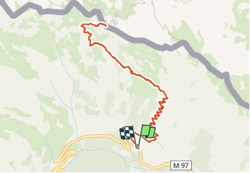
Tocht Stappen van 6,8 km beschikbaar op Provence-Alpes-Côte d'Azur, Alpes-Maritimes, Isola. Deze tocht wordt voorgesteld door bozo1970.
Beschrijving
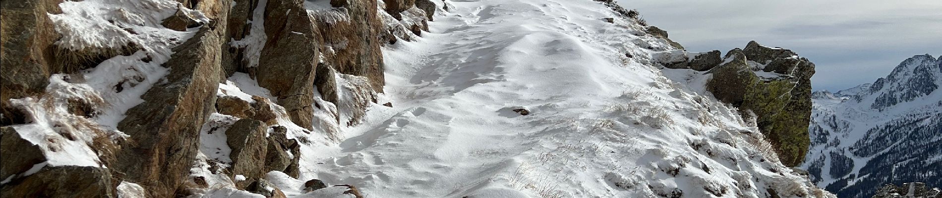
Montée depuis la route à l'oratoire Ste Anne
neige tombée la veille 5cm en bas
Pas de Ste Anne en 1h45'
15cm de neige en haut
Chamois
Toujours aussi grandiose surtout avec la neige
Plaatsbepaling
Land:
France
Regio :
Provence-Alpes-Côte d'Azur
Departement/Provincie :
Alpes-Maritimes
Gemeente :
Isola
Locatie:
Unknown
Vertrek:(Dec)
Vertrek:(UTM)
348859 ; 4896778 (32T) N.
Opmerkingen
Wandeltochten in de omgeving
![Tocht Stappen Isola - Châtaigneraie ISOLA - Photo](https://media.geolcdn.com/t/375/260/ext.jpg?maxdim=2&url=https%3A%2F%2Fservices.sitytrail.com%2FGeolivesWS%2FDownloadMedia.ashx%3FTrailID%3D470503%26Media%3D20150910120215.jpg)
![Stappen Stappen](https://static1.geolcdn.com/sitytour/trail-icons/101.png)
Châtaigneraie ISOLA
Stappen
Heel gemakkelijk
(1)
Isola,
Provence-Alpes-Côte d'Azur,
Alpes-Maritimes,
France
![](/images/other/stat-length.png)
4,4 km | 7,1 km-effort
2h 9min
![](https://static1.geolcdn.com/siteimages/upload/files/16400158638029165_repeat_loop_refresh_sync_direction_icon.png)
Ja
![Tocht Andere activiteiten Isola - Isola 2000 baisse Druos refuge Quesa - Photo](https://media.geolcdn.com/t/375/260/ext.jpg?maxdim=2&url=https%3A%2F%2Fservices.sitytrail.com%2FGeolivesWS%2FDownloadMedia.ashx%3FTrailID%3D631831%26Media%3Dfix__20160806152443.jpg)
![Andere activiteiten Andere activiteiten](https://static1.geolcdn.com/sitytour/trail-icons/900.png)
Isola 2000 baisse Druos refuge Quesa
Andere activiteiten
Heel gemakkelijk
(1)
Isola,
Provence-Alpes-Côte d'Azur,
Alpes-Maritimes,
France
![](/images/other/stat-length.png)
21 km | 35 km-effort
8h 5min
![](https://static1.geolcdn.com/siteimages/upload/files/16400158638029165_repeat_loop_refresh_sync_direction_icon.png)
Ja
![Tocht Stappen Isola - Tête Mercière et Lacs de terre rouge 24.8.24 - Photo](https://media.geolcdn.com/t/375/260/3e3a1aaf-e381-4ca9-a18c-df28b1091979.jpg&format=jpg&maxdim=2)
![Stappen Stappen](https://static1.geolcdn.com/sitytour/trail-icons/101.png)
Tête Mercière et Lacs de terre rouge 24.8.24
Stappen
Medium
Isola,
Provence-Alpes-Côte d'Azur,
Alpes-Maritimes,
France
![](/images/other/stat-length.png)
11,6 km | 18 km-effort
4h 0min
![](https://static1.geolcdn.com/siteimages/upload/files/16400158638029165_repeat_loop_refresh_sync_direction_icon.png)
Neen
![Tocht Te voet Isola - Tête Mercière - Photo](https://media.geolcdn.com/t/375/260/8e1ca2e5-a446-45a1-b4b9-1747f6caafe0.jpeg&format=jpg&maxdim=2)
![Te voet Te voet](https://static1.geolcdn.com/sitytour/trail-icons/100.png)
Tête Mercière
Te voet
Gemakkelijk
Isola,
Provence-Alpes-Côte d'Azur,
Alpes-Maritimes,
France
![](/images/other/stat-length.png)
8,1 km | 14,8 km-effort
3h 21min
![](https://static1.geolcdn.com/siteimages/upload/files/16400158638029165_repeat_loop_refresh_sync_direction_icon.png)
Neen
![Tocht Te voet Vinadio - Tour du Lausfer - Photo](https://media.geolcdn.com/t/375/260/cc4c2b4d-e173-4a84-be7d-4686c9701dd6.jpeg&format=jpg&maxdim=2)
![Te voet Te voet](https://static1.geolcdn.com/sitytour/trail-icons/100.png)
Tour du Lausfer
Te voet
Gemakkelijk
Vinadio,
Piëmont,
Cuneo,
Italy
![](/images/other/stat-length.png)
9,5 km | 16,7 km-effort
3h 47min
![](https://static1.geolcdn.com/siteimages/upload/files/16400158638029165_repeat_loop_refresh_sync_direction_icon.png)
Ja
![Tocht Te voet Vinadio - (SI E13) Sant'Anna di Vinadio - Vinadio Frazione Strepeis - Photo](https://media.geolcdn.com/t/375/260/2964e30b-263b-42c3-aa1c-ecaafebd0df1.jpeg&format=jpg&maxdim=2)
![Te voet Te voet](https://static1.geolcdn.com/sitytour/trail-icons/100.png)
(SI E13) Sant'Anna di Vinadio - Vinadio Frazione Strepeis
Te voet
Gemakkelijk
Vinadio,
Piëmont,
Cuneo,
Italy
![](/images/other/stat-length.png)
9,1 km | 16,1 km-effort
3h 40min
![](https://static1.geolcdn.com/siteimages/upload/files/16400158638029165_repeat_loop_refresh_sync_direction_icon.png)
Neen
![Tocht Stappen Isola - cime de la lombarde - Photo](https://media.geolcdn.com/t/375/260/ext.jpg?maxdim=2&url=https%3A%2F%2Fstatic1.geolcdn.com%2Fsiteimages%2Fupload%2Ffiles%2F1553511878bg_sport_marche.png)
![Stappen Stappen](https://static1.geolcdn.com/sitytour/trail-icons/101.png)
cime de la lombarde
Stappen
Zeer moeilijk
(1)
Isola,
Provence-Alpes-Côte d'Azur,
Alpes-Maritimes,
France
![](/images/other/stat-length.png)
16,7 km | 31 km-effort
9h 25min
![](https://static1.geolcdn.com/siteimages/upload/files/16400158638029165_repeat_loop_refresh_sync_direction_icon.png)
Ja
![Tocht Stappen Vinadio - Cime de la Lombarde 2800m 26.8.24 - Photo](https://media.geolcdn.com/t/375/260/a90fbc15-b832-4be5-b4ba-c6dcb34efb02.jpg&format=jpg&maxdim=2)
![Stappen Stappen](https://static1.geolcdn.com/sitytour/trail-icons/101.png)
Cime de la Lombarde 2800m 26.8.24
Stappen
Zeer moeilijk
Vinadio,
Piëmont,
Cuneo,
Italy
![](/images/other/stat-length.png)
3,4 km | 9,1 km-effort
2h 30min
![](https://static1.geolcdn.com/siteimages/upload/files/16400158638029165_repeat_loop_refresh_sync_direction_icon.png)
Ja
![Tocht Stappen Vinadio - Tour du Lausfer 25.8.24 - Photo](https://media.geolcdn.com/t/375/260/72863bea-5e16-4036-8653-9180a45481ca.jpg&format=jpg&maxdim=2)
![Stappen Stappen](https://static1.geolcdn.com/sitytour/trail-icons/101.png)
Tour du Lausfer 25.8.24
Stappen
Medium
Vinadio,
Piëmont,
Cuneo,
Italy
![](/images/other/stat-length.png)
9 km | 16,2 km-effort
3h 30min
![](https://static1.geolcdn.com/siteimages/upload/files/16400158638029165_repeat_loop_refresh_sync_direction_icon.png)
Ja