![](/images/other/stat-length.png)
![Tocht Stappen Montivilliers - Montivilliers départ de la piscine - Photo](https://media.geolcdn.com/t/1900/400/ext.pjpeg?maxdim=2&url=https%3A%2F%2Fstatic1.geolcdn.com%2Fsiteimages%2Fupload%2Ffiles%2F1553511878bg_sport_marche.png)
Montivilliers départ de la piscine
AACLARANDO
Gebruiker
![Lengte](/images/other/stat-length.png)
Lengte
9,8 km
![Max. hoogte](https://static1.geolcdn.com/siteimages/upload/files/1508320355ic_sort_altitude_max_24dp.png)
Max. hoogte
103 m
![Positief hoogteverschil](https://static1.geolcdn.com/siteimages/upload/files/1508320355ic_sort_den_pos_24dp.png)
Positief hoogteverschil
149 m
![Km-Effort](/images/other/stat-length.png)
Km-Effort
11,7 km
![Min. hoogte](https://static1.geolcdn.com/siteimages/upload/files/1508320355ic_sort_altitude_min_24dp.png)
Min. hoogte
21 m
![Negatief hoogteverschil](https://static1.geolcdn.com/siteimages/upload/files/1508320355ic_sort_den_neg_24dp.png)
Negatief hoogteverschil
149 m
![Boucle](https://static1.geolcdn.com/siteimages/upload/files/16400158638029165_repeat_loop_refresh_sync_direction_icon.png)
Boucle
Ja
Datum van aanmaak :
2023-12-29 13:28:11.456
Laatste wijziging :
2023-12-29 15:45:29.036
![Stappen](https://static1.geolcdn.com/sitytour/trail-icons/101.png)
2h16
Moeilijkheid : Medium
![Scan deze QR-code om de tocht te openen in de SityTrail-applicatie](https://capi.geolives.com/qq0zvz2zws4bq2lad0pu/sitytour/trails/3903889/qr.png?size=200)
Gratisgps-wandelapplicatie
Over ons
Tocht Stappen van 9,8 km beschikbaar op Normandië, Seine-Maritime, Montivilliers. Deze tocht wordt voorgesteld door AACLARANDO.
Beschrijving
boucle de Montivilliers par le Fontenay et rolleville avec passage délicat dans le vallon de la clinnarderie causes ornières profondes.
Plaatsbepaling
Land:
France
Regio :
Normandië
Departement/Provincie :
Seine-Maritime
Gemeente :
Montivilliers
Locatie:
Unknown
Vertrek:(Dec)
Vertrek:(UTM)
295592 ; 5492616 (31U) N.
Opmerkingen
Wandeltochten in de omgeving
![Tocht Stappen Harfleur - Turner's walk - Photo](https://media.geolcdn.com/t/375/260/ext.jpg?maxdim=2&url=https%3A%2F%2Fservices.sitytrail.com%2FGeolivesWS%2FDownloadMedia.ashx%3FTrailID%3D338140%26Media%3D38869f3e-a905-416b-990a-9713f7dd7e14.jpg)
![Stappen Stappen](https://static1.geolcdn.com/sitytour/trail-icons/101.png)
Turner's walk
Stappen
Gemakkelijk
(1)
Harfleur,
Normandië,
Seine-Maritime,
France
![](/images/other/stat-length.png)
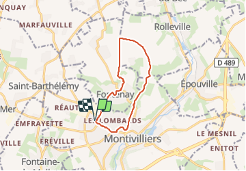
7,7 km | 9,1 km-effort
3h 0min
![](https://static1.geolcdn.com/siteimages/upload/files/16400158638029165_repeat_loop_refresh_sync_direction_icon.png)
Ja
![Tocht Stappen Saint-Martin-du-Manoir - st Martin - st Laurent - Photo](https://media.geolcdn.com/t/375/260/ext.jpg?maxdim=2&url=https%3A%2F%2Fstatic1.geolcdn.com%2Fsiteimages%2Fupload%2Ffiles%2F1553511878bg_sport_marche.png)
![Stappen Stappen](https://static1.geolcdn.com/sitytour/trail-icons/101.png)
st Martin - st Laurent
Stappen
Moeilijk
(1)
Saint-Martin-du-Manoir,
Normandië,
Seine-Maritime,
France
![](/images/other/stat-length.png)
10,6 km | 12,7 km-effort
2h 52min
![](https://static1.geolcdn.com/siteimages/upload/files/16400158638029165_repeat_loop_refresh_sync_direction_icon.png)
Ja
![Tocht Stappen Épouville - epouville 7,8 - Photo](https://media.geolcdn.com/t/375/260/ext.jpg?maxdim=2&url=https%3A%2F%2Fstatic1.geolcdn.com%2Fsiteimages%2Fupload%2Ffiles%2F1553511878bg_sport_marche.png)
![Stappen Stappen](https://static1.geolcdn.com/sitytour/trail-icons/101.png)
epouville 7,8
Stappen
Medium
(1)
Épouville,
Normandië,
Seine-Maritime,
France
![](/images/other/stat-length.png)
7,8 km | 9,3 km-effort
2h 6min
![](https://static1.geolcdn.com/siteimages/upload/files/16400158638029165_repeat_loop_refresh_sync_direction_icon.png)
Ja
![Tocht Te voet Fontaine-la-Mallet - Les Bassins des Vallées - Photo](https://media.geolcdn.com/t/375/260/ce57ffe6-f4ea-486c-bc79-47861158f9a7.jpeg&format=jpg&maxdim=2)
![Te voet Te voet](https://static1.geolcdn.com/sitytour/trail-icons/100.png)
Les Bassins des Vallées
Te voet
Gemakkelijk
Fontaine-la-Mallet,
Normandië,
Seine-Maritime,
France
![](/images/other/stat-length.png)
5,1 km | 6 km-effort
1h 21min
![](https://static1.geolcdn.com/siteimages/upload/files/16400158638029165_repeat_loop_refresh_sync_direction_icon.png)
Neen
![Tocht Stappen Épouville - Epouville / Le Gray / La Lézarde /Epouville - Photo](https://media.geolcdn.com/t/375/260/ext.jpg?maxdim=2&url=https%3A%2F%2Fstatic1.geolcdn.com%2Fsiteimages%2Fupload%2Ffiles%2F1553511878bg_sport_marche.png)
![Stappen Stappen](https://static1.geolcdn.com/sitytour/trail-icons/101.png)
Epouville / Le Gray / La Lézarde /Epouville
Stappen
Medium
(1)
Épouville,
Normandië,
Seine-Maritime,
France
![](/images/other/stat-length.png)
8,6 km | 10,3 km-effort
2h 20min
![](https://static1.geolcdn.com/siteimages/upload/files/16400158638029165_repeat_loop_refresh_sync_direction_icon.png)
Ja
![Tocht Te voet Le Havre - Parc de Rouelles - GR - 16-09-2024 - Photo](https://media.geolcdn.com/t/375/260/ext.jpg?maxdim=2&url=https%3A%2F%2Fstatic1.geolcdn.com%2Fsiteimages%2Fupload%2Ffiles%2F1545311037marcheuse_200dpi.jpg)
![Te voet Te voet](https://static1.geolcdn.com/sitytour/trail-icons/100.png)
Parc de Rouelles - GR - 16-09-2024
Te voet
Gemakkelijk
(1)
Le Havre,
Normandië,
Seine-Maritime,
France
![](/images/other/stat-length.png)
9,4 km | 11,6 km-effort
2h 37min
![](https://static1.geolcdn.com/siteimages/upload/files/16400158638029165_repeat_loop_refresh_sync_direction_icon.png)
Ja
![Tocht Stappen Rolleville - 76-Rolleville - Photo](https://media.geolcdn.com/t/375/260/c4a01121-b546-41d9-85a0-a5074e485afa.jpg&format=jpg&maxdim=2)
![Stappen Stappen](https://static1.geolcdn.com/sitytour/trail-icons/101.png)
76-Rolleville
Stappen
Gemakkelijk
Rolleville,
Normandië,
Seine-Maritime,
France
![](/images/other/stat-length.png)
13,2 km | 15,5 km-effort
3h 1min
![](https://static1.geolcdn.com/siteimages/upload/files/16400158638029165_repeat_loop_refresh_sync_direction_icon.png)
Ja
![Tocht Stappen Fontenay - Le Fontenay - 10-07-23 - Circuit court - Photo](https://media.geolcdn.com/t/375/260/ext.jpg?maxdim=2&url=https%3A%2F%2Fstatic1.geolcdn.com%2Fsiteimages%2Fupload%2Ffiles%2F1553511878bg_sport_marche.png)
![Stappen Stappen](https://static1.geolcdn.com/sitytour/trail-icons/101.png)
Le Fontenay - 10-07-23 - Circuit court
Stappen
Medium
(1)
Fontenay,
Normandië,
Seine-Maritime,
France
![](/images/other/stat-length.png)
7,1 km | 8,3 km-effort
1h 53min
![](https://static1.geolcdn.com/siteimages/upload/files/16400158638029165_repeat_loop_refresh_sync_direction_icon.png)
Ja
![Tocht Stappen Fontenay - Le Fontenay - 10-07-23 - Photo](https://media.geolcdn.com/t/375/260/ext.jpg?maxdim=2&url=https%3A%2F%2Fstatic1.geolcdn.com%2Fsiteimages%2Fupload%2Ffiles%2F1553511878bg_sport_marche.png)
![Stappen Stappen](https://static1.geolcdn.com/sitytour/trail-icons/101.png)
Le Fontenay - 10-07-23
Stappen
Medium
(1)
Fontenay,
Normandië,
Seine-Maritime,
France
![](/images/other/stat-length.png)
9,7 km | 11,1 km-effort
2h 31min
![](https://static1.geolcdn.com/siteimages/upload/files/16400158638029165_repeat_loop_refresh_sync_direction_icon.png)
Ja