


2023-12-16_21h44m16_2023-12-16_1393312634_GPX Download_ Blue City Chefchaouen – Tr boucle au départ de Chefchaouen ⵛⴼⵛⴰⵡⵏ شفشاون

Eric Bléreau
Gebruiker
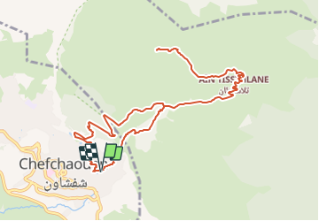

Lengte
14,9 km

Max. hoogte
1598 m

Positief hoogteverschil
1048 m
Km-Effort
29 km

Min. hoogte
610 m

Negatief hoogteverschil
1048 m
Boucle
Ja
Datum van aanmaak :
2023-12-16 20:44:17.831
Laatste wijziging :
2023-12-21 16:20:43.839

Gratisgps-wandelapplicatie
 SityTrail
IGN / Geografische instituten
SityTrail World
De wereld gaat voor u open
Over ons
Tocht van 14,9 km beschikbaar op Tanger-Tétouan-Al Hoceima ⵟⴰⵏⵊ-ⵟⵉⵜⴰⵡⵉⵏ-ⵍⵃⵓⵙⵉⵎⴰ طنجة تطوان الحسيمة, Chefchaouen ⴰⵛⵛⴰⵡⵏ شفشاون. Deze tocht wordt voorgesteld door Eric Bléreau.
Plaatsbepaling
Land:
Morocco
Regio :
Tanger-Tétouan-Al Hoceima ⵟⴰⵏⵊ-ⵟⵉⵜⴰⵡⵉⵏ-ⵍⵃⵓⵙⵉⵎⴰ طنجة تطوان الحسيمة
Departement/Provincie :
Chefchaouen ⴰⵛⵛⴰⵡⵏ شفشاون
Gemeente :
Unknown
Locatie:
Unknown
Vertrek:(Dec)
Vertrek:(UTM)
294101 ; 3894120 (30S) N.
Opmerkingen
Wandeltochten in de omgeving