Tocht Stappen Saint-Marc-la-Lande - Mazières-en-Gâtine 6 chemins - Photo

Mazières-en-Gâtine 6 chemins

© OpenStreetMap contributors
Lengte
Lengte
6,1 km
Max. hoogte
Max. hoogte
223 m
Positief hoogteverschil
50 m
Km-Effort
Km-Effort  
6,8 km
Min. hoogte
Min. hoogte
188 m
Negatief hoogteverschil
52 m
Boucle
Boucle
Ja
Datum van aanmaak :
2023-12-04 13:41:57.264
Laatste wijziging :
2023-12-04 15:11:55.098

(0 Bericht)

Stappen
Stappen
1h21
Moeilijkheid : Heel gemakkelijk

Scan deze QR-code om de tocht te openen in de SityTrail-applicatie

Gratisgps-wandelapplicatie

Logo SityTrail SityTrail

IGN / Geografische instituten

SityTrail uit de App Store downloaden SityTrail uit Google Play downloaden

Logo SityTrail SityTrail World

De wereld gaat voor u open

SityTrail uit de App Store downloaden SityTrail uit Google Play downloaden SityTrail op Huawei AppGallery downloaden

Over ons

Tocht Stappen van 6,1 km beschikbaar op Nieuw-Aquitanië, Deux-Sèvres, Saint-Marc-la-Lande. Deze tocht wordt voorgesteld door Philippe Baraton.

Hoogteprofiel

Foto's

Plaatsbepaling

Land:
France
Regio :
Nieuw-Aquitanië
Departement/Provincie :
Deux-Sèvres
Gemeente :
Saint-Marc-la-Lande
Locatie:
Unknown
Vertrek:(UTM)
705001 ; 5156848 (30T) N.

Wandeltochten in de omgeving

Tocht Stappen Mazières-en-Gâtine - Mazières-en-Gâtine Golf - Photo
Stappen
Philippe Baraton

Stappen

Heel gemakkelijk
Mazières-en-Gâtine, Nieuw-Aquitanië, Deux-Sèvres, France
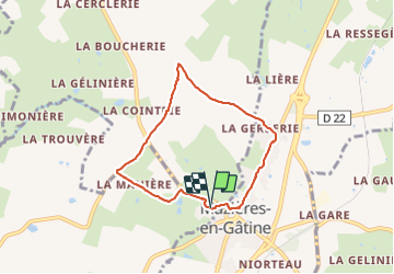
9,4 km | 10,9 km-effort
2h 10min
Ja
Tocht Stappen Saint-Pardoux-Soutiers - St pardoux les croix  - Photo
Stappen
jean louis kozo

Stappen

Saint-Pardoux-Soutiers, Nieuw-Aquitanië, Deux-Sèvres, France
8,7 km | 10,1 km-effort
1h 58min
Ja
Tocht Quad Saint-Pardoux-Soutiers - du 15 - Photo
Quad
favraux

Quad

Heel gemakkelijk
Saint-Pardoux-Soutiers, Nieuw-Aquitanië, Deux-Sèvres, France
76 km | 87 km-effort
8h 41min
Neen
Tocht Stappen Mazières-en-Gâtine - golf - Photo
Stappen
clhote

Stappen

Medium
Mazières-en-Gâtine, Nieuw-Aquitanië, Deux-Sèvres, France
8,1 km | 9,4 km-effort
4h 5min
Neen
Tocht Stappen Verruyes - 2012-12-17T18:42:16Z - Photo
Stappen
Dom4i

Stappen

Zeer moeilijk
Verruyes, Nieuw-Aquitanië, Deux-Sèvres, France
26 km | 31 km-effort
6h 46min
Ja
Tocht Stappen Mazières-en-Gâtine - 79 MAZIERES EN GÂTINE Le Ruisseau de Monbail - Photo
Stappen
maioy

Stappen

Heel gemakkelijk
Mazières-en-Gâtine, Nieuw-Aquitanië, Deux-Sèvres, France
7,3 km | 8,7 km-effort
1h 53min
Ja
Tocht Mountainbike Saint-Pardoux-Soutiers - soutiers2014 - Photo
Mountainbike
STEPHAS

Mountainbike

Gemakkelijk
Saint-Pardoux-Soutiers, Nieuw-Aquitanië, Deux-Sèvres, France
54 km | 64 km-effort
5h 54min
Neen


Sluiten
Mijn abonnementen