![](/images/other/stat-length.png)
![Tocht Stappen Placey - Placeý - Photo](https://media.geolcdn.com/t/1900/400/45ce0320-9354-41df-81be-d3c9152b9365.jpg&format=pjpeg&maxdim=2)
Placeý
eltonnermou
Gebruiker
![Lengte](/images/other/stat-length.png)
![Max. hoogte](https://static1.geolcdn.com/siteimages/upload/files/1508320355ic_sort_altitude_max_24dp.png)
![Positief hoogteverschil](https://static1.geolcdn.com/siteimages/upload/files/1508320355ic_sort_den_pos_24dp.png)
![Km-Effort](/images/other/stat-length.png)
![Min. hoogte](https://static1.geolcdn.com/siteimages/upload/files/1508320355ic_sort_altitude_min_24dp.png)
![Negatief hoogteverschil](https://static1.geolcdn.com/siteimages/upload/files/1508320355ic_sort_den_neg_24dp.png)
![Boucle](https://static1.geolcdn.com/siteimages/upload/files/16400158638029165_repeat_loop_refresh_sync_direction_icon.png)
![Stappen](https://static1.geolcdn.com/sitytour/trail-icons/101.png)
3h57
Moeilijkheid : Gemakkelijk
![Scan deze QR-code om de tocht te openen in de SityTrail-applicatie](https://capi.geolives.com/qq0zvz2zws4bq2lad0pu/sitytour/trails/3877195/qr.png?size=200)
Gratisgps-wandelapplicatie
Over ons
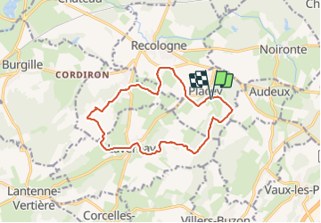
Tocht Stappen van 13,5 km beschikbaar op Bourgondië-Franche-Comté, Doubs, Placey. Deze tocht wordt voorgesteld door eltonnermou.
Beschrijving
randonnée proche de celle intitulée "Lavernay".
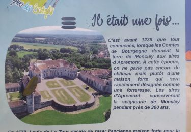
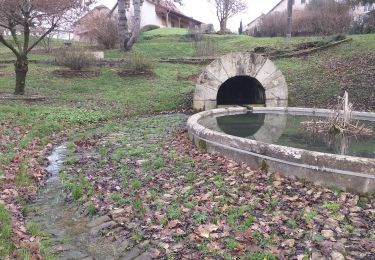
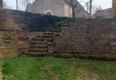
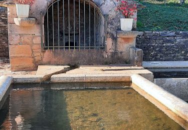
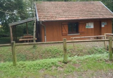
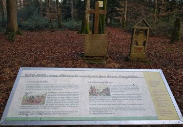
ce parcours pédestre agréable, vous emmènera à travers prairie et villages de la plaine du Doubs. Quelques curiosités (point de vue, bâtisse, fontaines ...) à regarder, observer en parcours, et sur la fin vous pourrez faire le tour de la "motte féodale" avec une explication de la chose.
pour faciliter votre progression (évite une traversée de ronce et puis de barbelé), à environ 5,7km du départ (après Franey et après la fontaine de Vauchon) en arrivant sur ce chemin transversal, partez à droite (et non à gauche), à environ 500m plus loin au croisement partir à gauche, puis laisser un chemin à main droite en poursuivant tout droit, à la pâte d'oie suivante prendre à gauche et rejoindre la trace.
laissez vous surprendre par la faune, et suivant les saisons par la flore.
Plaatsbepaling
Opmerkingen
Wandeltochten in de omgeving
![Tocht Mountainbike Audeux - audeux classik 30 - Photo](https://media.geolcdn.com/t/375/260/ext.jpg?maxdim=2&url=https%3A%2F%2Fstatic1.geolcdn.com%2Fsiteimages%2Fupload%2Ffiles%2F1524743154velo.jpg)
![Mountainbike Mountainbike](https://static1.geolcdn.com/sitytour/trail-icons/202.png)
Mountainbike
![](/images/other/stat-length.png)
![](https://static1.geolcdn.com/siteimages/upload/files/16400158638029165_repeat_loop_refresh_sync_direction_icon.png)
![Tocht Stappen Chemaudin et Vaux - chemin des vignes - Photo](https://media.geolcdn.com/t/375/260/09f8fdc7-9eee-478c-a43b-c779e5a0f3b9.jpg&format=jpg&maxdim=2)
![Stappen Stappen](https://static1.geolcdn.com/sitytour/trail-icons/101.png)
Stappen
![](/images/other/stat-length.png)
![](https://static1.geolcdn.com/siteimages/upload/files/16400158638029165_repeat_loop_refresh_sync_direction_icon.png)
![Tocht Stappen Chaucenne - chaucenne long - Photo](https://media.geolcdn.com/t/375/260/993b8a30-d499-4a28-bada-097339add92d.jpg&format=jpg&maxdim=2)
![Stappen Stappen](https://static1.geolcdn.com/sitytour/trail-icons/101.png)
Stappen
![](/images/other/stat-length.png)
![](https://static1.geolcdn.com/siteimages/upload/files/16400158638029165_repeat_loop_refresh_sync_direction_icon.png)
![Tocht Stappen Chaucenne - chaucen..ne perd rien - Photo](https://media.geolcdn.com/t/375/260/ffef17a3-de4e-4ff1-b440-d69f6c3b1d18.jpg&format=jpg&maxdim=2)
![Stappen Stappen](https://static1.geolcdn.com/sitytour/trail-icons/101.png)
Stappen
![](/images/other/stat-length.png)
![](https://static1.geolcdn.com/siteimages/upload/files/16400158638029165_repeat_loop_refresh_sync_direction_icon.png)
![Tocht Stappen Corcondray - corcondray - Photo](https://media.geolcdn.com/t/375/260/d98283d1-4554-484f-9a27-55a0c4c36ada.jpg&format=jpg&maxdim=2)
![Stappen Stappen](https://static1.geolcdn.com/sitytour/trail-icons/101.png)
Stappen
![](/images/other/stat-length.png)
![](https://static1.geolcdn.com/siteimages/upload/files/16400158638029165_repeat_loop_refresh_sync_direction_icon.png)
![Tocht Stappen Lavernay - Lavernay - Photo](https://media.geolcdn.com/t/375/260/46a3bc05-4f2a-4506-8b21-f4eec38d0f18.jpg&format=jpg&maxdim=2)
![Stappen Stappen](https://static1.geolcdn.com/sitytour/trail-icons/101.png)
Stappen
![](/images/other/stat-length.png)
![](https://static1.geolcdn.com/siteimages/upload/files/16400158638029165_repeat_loop_refresh_sync_direction_icon.png)
![Tocht Stappen Chemaudin et Vaux - Chemaudin et vaux Mazerolles Placey - Photo](https://media.geolcdn.com/t/375/260/52ad3a14-afdc-4518-a4d7-1299944a55e0.jpg&format=jpg&maxdim=2)
![Stappen Stappen](https://static1.geolcdn.com/sitytour/trail-icons/101.png)
Stappen
![](/images/other/stat-length.png)
![](https://static1.geolcdn.com/siteimages/upload/files/16400158638029165_repeat_loop_refresh_sync_direction_icon.png)
![Tocht Stappen Chevigney-sur-l'Ognon - CHEVIGNEY SUR L'OGNON - Photo](https://media.geolcdn.com/t/375/260/57c106b7-78bf-4289-8e4b-16fb41fe85ac.jpg&format=jpg&maxdim=2)
![Stappen Stappen](https://static1.geolcdn.com/sitytour/trail-icons/101.png)
Stappen
![](/images/other/stat-length.png)
![](https://static1.geolcdn.com/siteimages/upload/files/16400158638029165_repeat_loop_refresh_sync_direction_icon.png)
![Tocht Stappen Recologne - Recologne Noironte 4 fév 2020 CAF - Photo](https://media.geolcdn.com/t/375/260/344519ec-337c-4e8c-8eb4-e73f67014531.jpg&format=jpg&maxdim=2)
![Stappen Stappen](https://static1.geolcdn.com/sitytour/trail-icons/101.png)
Stappen
![](/images/other/stat-length.png)
![](https://static1.geolcdn.com/siteimages/upload/files/16400158638029165_repeat_loop_refresh_sync_direction_icon.png)