


Mapuche direct Rio grande

iznogud
Gebruiker
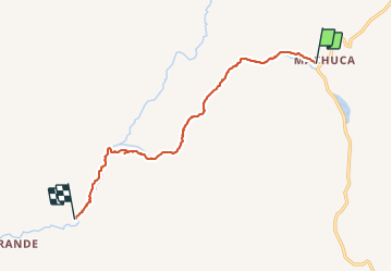

Lengte
14 km

Max. hoogte
4013 m

Positief hoogteverschil
55 m
Km-Effort
17 km

Min. hoogte
3327 m

Negatief hoogteverschil
732 m
Boucle
Neen
Datum van aanmaak :
2023-11-14 14:28:16.0
Laatste wijziging :
2023-11-14 23:35:18.707

Gratisgps-wandelapplicatie
 SityTrail
IGN / Geografische instituten
SityTrail World
De wereld gaat voor u open
Over ons
Tocht van 14 km beschikbaar op Región de Antofagasta, Provincia de El Loa, San Pedro de Atacama. Deze tocht wordt voorgesteld door iznogud.
Beschrijving
Par le torrent difficile
Plaatsbepaling
Land:
Chile
Regio :
Región de Antofagasta
Departement/Provincie :
Provincia de El Loa
Gemeente :
San Pedro de Atacama
Locatie:
Unknown
Vertrek:(Dec)
Vertrek:(UTM)
595928 ; 7500552 (19K) Z.
Opmerkingen
Wandeltochten in de omgeving