


Maroc 01-11-2023

honda400xr
Gebruiker

Lengte
363 km

Max. hoogte
1165 m

Positief hoogteverschil
2072 m
Km-Effort
392 km

Min. hoogte
694 m

Negatief hoogteverschil
2536 m
Boucle
Neen
Datum van aanmaak :
2023-11-01 10:31:29.189
Laatste wijziging :
2023-11-01 17:45:28.785
7h13
Moeilijkheid : Heel gemakkelijk

Gratisgps-wandelapplicatie
 SityTrail
IGN / Geografische instituten
SityTrail World
De wereld gaat voor u open
Over ons
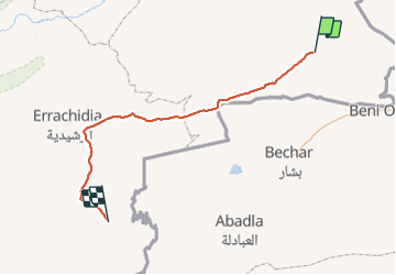
Tocht Trail van 363 km beschikbaar op Oriental ⵜⴰⵏⴳⵎⵓⴹⵜ الشرقية, Pachalik de Bouarfa, Bouarfa بوعرفة. Deze tocht wordt voorgesteld door honda400xr.
Plaatsbepaling
Land:
Morocco
Regio :
Oriental ⵜⴰⵏⴳⵎⵓⴹⵜ الشرقية
Departement/Provincie :
Pachalik de Bouarfa
Gemeente :
Bouarfa بوعرفة
Locatie:
Unknown
Vertrek:(Dec)
Vertrek:(UTM)
597735 ; 3599757 (30S) N.
Opmerkingen
Wandeltochten in de omgeving