


Maroc 30-10-2023

honda400xr
Gebruiker

Lengte
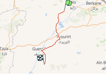
132 km

Max. hoogte
660 m

Positief hoogteverschil
1330 m
Km-Effort
149 km

Min. hoogte
220 m

Negatief hoogteverschil
940 m
Boucle
Neen
Datum van aanmaak :
2023-10-30 11:13:36.432
Laatste wijziging :
2023-10-30 16:47:52.79
2h55
Moeilijkheid : Heel gemakkelijk

Gratisgps-wandelapplicatie
 SityTrail
IGN / Geografische instituten
SityTrail World
De wereld gaat voor u open
Over ons
Tocht Trail van 132 km beschikbaar op Oriental ⵜⴰⵏⴳⵎⵓⴹⵜ الشرقية, Cercle de Louta دائرة الوطا, Hassi Berkane حاسي بركان. Deze tocht wordt voorgesteld door honda400xr.
Plaatsbepaling
Land:
Morocco
Regio :
Oriental ⵜⴰⵏⴳⵎⵓⴹⵜ الشرقية
Departement/Provincie :
Cercle de Louta دائرة الوطا
Gemeente :
Hassi Berkane حاسي بركان
Locatie:
Unknown
Vertrek:(Dec)
Vertrek:(UTM)
511652 ; 3858544 (30S) N.
Opmerkingen
Wandeltochten in de omgeving