![](/images/other/stat-length.png)
![Tocht Stappen Toudon - Cime des Colettes par col de Vial - Photo](https://media.geolcdn.com/t/1900/400/333a75f9-c627-4a35-ac04-fce8642f1934.jpg&format=pjpeg&maxdim=2)
Cime des Colettes par col de Vial
GrouGary
Gebruiker
![Lengte](/images/other/stat-length.png)
Lengte
9,5 km
![Max. hoogte](https://static1.geolcdn.com/siteimages/upload/files/1508320355ic_sort_altitude_max_24dp.png)
Max. hoogte
1498 m
![Positief hoogteverschil](https://static1.geolcdn.com/siteimages/upload/files/1508320355ic_sort_den_pos_24dp.png)
Positief hoogteverschil
673 m
![Km-Effort](/images/other/stat-length.png)
Km-Effort
18,4 km
![Min. hoogte](https://static1.geolcdn.com/siteimages/upload/files/1508320355ic_sort_altitude_min_24dp.png)
Min. hoogte
980 m
![Negatief hoogteverschil](https://static1.geolcdn.com/siteimages/upload/files/1508320355ic_sort_den_neg_24dp.png)
Negatief hoogteverschil
675 m
![Boucle](https://static1.geolcdn.com/siteimages/upload/files/16400158638029165_repeat_loop_refresh_sync_direction_icon.png)
Boucle
Ja
Datum van aanmaak :
2023-10-27 07:28:46.342
Laatste wijziging :
2023-10-28 07:02:58.444
![Stappen](https://static1.geolcdn.com/sitytour/trail-icons/101.png)
4h11
Moeilijkheid : Medium
![Scan deze QR-code om de tocht te openen in de SityTrail-applicatie](https://capi.geolives.com/qq0zvz2zws4bq2lad0pu/sitytour/trails/3851653/qr.png?size=200)
Gratisgps-wandelapplicatie
Over ons
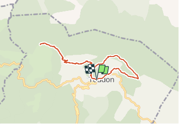
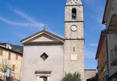
Tocht Stappen van 9,5 km beschikbaar op Provence-Alpes-Côte d'Azur, Alpes-Maritimes, Toudon. Deze tocht wordt voorgesteld door GrouGary.
Beschrijving
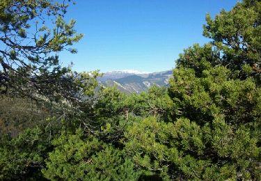
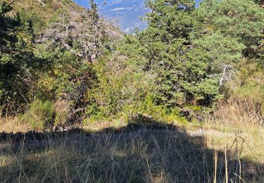
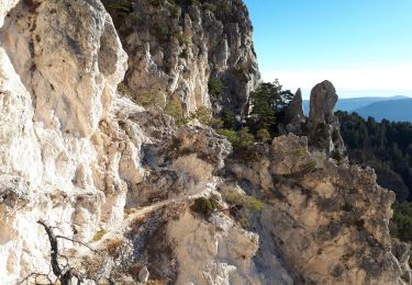
Petite boucle d'automne, sur sentier balisé et sans difficulté technique.
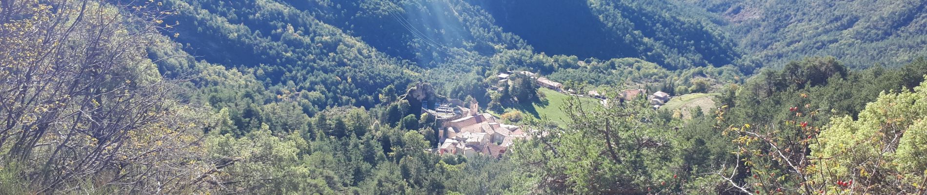
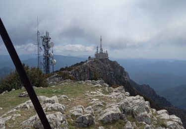
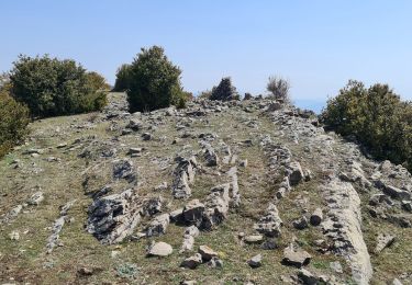
Vue à 360° sur l'Esteron sauvage et tourmenté, le Mercantour
Plaatsbepaling
Land:
France
Regio :
Provence-Alpes-Côte d'Azur
Departement/Provincie :
Alpes-Maritimes
Gemeente :
Toudon
Locatie:
Unknown
Vertrek:(Dec)
Vertrek:(UTM)
348397 ; 4862632 (32T) N.
Opmerkingen
Wandeltochten in de omgeving
![Tocht Stappen Toudon - FFR - la Cime des Colettes - Photo](https://media.geolcdn.com/t/375/260/5c77e34d-ba93-4b2e-bc78-7f26fc9a91ff.jpg&format=jpg&maxdim=2)
![Stappen Stappen](https://static1.geolcdn.com/sitytour/trail-icons/101.png)
FFR - la Cime des Colettes
Stappen
Moeilijk
(1)
Toudon,
Provence-Alpes-Côte d'Azur,
Alpes-Maritimes,
France
![](/images/other/stat-length.png)
7,9 km | 15 km-effort
3h 23min
![](https://static1.geolcdn.com/siteimages/upload/files/16400158638029165_repeat_loop_refresh_sync_direction_icon.png)
Ja
![Tocht Te voet Toudon - Cime des Collettes - Photo](https://media.geolcdn.com/t/375/260/fd183395-f287-4a75-ab4d-8f82bd86c556.jpeg&format=jpg&maxdim=2)
![Te voet Te voet](https://static1.geolcdn.com/sitytour/trail-icons/100.png)
Cime des Collettes
Te voet
Gemakkelijk
Toudon,
Provence-Alpes-Côte d'Azur,
Alpes-Maritimes,
France
![](/images/other/stat-length.png)
7 km | 13,4 km-effort
3h 3min
![](https://static1.geolcdn.com/siteimages/upload/files/16400158638029165_repeat_loop_refresh_sync_direction_icon.png)
Ja
![Tocht Stappen Toudon - cime des Colettes - Photo](https://media.geolcdn.com/t/375/260/ext.jpg?maxdim=2&url=https%3A%2F%2Fservices.sitytrail.com%2FGeolivesWS%2FDownloadMedia.ashx%3FTrailID%3D234784%26Media%3Dfix__20131128111641.jpg)
![Stappen Stappen](https://static1.geolcdn.com/sitytour/trail-icons/101.png)
cime des Colettes
Stappen
Medium
(1)
Toudon,
Provence-Alpes-Côte d'Azur,
Alpes-Maritimes,
France
![](/images/other/stat-length.png)
7,7 km | 14,6 km-effort
3h 40min
![](https://static1.geolcdn.com/siteimages/upload/files/16400158638029165_repeat_loop_refresh_sync_direction_icon.png)
Neen
![Tocht Stappen Revest-les-Roches - Balme de Vial - Photo](https://media.geolcdn.com/t/375/260/73ac1471-1060-4737-8ded-c7a6c570aa13.jpg&format=jpg&maxdim=2)
![Stappen Stappen](https://static1.geolcdn.com/sitytour/trail-icons/101.png)
Balme de Vial
Stappen
Medium
Revest-les-Roches,
Provence-Alpes-Côte d'Azur,
Alpes-Maritimes,
France
![](/images/other/stat-length.png)
7,4 km | 14,6 km-effort
5h 1min
![](https://static1.geolcdn.com/siteimages/upload/files/16400158638029165_repeat_loop_refresh_sync_direction_icon.png)
Neen
![Tocht Stappen Revest-les-Roches - Mont Vial 1550m 18-04-22 - Photo](https://media.geolcdn.com/t/375/260/d6f644e7-05d3-4637-b742-d9794d83f920.jpg&format=jpg&maxdim=2)
![Stappen Stappen](https://static1.geolcdn.com/sitytour/trail-icons/101.png)
Mont Vial 1550m 18-04-22
Stappen
Medium
Revest-les-Roches,
Provence-Alpes-Côte d'Azur,
Alpes-Maritimes,
France
![](/images/other/stat-length.png)
9,7 km | 19,1 km-effort
3h 30min
![](https://static1.geolcdn.com/siteimages/upload/files/16400158638029165_repeat_loop_refresh_sync_direction_icon.png)
Ja
![Tocht Stappen Pierrefeu - mont brune - Photo](https://media.geolcdn.com/t/375/260/aaa7df74-5173-4c01-a387-0027aa66640a.jpg&format=jpg&maxdim=2)
![Stappen Stappen](https://static1.geolcdn.com/sitytour/trail-icons/101.png)
mont brune
Stappen
Moeilijk
Pierrefeu,
Provence-Alpes-Côte d'Azur,
Alpes-Maritimes,
France
![](/images/other/stat-length.png)
8 km | 13,7 km-effort
3h 13min
![](https://static1.geolcdn.com/siteimages/upload/files/16400158638029165_repeat_loop_refresh_sync_direction_icon.png)
Ja
![Tocht Te voet Villars-sur-Var - Chapelle Saint-Jean - Photo](https://media.geolcdn.com/t/375/260/d00b81a8-2e28-44d5-b86a-fc3ec125a764.jpeg&format=jpg&maxdim=2)
![Te voet Te voet](https://static1.geolcdn.com/sitytour/trail-icons/100.png)
Chapelle Saint-Jean
Te voet
Gemakkelijk
Villars-sur-Var,
Provence-Alpes-Côte d'Azur,
Alpes-Maritimes,
France
![](/images/other/stat-length.png)
5 km | 9,7 km-effort
2h 12min
![](https://static1.geolcdn.com/siteimages/upload/files/16400158638029165_repeat_loop_refresh_sync_direction_icon.png)
Ja
![Tocht Stappen Toudon - Baisse des Colettes et Mt Brune de Toudon - Photo](https://media.geolcdn.com/t/375/260/20f8a02d-71d1-45f3-9a82-b8f740ad91d7.jpg&format=jpg&maxdim=2)
![Stappen Stappen](https://static1.geolcdn.com/sitytour/trail-icons/101.png)
Baisse des Colettes et Mt Brune de Toudon
Stappen
Medium
(1)
Toudon,
Provence-Alpes-Côte d'Azur,
Alpes-Maritimes,
France
![](/images/other/stat-length.png)
13,3 km | 24 km-effort
4h 39min
![](https://static1.geolcdn.com/siteimages/upload/files/16400158638029165_repeat_loop_refresh_sync_direction_icon.png)
Ja
![Stappen Stappen](https://static1.geolcdn.com/sitytour/trail-icons/101.png)
Malaussene : Le Canal de l'Adous
Stappen
Medium
Malaussène,
Provence-Alpes-Côte d'Azur,
Alpes-Maritimes,
France
![](/images/other/stat-length.png)
8,8 km | 11,8 km-effort
3h 59min
![](https://static1.geolcdn.com/siteimages/upload/files/16400158638029165_repeat_loop_refresh_sync_direction_icon.png)
Ja