![](/images/other/stat-length.png)
![Tocht Stappen Lazer - Le lac de Lazer par La Chapelle StJean - Photo](https://media.geolcdn.com/t/1900/400/578d4a1c-7512-4632-8926-02aded433ec1.jpg&format=pjpeg&maxdim=2)
Le lac de Lazer par La Chapelle StJean
babouille
Gebruiker
![Lengte](/images/other/stat-length.png)
![Max. hoogte](https://static1.geolcdn.com/siteimages/upload/files/1508320355ic_sort_altitude_max_24dp.png)
![Positief hoogteverschil](https://static1.geolcdn.com/siteimages/upload/files/1508320355ic_sort_den_pos_24dp.png)
![Km-Effort](/images/other/stat-length.png)
![Min. hoogte](https://static1.geolcdn.com/siteimages/upload/files/1508320355ic_sort_altitude_min_24dp.png)
![Negatief hoogteverschil](https://static1.geolcdn.com/siteimages/upload/files/1508320355ic_sort_den_neg_24dp.png)
![Boucle](https://static1.geolcdn.com/siteimages/upload/files/16400158638029165_repeat_loop_refresh_sync_direction_icon.png)
![Stappen](https://static1.geolcdn.com/sitytour/trail-icons/101.png)
1h40
Moeilijkheid : Medium
![Scan deze QR-code om de tocht te openen in de SityTrail-applicatie](https://capi.geolives.com/qq0zvz2zws4bq2lad0pu/sitytour/trails/3851430/qr.png?size=200)
Gratisgps-wandelapplicatie
Over ons
Tocht Stappen van 6,5 km beschikbaar op Provence-Alpes-Côte d'Azur, Hautes-Alpes, Lazer. Deze tocht wordt voorgesteld door babouille.
Beschrijving
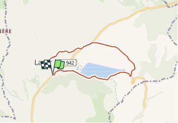
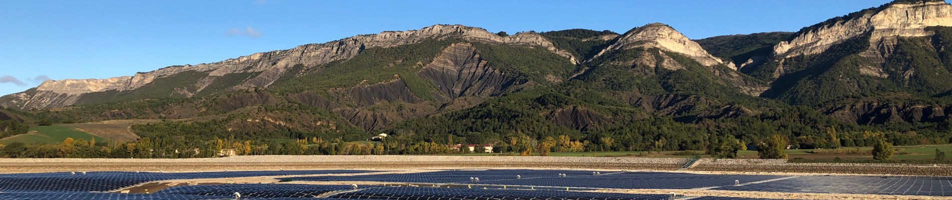
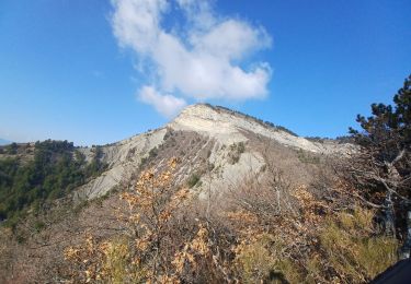
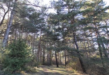
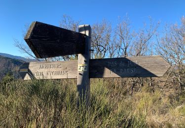
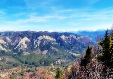
Rando facile . Départ au parking en face de la mairie de LAZER . Partir vers le nord sur la départementale 942 sur 20 mètres puis bifurquer à droite en direction de la retenue collinaire qu'est la lac de Lazer . ce plan d'eau est recouvert de panneaux solaire ( A notre passage le lac avait été vidé ) pour améliorer les performances de la centrale hydraulique qui se trouve à l'est où la rando quitte le lac en direction du nord ouest. On rejoint la D942 que l'on parcourt sur environ 30m puis quitter la départementale par la première route à droit vers "Pradon" et poursuivre jusqu'à la chapelle St Jean où l'on redescent vers le sud pour rejoindre le Point de départ.
Plaatsbepaling
Opmerkingen
Wandeltochten in de omgeving
![Tocht Mountainbike Laragne-Montéglin - Laragne 2008 - Photo](https://media.geolcdn.com/t/375/260/ext.jpg?maxdim=2&url=https%3A%2F%2Fstatic1.geolcdn.com%2Fsiteimages%2Fupload%2Ffiles%2F1524743154velo.jpg)
![Mountainbike Mountainbike](https://static1.geolcdn.com/sitytour/trail-icons/202.png)
Mountainbike
![](/images/other/stat-length.png)
![](https://static1.geolcdn.com/siteimages/upload/files/16400158638029165_repeat_loop_refresh_sync_direction_icon.png)
![Tocht Stappen Ventavon - VENTAVON . crête de Colombier , roc de l Escubier o m s - Photo](https://media.geolcdn.com/t/375/260/eb2996c2-264a-421d-8745-31a34e3b5708.jpg&format=jpg&maxdim=2)
![Stappen Stappen](https://static1.geolcdn.com/sitytour/trail-icons/101.png)
Stappen
![](/images/other/stat-length.png)
![](https://static1.geolcdn.com/siteimages/upload/files/16400158638029165_repeat_loop_refresh_sync_direction_icon.png)
![Tocht Mountainbike Thèze - 210322 rouviere theze a velo - Photo](https://media.geolcdn.com/t/375/260/11332bd4-f1eb-453a-b568-0b37b31d0a1b.jpg&format=jpg&maxdim=2)
![Mountainbike Mountainbike](https://static1.geolcdn.com/sitytour/trail-icons/202.png)
Mountainbike
![](/images/other/stat-length.png)
![](https://static1.geolcdn.com/siteimages/upload/files/16400158638029165_repeat_loop_refresh_sync_direction_icon.png)
![Tocht Stappen Laragne-Montéglin - Vieil Arzellier/Vieil Eyguians.21/02/21. - Photo](https://media.geolcdn.com/t/375/260/addc1cc9-a190-4b69-a026-86524405f5ae.jpg&format=jpg&maxdim=2)
![Stappen Stappen](https://static1.geolcdn.com/sitytour/trail-icons/101.png)
Stappen
![](/images/other/stat-length.png)
![](https://static1.geolcdn.com/siteimages/upload/files/16400158638029165_repeat_loop_refresh_sync_direction_icon.png)
![Tocht Stappen Lazer - Départ Lazer et Tour du Château d’Arzelier - Photo](https://media.geolcdn.com/t/375/260/2a914d9f-e070-4566-89b6-d5d17e8cc63d.jpg&format=jpg&maxdim=2)
![Stappen Stappen](https://static1.geolcdn.com/sitytour/trail-icons/101.png)
Stappen
![](/images/other/stat-length.png)
![](https://static1.geolcdn.com/siteimages/upload/files/16400158638029165_repeat_loop_refresh_sync_direction_icon.png)
![Tocht Stappen Lazer - Roc de L'Esculier Via Le Lauza - Photo](https://media.geolcdn.com/t/375/260/cb4f9c34-5e6c-4839-86ea-8b005e203066.jpg&format=jpg&maxdim=2)
![Stappen Stappen](https://static1.geolcdn.com/sitytour/trail-icons/101.png)
Stappen
![](/images/other/stat-length.png)
![](https://static1.geolcdn.com/siteimages/upload/files/16400158638029165_repeat_loop_refresh_sync_direction_icon.png)
![Tocht Te voet Garde-Colombe - Crête de St Genis - Photo](https://media.geolcdn.com/t/375/260/ext.jpg?maxdim=2&url=https%3A%2F%2Fstatic1.geolcdn.com%2Fsiteimages%2Fupload%2Ffiles%2F1545311037marcheuse_200dpi.jpg)
![Te voet Te voet](https://static1.geolcdn.com/sitytour/trail-icons/100.png)
Te voet
![](/images/other/stat-length.png)
![](https://static1.geolcdn.com/siteimages/upload/files/16400158638029165_repeat_loop_refresh_sync_direction_icon.png)
![Tocht Mountainbike Laragne-Montéglin - Grande Traversée des PréAlpes à VTT : Arzeliers - Ribiers - Photo](https://media.geolcdn.com/t/375/260/ext.jpg?maxdim=2&url=https%3A%2F%2Fservices.sitytrail.com%2FGeolivesWS%2FDownloadMedia.ashx%3FTrailID%3D102170%26Media%3D2560_2.jpg)
![Mountainbike Mountainbike](https://static1.geolcdn.com/sitytour/trail-icons/202.png)
Mountainbike
![](/images/other/stat-length.png)
![](https://static1.geolcdn.com/siteimages/upload/files/16400158638029165_repeat_loop_refresh_sync_direction_icon.png)
![Tocht Te voet Laragne-Montéglin - Les Ourbos 376 + - Photo](https://media.geolcdn.com/t/375/260/ext.jpg?maxdim=2&url=https%3A%2F%2Fstatic1.geolcdn.com%2Fsiteimages%2Fupload%2Ffiles%2F1545311037marcheuse_200dpi.jpg)
![Te voet Te voet](https://static1.geolcdn.com/sitytour/trail-icons/100.png)
Te voet
![](/images/other/stat-length.png)
![](https://static1.geolcdn.com/siteimages/upload/files/16400158638029165_repeat_loop_refresh_sync_direction_icon.png)