![](/images/other/stat-length.png)
![Tocht Te voet Wellin - SityTrail - BECASINE - SOHIER - Photo](https://media.geolcdn.com/t/1900/400/ext.pjpeg?maxdim=2&url=https%3A%2F%2Fstatic1.geolcdn.com%2Fsiteimages%2Fupload%2Ffiles%2F1545311037marcheuse_200dpi.jpg)
SityTrail - BECASINE - SOHIER
Parc naturel de l'Ardenne méridionale
Gebruiker
![Lengte](/images/other/stat-length.png)
Lengte
4 km
![Max. hoogte](https://static1.geolcdn.com/siteimages/upload/files/1508320355ic_sort_altitude_max_24dp.png)
Max. hoogte
342 m
![Positief hoogteverschil](https://static1.geolcdn.com/siteimages/upload/files/1508320355ic_sort_den_pos_24dp.png)
Positief hoogteverschil
43 m
![Km-Effort](/images/other/stat-length.png)
Km-Effort
4,5 km
![Min. hoogte](https://static1.geolcdn.com/siteimages/upload/files/1508320355ic_sort_altitude_min_24dp.png)
Min. hoogte
308 m
![Negatief hoogteverschil](https://static1.geolcdn.com/siteimages/upload/files/1508320355ic_sort_den_neg_24dp.png)
Negatief hoogteverschil
43 m
![Boucle](https://static1.geolcdn.com/siteimages/upload/files/16400158638029165_repeat_loop_refresh_sync_direction_icon.png)
Boucle
Ja
Datum van aanmaak :
2023-10-18 11:51:03.023
Laatste wijziging :
2024-04-08 14:52:35.294
![Te voet](https://static1.geolcdn.com/sitytour/trail-icons/100.png)
1h01
Moeilijkheid : Gemakkelijk
![Scan deze QR-code om de tocht te openen in de SityTrail-applicatie](https://capi.geolives.com/qq0zvz2zws4bq2lad0pu/sitytour/trails/3843502/qr.png?size=200)
Gratisgps-wandelapplicatie
Over ons
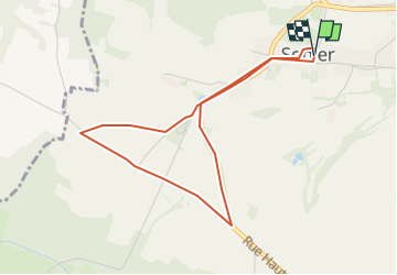
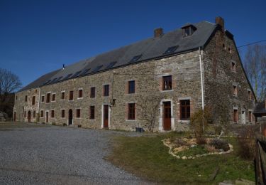
Tocht Te voet van 4 km beschikbaar op Wallonië, Luxemburg, Wellin. Deze tocht wordt voorgesteld door Parc naturel de l'Ardenne méridionale .
Beschrijving
Sentier accessible en Becasine au départ de Sohier (Wellin).
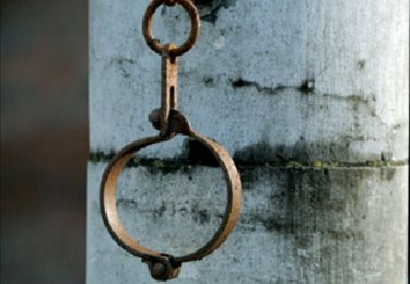
Avant de vous lancer sur ce circuit, nous vous renvoyons vers la brochure dédiée afin de prendre connaissance des caractéristiques techniques propres à l'utilisation de la Becasine.
Plaatsbepaling
Land:
Belgium
Regio :
Wallonië
Departement/Provincie :
Luxemburg
Gemeente :
Wellin
Locatie:
Unknown
Vertrek:(Dec)
Vertrek:(UTM)
648190 ; 5548299 (31U) N.
Opmerkingen
Wandeltochten in de omgeving
![Stappen Stappen](https://static1.geolcdn.com/sitytour/trail-icons/101.png)
RB-Na-29_Un terroir d’une biodiversité remarquable
Stappen
Zeer moeilijk
(9)
Beauraing,
Wallonië,
Namen,
Belgium
![](/images/other/stat-length.png)
22 km | 28 km-effort
6h 28min
![](https://static1.geolcdn.com/siteimages/upload/files/16400158638029165_repeat_loop_refresh_sync_direction_icon.png)
Ja
![Stappen Stappen](https://static1.geolcdn.com/sitytour/trail-icons/101.png)
RB-Lu-25_Wellin
Stappen
Heel gemakkelijk
(6)
Wellin,
Wallonië,
Luxemburg,
Belgium
![](/images/other/stat-length.png)
26 km | 33 km-effort
6h 46min
![](https://static1.geolcdn.com/siteimages/upload/files/16400158638029165_repeat_loop_refresh_sync_direction_icon.png)
Ja
![Tocht Stappen Beauraing - De natuurpracht rondom Pondrôme & Revogne - Photo](https://media.geolcdn.com/t/375/260/ext.jpg?maxdim=2&url=https%3A%2F%2Fservices.sitytrail.com%2FGeolivesWS%2FDownloadMedia.ashx%3FTrailID%3D194872%26Media%3Db26114ed-9694-4d92-b6de-0f7d315a40e9.jpg)
![Stappen Stappen](https://static1.geolcdn.com/sitytour/trail-icons/101.png)
De natuurpracht rondom Pondrôme & Revogne
Stappen
Gemakkelijk
(8)
Beauraing,
Wallonië,
Namen,
Belgium
![](/images/other/stat-length.png)
8,9 km | 10,7 km-effort
2h 18min
![](https://static1.geolcdn.com/siteimages/upload/files/16400158638029165_repeat_loop_refresh_sync_direction_icon.png)
Ja
![Tocht Stappen Beauraing - Natuurwandeling tussen Pondrôme en Revogne - Photo](https://media.geolcdn.com/t/375/260/ext.jpg?maxdim=2&url=https%3A%2F%2Fservices.sitytrail.com%2FGeolivesWS%2FDownloadMedia.ashx%3FTrailID%3D171081%26Media%3Db26114ed-9694-4d92-b6de-0f7d315a40e9.jpg)
![Stappen Stappen](https://static1.geolcdn.com/sitytour/trail-icons/101.png)
Natuurwandeling tussen Pondrôme en Revogne
Stappen
Medium
(6)
Beauraing,
Wallonië,
Namen,
Belgium
![](/images/other/stat-length.png)
8,6 km | 10,3 km-effort
2h 0min
![](https://static1.geolcdn.com/siteimages/upload/files/16400158638029165_repeat_loop_refresh_sync_direction_icon.png)
Ja
![Tocht Stappen Wellin - Wéry_Variante (WE 06) - Photo](https://media.geolcdn.com/t/375/260/ext.jpg?maxdim=2&url=https%3A%2F%2Fservices.sitytrail.com%2FGeolivesWS%2FDownloadMedia.ashx%3FTrailID%3D334441%26Media%3D69ef9e8a-0435-41bc-a5d3-d329c2516b48.JPG)
![Stappen Stappen](https://static1.geolcdn.com/sitytour/trail-icons/101.png)
Wéry_Variante (WE 06)
Stappen
Moeilijk
(5)
Wellin,
Wallonië,
Luxemburg,
Belgium
![](/images/other/stat-length.png)
11,4 km | 15,5 km-effort
3h 30min
![](https://static1.geolcdn.com/siteimages/upload/files/16400158638029165_repeat_loop_refresh_sync_direction_icon.png)
Ja
![Stappen Stappen](https://static1.geolcdn.com/sitytour/trail-icons/101.png)
RB-Na-29-racc-2_Un terroir d’une biodiversité remarquable
Stappen
Zeer moeilijk
(2)
Beauraing,
Wallonië,
Namen,
Belgium
![](/images/other/stat-length.png)
19 km | 24 km-effort
5h 20min
![](https://static1.geolcdn.com/siteimages/upload/files/16400158638029165_repeat_loop_refresh_sync_direction_icon.png)
Ja
![Tocht Stappen Wellin - Balade de Wellin à Froidlieu - Photo](https://media.geolcdn.com/t/375/260/ext.jpg?maxdim=2&url=https%3A%2F%2Fservices.sitytrail.com%2FGeolivesWS%2FDownloadMedia.ashx%3FTrailID%3D550482%26Media%3D6bfae291-bc04-4a99-8008-dd078d6a2b97.jpg)
![Stappen Stappen](https://static1.geolcdn.com/sitytour/trail-icons/101.png)
Balade de Wellin à Froidlieu
Stappen
Gemakkelijk
(3)
Wellin,
Wallonië,
Luxemburg,
Belgium
![](/images/other/stat-length.png)
8,8 km | 10,9 km-effort
2h 20min
![](https://static1.geolcdn.com/siteimages/upload/files/16400158638029165_repeat_loop_refresh_sync_direction_icon.png)
Ja
![Stappen Stappen](https://static1.geolcdn.com/sitytour/trail-icons/101.png)
RB-Lu-25_Wellin_via-racc-1-et-var
Stappen
Zeer moeilijk
(1)
Wellin,
Wallonië,
Luxemburg,
Belgium
![](/images/other/stat-length.png)
25 km | 33 km-effort
7h 23min
![](https://static1.geolcdn.com/siteimages/upload/files/16400158638029165_repeat_loop_refresh_sync_direction_icon.png)
Ja
![Tocht Fiets Beauraing - Fietscircuit : Revogne, Lavaux-Sainte-Anne, Focant, Revogne - Photo](https://media.geolcdn.com/t/375/260/ext.jpg?maxdim=2&url=https%3A%2F%2Fservices.sitytrail.com%2FGeolivesWS%2FDownloadMedia.ashx%3FTrailID%3D249047%26Media%3D089edb7d-e9c7-4430-b50a-c8e7c75c5b5d.jpg)
![Fiets Fiets](https://static1.geolcdn.com/sitytour/trail-icons/200.png)
Fietscircuit : Revogne, Lavaux-Sainte-Anne, Focant, Revogne
Fiets
Heel gemakkelijk
(3)
Beauraing,
Wallonië,
Namen,
Belgium
![](/images/other/stat-length.png)
18,1 km | 21 km-effort
1h 3min
![](https://static1.geolcdn.com/siteimages/upload/files/16400158638029165_repeat_loop_refresh_sync_direction_icon.png)
Ja