


Tupiza

Geert H.
Gebruiker
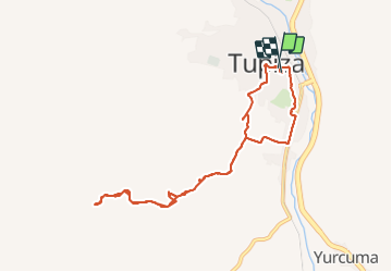

Lengte
12,6 km

Max. hoogte
3119 m

Positief hoogteverschil
250 m
Km-Effort
15,9 km

Min. hoogte
2940 m

Negatief hoogteverschil
253 m
Boucle
Ja
Datum van aanmaak :
2023-10-16 12:04:14.376
Laatste wijziging :
2023-12-31 09:01:22.31
3h36
Moeilijkheid : Moeilijk

Gratisgps-wandelapplicatie
 SityTrail
IGN / Geografische instituten
SityTrail World
De wereld gaat voor u open
Over ons
Tocht Stappen van 12,6 km beschikbaar op Potosí, Sur Chichas, Tupiza. Deze tocht wordt voorgesteld door Geert H..
Plaatsbepaling
Land:
Bolivia, Plurinational State of
Regio :
Potosí
Departement/Provincie :
Sur Chichas
Gemeente :
Tupiza
Locatie:
Unknown
Vertrek:(Dec)
Vertrek:(UTM)
218170 ; 7626207 (20K) Z.
Opmerkingen
Wandeltochten in de omgeving