![](/images/other/stat-length.png)
![Tocht Stappen Saint-Astier - St Astier Puy-Ferrat 10km - Photo](https://media.geolcdn.com/t/1900/400/ext.pjpeg?maxdim=2&url=https%3A%2F%2Fstatic1.geolcdn.com%2Fsiteimages%2Fupload%2Ffiles%2F1553511878bg_sport_marche.png)
St Astier Puy-Ferrat 10km
YV24
Gebruiker
![Lengte](/images/other/stat-length.png)
Lengte
10,3 km
![Max. hoogte](https://static1.geolcdn.com/siteimages/upload/files/1508320355ic_sort_altitude_max_24dp.png)
Max. hoogte
195 m
![Positief hoogteverschil](https://static1.geolcdn.com/siteimages/upload/files/1508320355ic_sort_den_pos_24dp.png)
Positief hoogteverschil
207 m
![Km-Effort](/images/other/stat-length.png)
Km-Effort
13 km
![Min. hoogte](https://static1.geolcdn.com/siteimages/upload/files/1508320355ic_sort_altitude_min_24dp.png)
Min. hoogte
76 m
![Negatief hoogteverschil](https://static1.geolcdn.com/siteimages/upload/files/1508320355ic_sort_den_neg_24dp.png)
Negatief hoogteverschil
208 m
![Boucle](https://static1.geolcdn.com/siteimages/upload/files/16400158638029165_repeat_loop_refresh_sync_direction_icon.png)
Boucle
Ja
Datum van aanmaak :
2015-02-07 00:00:00.0
Laatste wijziging :
2015-02-07 00:00:00.0
![Stappen](https://static1.geolcdn.com/sitytour/trail-icons/101.png)
2h53
Moeilijkheid : Gemakkelijk
![Scan deze QR-code om de tocht te openen in de SityTrail-applicatie](https://capi.geolives.com/qq0zvz2zws4bq2lad0pu/sitytour/trails/383935/qr.png?size=200)
Gratisgps-wandelapplicatie
Over ons
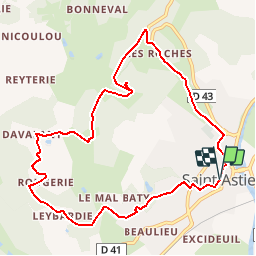
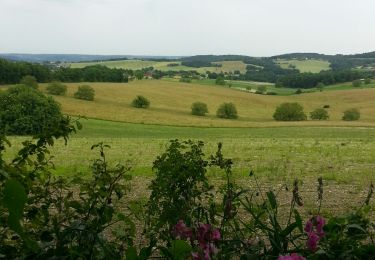
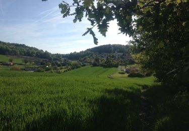
Tocht Stappen van 10,3 km beschikbaar op Nieuw-Aquitanië, Dordogne, Saint-Astier. Deze tocht wordt voorgesteld door YV24.
Beschrijving
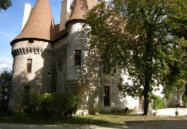
Selon PDIPR n°2 carte St Astier. Circuit bien tracé, vallonné, praticable en tout temps. Petite "Chapelle des Bois" à l'origine du nom de St Astier.
Plaatsbepaling
Land:
France
Regio :
Nieuw-Aquitanië
Departement/Provincie :
Dordogne
Gemeente :
Saint-Astier
Locatie:
Unknown
Vertrek:(Dec)
Vertrek:(UTM)
305664 ; 5002053 (31T) N.
Opmerkingen
Wandeltochten in de omgeving
![Tocht Stappen Saint-Astier - 24 Saint-Astier - Photo](https://media.geolcdn.com/t/375/260/ext.jpg?maxdim=2&url=https%3A%2F%2Fservices.sitytrail.com%2FGeolivesWS%2FDownloadMedia.ashx%3FTrailID%3D696131%26Media%3D20170210155608.jpg)
![Stappen Stappen](https://static1.geolcdn.com/sitytour/trail-icons/101.png)
24 Saint-Astier
Stappen
Gemakkelijk
(1)
Saint-Astier,
Nieuw-Aquitanië,
Dordogne,
France
![](/images/other/stat-length.png)
11,4 km | 14,3 km-effort
2h 42min
![](https://static1.geolcdn.com/siteimages/upload/files/16400158638029165_repeat_loop_refresh_sync_direction_icon.png)
Ja
![Tocht Stappen Saint-Astier - GR654 ST ASTIER BERGERAC PINEL - Photo](https://media.geolcdn.com/t/375/260/ext.jpg?maxdim=2&url=https%3A%2F%2Fstatic1.geolcdn.com%2Fsiteimages%2Fupload%2Ffiles%2F1553511878bg_sport_marche.png)
![Stappen Stappen](https://static1.geolcdn.com/sitytour/trail-icons/101.png)
GR654 ST ASTIER BERGERAC PINEL
Stappen
Moeilijk
(3)
Saint-Astier,
Nieuw-Aquitanië,
Dordogne,
France
![](/images/other/stat-length.png)
122 km | 150 km-effort
31h 13min
![](https://static1.geolcdn.com/siteimages/upload/files/16400158638029165_repeat_loop_refresh_sync_direction_icon.png)
Neen
![Tocht Te voet Saint-Aquilin - Boucle des Châteaux - Photo](https://media.geolcdn.com/t/375/260/f74018a9-b74f-4277-a488-8850f79cec74.jpeg&format=jpg&maxdim=2)
![Te voet Te voet](https://static1.geolcdn.com/sitytour/trail-icons/100.png)
Boucle des Châteaux
Te voet
Gemakkelijk
Saint-Aquilin,
Nieuw-Aquitanië,
Dordogne,
France
![](/images/other/stat-length.png)
11,3 km | 15,4 km-effort
3h 29min
![](https://static1.geolcdn.com/siteimages/upload/files/16400158638029165_repeat_loop_refresh_sync_direction_icon.png)
Neen
![Tocht Stappen Saint-Aquilin - St Aquilin Chateaux 12km - Photo](https://media.geolcdn.com/t/375/260/ext.jpg?maxdim=2&url=https%3A%2F%2Fstatic1.geolcdn.com%2Fsiteimages%2Fupload%2Ffiles%2F1553511878bg_sport_marche.png)
![Stappen Stappen](https://static1.geolcdn.com/sitytour/trail-icons/101.png)
St Aquilin Chateaux 12km
Stappen
Gemakkelijk
(1)
Saint-Aquilin,
Nieuw-Aquitanië,
Dordogne,
France
![](/images/other/stat-length.png)
11,9 km | 16,3 km-effort
3h 33min
![](https://static1.geolcdn.com/siteimages/upload/files/16400158638029165_repeat_loop_refresh_sync_direction_icon.png)
Ja
![Tocht Te voet Saint-Aquilin - Promenade de Charroux - Photo](https://media.geolcdn.com/t/375/260/8ff5e993-dbe3-4130-878c-f2efcea2d49e.jpeg&format=jpg&maxdim=2)
![Te voet Te voet](https://static1.geolcdn.com/sitytour/trail-icons/100.png)
Promenade de Charroux
Te voet
Gemakkelijk
Saint-Aquilin,
Nieuw-Aquitanië,
Dordogne,
France
![](/images/other/stat-length.png)
4,2 km | 5,8 km-effort
1h 19min
![](https://static1.geolcdn.com/siteimages/upload/files/16400158638029165_repeat_loop_refresh_sync_direction_icon.png)
Ja
![Tocht Stappen Annesse-et-Beaulieu - Boucle de Gravelle - Photo](https://media.geolcdn.com/t/375/260/7e82b9c5-c11d-4184-bd2d-a796ef1ab2b8.jpg&format=jpg&maxdim=2)
![Stappen Stappen](https://static1.geolcdn.com/sitytour/trail-icons/101.png)
Boucle de Gravelle
Stappen
Moeilijk
Annesse-et-Beaulieu,
Nieuw-Aquitanië,
Dordogne,
France
![](/images/other/stat-length.png)
13,1 km | 16,2 km-effort
3h 40min
![](https://static1.geolcdn.com/siteimages/upload/files/16400158638029165_repeat_loop_refresh_sync_direction_icon.png)
Ja
![Tocht Stappen Saint-Astier - Boucle de Saint Astier - Photo](https://media.geolcdn.com/t/375/260/327f719c-4b69-427a-863c-6fd7c39fc1ff.jpg&format=jpg&maxdim=2)
![Stappen Stappen](https://static1.geolcdn.com/sitytour/trail-icons/101.png)
Boucle de Saint Astier
Stappen
Moeilijk
Saint-Astier,
Nieuw-Aquitanië,
Dordogne,
France
![](/images/other/stat-length.png)
12,6 km | 16,3 km-effort
3h 42min
![](https://static1.geolcdn.com/siteimages/upload/files/16400158638029165_repeat_loop_refresh_sync_direction_icon.png)
Ja
![Tocht Stappen Léguillac-de-l'Auche - Leguillac 12km - Photo](https://media.geolcdn.com/t/375/260/6b543d32-0711-4fac-8c8e-611b0e7aa5e2.jpg&format=jpg&maxdim=2)
![Stappen Stappen](https://static1.geolcdn.com/sitytour/trail-icons/101.png)
Leguillac 12km
Stappen
Medium
Léguillac-de-l'Auche,
Nieuw-Aquitanië,
Dordogne,
France
![](/images/other/stat-length.png)
12,1 km | 16,1 km-effort
2h 45min
![](https://static1.geolcdn.com/siteimages/upload/files/16400158638029165_repeat_loop_refresh_sync_direction_icon.png)
Ja
![Tocht Stappen Léguillac-de-l'Auche - 24 Léguillac de l'Auche - Photo](https://media.geolcdn.com/t/375/260/ext.jpg?maxdim=2&url=https%3A%2F%2Fservices.sitytrail.com%2FGeolivesWS%2FDownloadMedia.ashx%3FTrailID%3D739246%26Media%3D20170423183223.jpg)
![Stappen Stappen](https://static1.geolcdn.com/sitytour/trail-icons/101.png)
24 Léguillac de l'Auche
Stappen
Gemakkelijk
Léguillac-de-l'Auche,
Nieuw-Aquitanië,
Dordogne,
France
![](/images/other/stat-length.png)
13,8 km | 18 km-effort
3h 57min
![](https://static1.geolcdn.com/siteimages/upload/files/16400158638029165_repeat_loop_refresh_sync_direction_icon.png)
Ja