![](/images/other/stat-length.png)
![Tocht Stappen Plombières-les-Bains - Cirkwi-Les_fontaines_du_Ban_d_Ajol - Photo](https://media.geolcdn.com/t/1900/400/ext.pjpeg?maxdim=2&url=https%3A%2F%2Fstatic1.geolcdn.com%2Fsiteimages%2Fupload%2Ffiles%2F1553511878bg_sport_marche.png)
Cirkwi-Les_fontaines_du_Ban_d_Ajol
Emmanuel Remy
Gebruiker
![Lengte](/images/other/stat-length.png)
Lengte
4,2 km
![Max. hoogte](https://static1.geolcdn.com/siteimages/upload/files/1508320355ic_sort_altitude_max_24dp.png)
Max. hoogte
579 m
![Positief hoogteverschil](https://static1.geolcdn.com/siteimages/upload/files/1508320355ic_sort_den_pos_24dp.png)
Positief hoogteverschil
142 m
![Km-Effort](/images/other/stat-length.png)
Km-Effort
6,1 km
![Min. hoogte](https://static1.geolcdn.com/siteimages/upload/files/1508320355ic_sort_altitude_min_24dp.png)
Min. hoogte
430 m
![Negatief hoogteverschil](https://static1.geolcdn.com/siteimages/upload/files/1508320355ic_sort_den_neg_24dp.png)
Negatief hoogteverschil
148 m
![Boucle](https://static1.geolcdn.com/siteimages/upload/files/16400158638029165_repeat_loop_refresh_sync_direction_icon.png)
Boucle
Ja
Datum van aanmaak :
2023-10-12 10:54:21.109
Laatste wijziging :
2023-10-12 10:54:21.109
![Stappen](https://static1.geolcdn.com/sitytour/trail-icons/101.png)
1h22
Moeilijkheid : Medium
![Scan deze QR-code om de tocht te openen in de SityTrail-applicatie](https://capi.geolives.com/qq0zvz2zws4bq2lad0pu/sitytour/trails/3837502/qr.png?size=200)
Gratisgps-wandelapplicatie
Over ons
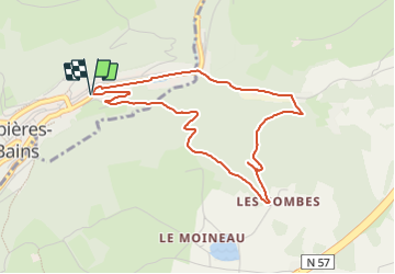
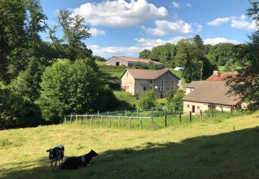
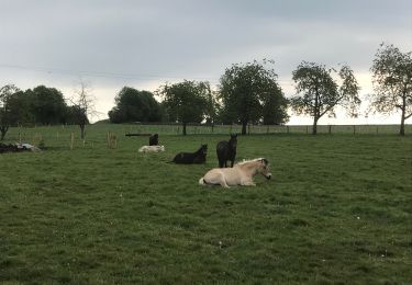
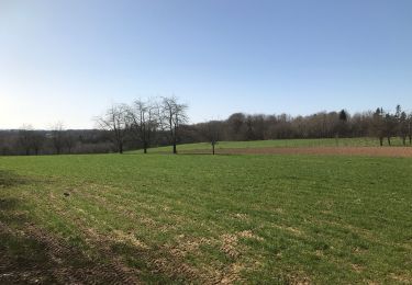
Tocht Stappen van 4,2 km beschikbaar op Grand Est, Vogezen, Plombières-les-Bains. Deze tocht wordt voorgesteld door Emmanuel Remy.
Beschrijving
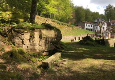
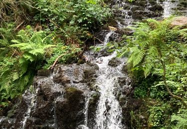
De nombreuses fontaines en bordure de chemin permettaient aux promeneurs de se rafraîchir et de s'abreuver. Il en reste quelques-unes pourtant bien modestes qui portent des noms prestigieux, tandis que d'autres sont tombées dans l'oubli.
Plaatsbepaling
Land:
France
Regio :
Grand Est
Departement/Provincie :
Vogezen
Gemeente :
Plombières-les-Bains
Locatie:
Unknown
Vertrek:(Dec)
Vertrek:(UTM)
310675 ; 5315691 (32T) N.
Opmerkingen
Wandeltochten in de omgeving
![Tocht Stappen Plombières-les-Bains - plombières et les Ruaux - Photo](https://media.geolcdn.com/t/375/260/ext.jpg?maxdim=2&url=https%3A%2F%2Fservices.sitytrail.com%2FGeolivesWS%2FDownloadMedia.ashx%3FTrailID%3D558197%26Media%3D20160424103736.jpg)
![Stappen Stappen](https://static1.geolcdn.com/sitytour/trail-icons/101.png)
plombières et les Ruaux
Stappen
Gemakkelijk
(1)
Plombières-les-Bains,
Grand Est,
Vogezen,
France
![](/images/other/stat-length.png)
7,9 km | 10,2 km-effort
2h 28min
![](https://static1.geolcdn.com/siteimages/upload/files/16400158638029165_repeat_loop_refresh_sync_direction_icon.png)
Ja
![Tocht Stappen Le Val-d'Ajol - Cascade de Faymont - Photo](https://media.geolcdn.com/t/375/260/213786ee-7982-426a-8a56-d635bef7e711.jpg&format=jpg&maxdim=2)
![Stappen Stappen](https://static1.geolcdn.com/sitytour/trail-icons/101.png)
Cascade de Faymont
Stappen
Gemakkelijk
Le Val-d'Ajol,
Grand Est,
Vogezen,
France
![](/images/other/stat-length.png)
9,7 km | 13,7 km-effort
2h 44min
![](https://static1.geolcdn.com/siteimages/upload/files/16400158638029165_repeat_loop_refresh_sync_direction_icon.png)
Ja
![Tocht Noords wandelen Plombières-les-Bains - plombieres20221008 - Photo](https://media.geolcdn.com/t/375/260/79458fa7-7f9d-4ffa-9799-65637f84fe4b.jpg&format=jpg&maxdim=2)
![Noords wandelen Noords wandelen](https://static1.geolcdn.com/sitytour/trail-icons/102.png)
plombieres20221008
Noords wandelen
Heel gemakkelijk
Plombières-les-Bains,
Grand Est,
Vogezen,
France
![](/images/other/stat-length.png)
19,6 km | 25 km-effort
3h 18min
![](https://static1.geolcdn.com/siteimages/upload/files/16400158638029165_repeat_loop_refresh_sync_direction_icon.png)
Ja
![Tocht Paardrijden Fougerolles-Saint-Valbert - Moulin taquere 7kms - Photo](https://media.geolcdn.com/t/375/260/4908ffe4-012c-4ca8-910b-89ab7d96d808.jpg&format=jpg&maxdim=2)
![Paardrijden Paardrijden](https://static1.geolcdn.com/sitytour/trail-icons/301.png)
Moulin taquere 7kms
Paardrijden
Moeilijk
Fougerolles-Saint-Valbert,
Bourgondië-Franche-Comté,
Haute-Saône,
France
![](/images/other/stat-length.png)
7,6 km | 10,5 km-effort
1h 21min
![](https://static1.geolcdn.com/siteimages/upload/files/16400158638029165_repeat_loop_refresh_sync_direction_icon.png)
Ja
![Tocht Stappen Fougerolles-Saint-Valbert - Balade poney 6kms - Photo](https://media.geolcdn.com/t/375/260/1f2dc543-5f84-4925-9489-21df8a97fbf2.jpg&format=jpg&maxdim=2)
![Stappen Stappen](https://static1.geolcdn.com/sitytour/trail-icons/101.png)
Balade poney 6kms
Stappen
Medium
Fougerolles-Saint-Valbert,
Bourgondië-Franche-Comté,
Haute-Saône,
France
![](/images/other/stat-length.png)
6,3 km | 8 km-effort
Onbekend
![](https://static1.geolcdn.com/siteimages/upload/files/16400158638029165_repeat_loop_refresh_sync_direction_icon.png)
Ja
![Tocht Paardrijden Fougerolles-Saint-Valbert - Balade 1h vers chez le poix - Photo](https://media.geolcdn.com/t/375/260/505f2317-5f10-48d7-8d7f-f8c2631381af.jpg&format=jpg&maxdim=2)
![Paardrijden Paardrijden](https://static1.geolcdn.com/sitytour/trail-icons/301.png)
Balade 1h vers chez le poix
Paardrijden
Moeilijk
Fougerolles-Saint-Valbert,
Bourgondië-Franche-Comté,
Haute-Saône,
France
![](/images/other/stat-length.png)
6,1 km | 7,8 km-effort
1h 12min
![](https://static1.geolcdn.com/siteimages/upload/files/16400158638029165_repeat_loop_refresh_sync_direction_icon.png)
Ja
![Tocht Stappen Le Val-d'Ajol - Faymont - Photo](https://media.geolcdn.com/t/375/260/b01dd52c-3ff9-4388-ad09-29eaf047df15.jpg&format=jpg&maxdim=2)
![Stappen Stappen](https://static1.geolcdn.com/sitytour/trail-icons/101.png)
Faymont
Stappen
Gemakkelijk
Le Val-d'Ajol,
Grand Est,
Vogezen,
France
![](/images/other/stat-length.png)
9,4 km | 13,1 km-effort
2h 51min
![](https://static1.geolcdn.com/siteimages/upload/files/16400158638029165_repeat_loop_refresh_sync_direction_icon.png)
Ja
![Tocht Stappen Plombières-les-Bains - 30-07-23 Plombières : circuit jaune n°9 - Photo](https://media.geolcdn.com/t/375/260/c8d7f0dc-06b9-49d4-b934-200f7715b734.jpg&format=jpg&maxdim=2)
![Stappen Stappen](https://static1.geolcdn.com/sitytour/trail-icons/101.png)
30-07-23 Plombières : circuit jaune n°9
Stappen
Medium
Plombières-les-Bains,
Grand Est,
Vogezen,
France
![](/images/other/stat-length.png)
10,7 km | 15,5 km-effort
2h 32min
![](https://static1.geolcdn.com/siteimages/upload/files/16400158638029165_repeat_loop_refresh_sync_direction_icon.png)
Ja
![Tocht Stappen Le Val-d'Ajol - Val d’Ajol - Photo](https://media.geolcdn.com/t/375/260/51840968-33fb-4220-bfd0-0c8643bc6107.jpg&format=jpg&maxdim=2)
![Stappen Stappen](https://static1.geolcdn.com/sitytour/trail-icons/101.png)
Val d’Ajol
Stappen
Moeilijk
Le Val-d'Ajol,
Grand Est,
Vogezen,
France
![](/images/other/stat-length.png)
13,5 km | 18,4 km-effort
4h 11min
![](https://static1.geolcdn.com/siteimages/upload/files/16400158638029165_repeat_loop_refresh_sync_direction_icon.png)
Ja