![](/images/other/stat-length.png)
![Tocht Sneeuwschoenen Le Monêtier-les-Bains - Chapelle Ste-Anne - Photo](https://media.geolcdn.com/t/1900/400/ext.pjpeg?maxdim=2&url=https%3A%2F%2Fservices.sitytrail.com%2FGeolivesWS%2FDownloadMedia.ashx%3FTrailID%3D383744%26Media%3D3a78bb22-4bc4-4565-be2b-0eb6ba340221.jpg)
Chapelle Ste-Anne
aja
Gebruiker
![Lengte](/images/other/stat-length.png)
Lengte
5,3 km
![Max. hoogte](https://static1.geolcdn.com/siteimages/upload/files/1508320355ic_sort_altitude_max_24dp.png)
Max. hoogte
1771 m
![Positief hoogteverschil](https://static1.geolcdn.com/siteimages/upload/files/1508320355ic_sort_den_pos_24dp.png)
Positief hoogteverschil
289 m
![Km-Effort](/images/other/stat-length.png)
Km-Effort
9,2 km
![Min. hoogte](https://static1.geolcdn.com/siteimages/upload/files/1508320355ic_sort_altitude_min_24dp.png)
Min. hoogte
1479 m
![Negatief hoogteverschil](https://static1.geolcdn.com/siteimages/upload/files/1508320355ic_sort_den_neg_24dp.png)
Negatief hoogteverschil
288 m
![Boucle](https://static1.geolcdn.com/siteimages/upload/files/16400158638029165_repeat_loop_refresh_sync_direction_icon.png)
Boucle
Ja
Datum van aanmaak :
2015-02-08 00:00:00.0
Laatste wijziging :
2015-02-08 00:00:00.0
![Sneeuwschoenen](https://static1.geolcdn.com/sitytour/trail-icons/504.png)
1h30
Moeilijkheid : Medium
![Scan deze QR-code om de tocht te openen in de SityTrail-applicatie](https://capi.geolives.com/qq0zvz2zws4bq2lad0pu/sitytour/trails/383744/qr.png?size=200)
Gratisgps-wandelapplicatie
Over ons
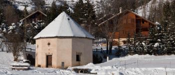
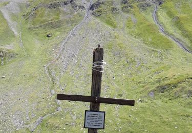
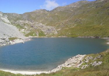
Tocht Sneeuwschoenen van 5,3 km beschikbaar op Provence-Alpes-Côte d'Azur, Hautes-Alpes, Le Monêtier-les-Bains. Deze tocht wordt voorgesteld door aja.
Beschrijving
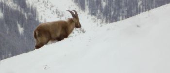
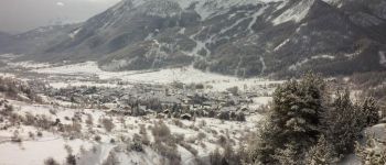
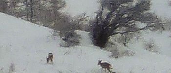
Cette rando offre de belles vues sur la Vallée et le massif de Serre-Chevelier. Avec un peu de chance on y rencontre des chamois et des bouquetins
Plaatsbepaling
Land:
France
Regio :
Provence-Alpes-Côte d'Azur
Departement/Provincie :
Hautes-Alpes
Gemeente :
Le Monêtier-les-Bains
Locatie:
Unknown
Vertrek:(Dec)
Vertrek:(UTM)
303858 ; 4983238 (32T) N.
Opmerkingen
Wandeltochten in de omgeving
![Tocht Stappen Le Monêtier-les-Bains - Le Grand Lac - Photo](https://media.geolcdn.com/t/375/260/ext.jpg?maxdim=2&url=https%3A%2F%2Fservices.sitytrail.com%2FGeolivesWS%2FDownloadMedia.ashx%3FTrailID%3D101251%26Media%3D741_2.jpg)
![Stappen Stappen](https://static1.geolcdn.com/sitytour/trail-icons/101.png)
Le Grand Lac
Stappen
Moeilijk
(2)
Le Monêtier-les-Bains,
Provence-Alpes-Côte d'Azur,
Hautes-Alpes,
France
![](/images/other/stat-length.png)
5,2 km | 12,8 km-effort
5h 0min
![](https://static1.geolcdn.com/siteimages/upload/files/16400158638029165_repeat_loop_refresh_sync_direction_icon.png)
Neen
![Tocht Ski randonnée Le Monêtier-les-Bains - La pointe de L'etandard - Photo](https://media.geolcdn.com/t/375/260/b38baca5-df4e-43d2-ad4d-62353ec9c6be.jpg&format=jpg&maxdim=2)
![Ski randonnée Ski randonnée](https://static1.geolcdn.com/sitytour/trail-icons/503.png)
La pointe de L'etandard
Ski randonnée
Medium
Le Monêtier-les-Bains,
Provence-Alpes-Côte d'Azur,
Hautes-Alpes,
France
![](/images/other/stat-length.png)
9,4 km | 27 km-effort
4h 3min
![](https://static1.geolcdn.com/siteimages/upload/files/16400158638029165_repeat_loop_refresh_sync_direction_icon.png)
Ja
![Tocht Stappen Le Monêtier-les-Bains - 05 col ponsonniere - Photo](https://media.geolcdn.com/t/375/260/732cfff8-bdda-413d-a875-cbedcd33e096.jpg&format=jpg&maxdim=2)
![Stappen Stappen](https://static1.geolcdn.com/sitytour/trail-icons/101.png)
05 col ponsonniere
Stappen
Medium
Le Monêtier-les-Bains,
Provence-Alpes-Côte d'Azur,
Hautes-Alpes,
France
![](/images/other/stat-length.png)
14,4 km | 27 km-effort
6h 25min
![](https://static1.geolcdn.com/siteimages/upload/files/16400158638029165_repeat_loop_refresh_sync_direction_icon.png)
Neen
![Tocht Stappen Le Monêtier-les-Bains - pic est de Combeynot - Photo](https://media.geolcdn.com/t/375/260/eafe3cfc-88ad-4ef2-8553-fd5f300cfc38.jpg&format=jpg&maxdim=2)
![Stappen Stappen](https://static1.geolcdn.com/sitytour/trail-icons/101.png)
pic est de Combeynot
Stappen
Zeer moeilijk
Le Monêtier-les-Bains,
Provence-Alpes-Côte d'Azur,
Hautes-Alpes,
France
![](/images/other/stat-length.png)
13,3 km | 33 km-effort
6h 24min
![](https://static1.geolcdn.com/siteimages/upload/files/16400158638029165_repeat_loop_refresh_sync_direction_icon.png)
Ja
![Tocht Stappen Le Monêtier-les-Bains - l'aiguillette du Lauzet par le grand lac - Photo](https://media.geolcdn.com/t/375/260/047d899e-dac4-4227-82df-970b78e389f9.jpg&format=jpg&maxdim=2)
![Stappen Stappen](https://static1.geolcdn.com/sitytour/trail-icons/101.png)
l'aiguillette du Lauzet par le grand lac
Stappen
Moeilijk
Le Monêtier-les-Bains,
Provence-Alpes-Côte d'Azur,
Hautes-Alpes,
France
![](/images/other/stat-length.png)
13,8 km | 29 km-effort
8h 39min
![](https://static1.geolcdn.com/siteimages/upload/files/16400158638029165_repeat_loop_refresh_sync_direction_icon.png)
Ja
![Tocht Stappen Le Monêtier-les-Bains - Chalet de l'Alpe - Grand lac - Croix 15/08/18 - Photo](https://media.geolcdn.com/t/375/260/7c37172e-8a7f-4341-9586-916674aea659.jpg&format=jpg&maxdim=2)
![Stappen Stappen](https://static1.geolcdn.com/sitytour/trail-icons/101.png)
Chalet de l'Alpe - Grand lac - Croix 15/08/18
Stappen
Medium
Le Monêtier-les-Bains,
Provence-Alpes-Côte d'Azur,
Hautes-Alpes,
France
![](/images/other/stat-length.png)
11,7 km | 22 km-effort
4h 23min
![](https://static1.geolcdn.com/siteimages/upload/files/16400158638029165_repeat_loop_refresh_sync_direction_icon.png)
Ja
![Tocht Via ferrata Le Monêtier-les-Bains - Via ferrata Aiguillette du Lauzet 30/06/18 - Photo](https://media.geolcdn.com/t/375/260/f94c7ee2-184f-466f-9471-9131d6d51143.jpg&format=jpg&maxdim=2)
![Via ferrata Via ferrata](https://static1.geolcdn.com/sitytour/trail-icons/902.png)
Via ferrata Aiguillette du Lauzet 30/06/18
Via ferrata
Medium
Le Monêtier-les-Bains,
Provence-Alpes-Côte d'Azur,
Hautes-Alpes,
France
![](/images/other/stat-length.png)
9,5 km | 21 km-effort
2h 30min
![](https://static1.geolcdn.com/siteimages/upload/files/16400158638029165_repeat_loop_refresh_sync_direction_icon.png)
Ja
![Tocht Stappen Le Monêtier-les-Bains - Haut tour des Cerces - Photo](https://media.geolcdn.com/t/375/260/ext.jpg?maxdim=2&url=https%3A%2F%2Fstatic1.geolcdn.com%2Fsiteimages%2Fupload%2Ffiles%2F1553511878bg_sport_marche.png)
![Stappen Stappen](https://static1.geolcdn.com/sitytour/trail-icons/101.png)
Haut tour des Cerces
Stappen
Zeer moeilijk
(1)
Le Monêtier-les-Bains,
Provence-Alpes-Côte d'Azur,
Hautes-Alpes,
France
![](/images/other/stat-length.png)
42 km | 77 km-effort
15h 27min
![](https://static1.geolcdn.com/siteimages/upload/files/16400158638029165_repeat_loop_refresh_sync_direction_icon.png)
Ja
![Tocht Stappen Le Monêtier-les-Bains - Le grand lac - Photo](https://media.geolcdn.com/t/375/260/ext.jpg?maxdim=2&url=https%3A%2F%2Fservices.sitytrail.com%2FGeolivesWS%2FDownloadMedia.ashx%3FTrailID%3D339755%26Media%3Dfix__20140827123209.jpg)
![Stappen Stappen](https://static1.geolcdn.com/sitytour/trail-icons/101.png)
Le grand lac
Stappen
Medium
Le Monêtier-les-Bains,
Provence-Alpes-Côte d'Azur,
Hautes-Alpes,
France
![](/images/other/stat-length.png)
10,7 km | 20 km-effort
6h 15min
![](https://static1.geolcdn.com/siteimages/upload/files/16400158638029165_repeat_loop_refresh_sync_direction_icon.png)
Ja