![](/images/other/stat-length.png)
![Tocht Stappen Châtenois - Boucle Heidenbuehl - Chapelle du chêne - Photo](https://media.geolcdn.com/t/1900/400/1803ae44-992c-4c84-9ba8-36972f6394ca.jpg&format=pjpeg&maxdim=2)
Boucle Heidenbuehl - Chapelle du chêne
Luster
Gebruiker
![Lengte](/images/other/stat-length.png)
Lengte
5,5 km
![Max. hoogte](https://static1.geolcdn.com/siteimages/upload/files/1508320355ic_sort_altitude_max_24dp.png)
Max. hoogte
315 m
![Positief hoogteverschil](https://static1.geolcdn.com/siteimages/upload/files/1508320355ic_sort_den_pos_24dp.png)
Positief hoogteverschil
129 m
![Km-Effort](/images/other/stat-length.png)
Km-Effort
7,2 km
![Min. hoogte](https://static1.geolcdn.com/siteimages/upload/files/1508320355ic_sort_altitude_min_24dp.png)
Min. hoogte
217 m
![Negatief hoogteverschil](https://static1.geolcdn.com/siteimages/upload/files/1508320355ic_sort_den_neg_24dp.png)
Negatief hoogteverschil
128 m
![Boucle](https://static1.geolcdn.com/siteimages/upload/files/16400158638029165_repeat_loop_refresh_sync_direction_icon.png)
Boucle
Ja
Datum van aanmaak :
2023-10-09 15:28:01.004
Laatste wijziging :
2023-10-09 16:09:48.645
![Stappen](https://static1.geolcdn.com/sitytour/trail-icons/101.png)
1h38
Moeilijkheid : Medium
![Scan deze QR-code om de tocht te openen in de SityTrail-applicatie](https://capi.geolives.com/qq0zvz2zws4bq2lad0pu/sitytour/trails/3834645/qr.png?size=200)
Gratisgps-wandelapplicatie
Over ons
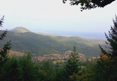
Tocht Stappen van 5,5 km beschikbaar op Grand Est, Bas-Rhin, Châtenois. Deze tocht wordt voorgesteld door Luster.
Beschrijving
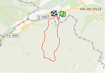
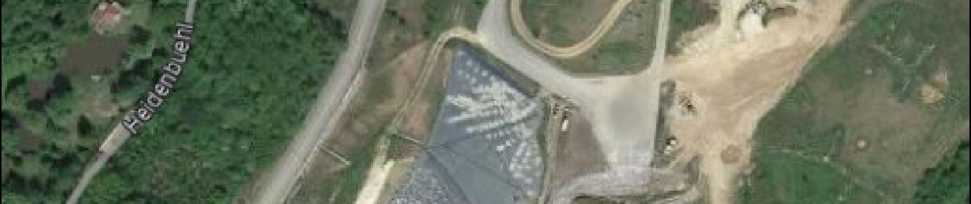
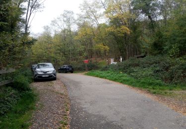
Boucle de 5,5 km, km-effort 7,2 km dénivelé de 128 m temps 1 heure 55. Entrée chemin Heidenbuehl 100 m après SMICOM et possibilité de garer la voiture à 200 m.
Plaatsbepaling
Land:
France
Regio :
Grand Est
Departement/Provincie :
Bas-Rhin
Gemeente :
Châtenois
Locatie:
Unknown
Vertrek:(Dec)
Vertrek:(UTM)
378732 ; 5348576 (32U) N.
Opmerkingen
Wandeltochten in de omgeving
![Tocht Stappen Châtenois - Le Hahnenberg et les balcons Sélestat - Photo](https://media.geolcdn.com/t/375/260/ext.jpg?maxdim=2&url=https%3A%2F%2Fservices.sitytrail.com%2FGeolivesWS%2FDownloadMedia.ashx%3FTrailID%3D160509%26Media%3D20121030151326.jpeg)
![Stappen Stappen](https://static1.geolcdn.com/sitytour/trail-icons/101.png)
Le Hahnenberg et les balcons Sélestat
Stappen
Medium
(2)
Châtenois,
Grand Est,
Bas-Rhin,
France
![](/images/other/stat-length.png)
12 km | 17,2 km-effort
4h 29min
![](https://static1.geolcdn.com/siteimages/upload/files/16400158638029165_repeat_loop_refresh_sync_direction_icon.png)
Ja
![Tocht Stappen Scherwiller - chateau de ortenbourg - Photo](https://media.geolcdn.com/t/375/260/ext.jpg?maxdim=2&url=https%3A%2F%2Fstatic1.geolcdn.com%2Fsiteimages%2Fupload%2Ffiles%2F1553511878bg_sport_marche.png)
![Stappen Stappen](https://static1.geolcdn.com/sitytour/trail-icons/101.png)
chateau de ortenbourg
Stappen
Heel gemakkelijk
(1)
Scherwiller,
Grand Est,
Bas-Rhin,
France
![](/images/other/stat-length.png)
4,6 km | 7,9 km-effort
1h 29min
![](https://static1.geolcdn.com/siteimages/upload/files/16400158638029165_repeat_loop_refresh_sync_direction_icon.png)
Ja
![Tocht Stappen Châtenois - Le Haut Koenigsbourg de Val de Ville - Photo](https://media.geolcdn.com/t/375/260/ext.jpg?maxdim=2&url=https%3A%2F%2Fservices.sitytrail.com%2FGeolivesWS%2FDownloadMedia.ashx%3FTrailID%3D101918%26Media%3D2205_1.jpg)
![Stappen Stappen](https://static1.geolcdn.com/sitytour/trail-icons/101.png)
Le Haut Koenigsbourg de Val de Ville
Stappen
Moeilijk
(1)
Châtenois,
Grand Est,
Bas-Rhin,
France
![](/images/other/stat-length.png)
16,8 km | 25 km-effort
5h 0min
![](https://static1.geolcdn.com/siteimages/upload/files/16400158638029165_repeat_loop_refresh_sync_direction_icon.png)
Ja
![Tocht Mountainbike Thanvillé - Circuit de la Gadouille - Photo](https://media.geolcdn.com/t/375/260/ext.jpg?maxdim=2&url=https%3A%2F%2Fservices.sitytrail.com%2FGeolivesWS%2FDownloadMedia.ashx%3FTrailID%3D101135%26Media%3D622_1.jpg)
![Mountainbike Mountainbike](https://static1.geolcdn.com/sitytour/trail-icons/202.png)
Circuit de la Gadouille
Mountainbike
Moeilijk
(3)
Thanvillé,
Grand Est,
Bas-Rhin,
France
![](/images/other/stat-length.png)
18,4 km | 27 km-effort
1h 40min
![](https://static1.geolcdn.com/siteimages/upload/files/16400158638029165_repeat_loop_refresh_sync_direction_icon.png)
Ja
![Tocht Stappen Kintzheim - suuntoapp-Hiking-2023-10-15T07-53-44Z - Photo](https://media.geolcdn.com/t/375/260/10137816-bbc2-48a8-ba49-81d776e456aa.jpg&format=jpg&maxdim=2)
![Stappen Stappen](https://static1.geolcdn.com/sitytour/trail-icons/101.png)
suuntoapp-Hiking-2023-10-15T07-53-44Z
Stappen
Medium
Kintzheim,
Grand Est,
Bas-Rhin,
France
![](/images/other/stat-length.png)
18,5 km | 28 km-effort
6h 16min
![](https://static1.geolcdn.com/siteimages/upload/files/16400158638029165_repeat_loop_refresh_sync_direction_icon.png)
Ja
![Tocht Stappen La Vancelle - 2020-05-21 Marche La Vancelle Boucle - Photo](https://media.geolcdn.com/t/375/260/45f73326-854e-41a0-95ea-dc1c83334d8a.jpg&format=jpg&maxdim=2)
![Stappen Stappen](https://static1.geolcdn.com/sitytour/trail-icons/101.png)
2020-05-21 Marche La Vancelle Boucle
Stappen
Heel gemakkelijk
La Vancelle,
Grand Est,
Bas-Rhin,
France
![](/images/other/stat-length.png)
16,3 km | 26 km-effort
6h 41min
![](https://static1.geolcdn.com/siteimages/upload/files/16400158638029165_repeat_loop_refresh_sync_direction_icon.png)
Ja
![Tocht Stappen La Vancelle - 2015-01-02 Marche Rocher du Coucou Chateau Frankenbourg - Photo](https://media.geolcdn.com/t/375/260/ext.jpg?maxdim=2&url=https%3A%2F%2Fstatic1.geolcdn.com%2Fsiteimages%2Fupload%2Ffiles%2F1553511878bg_sport_marche.png)
![Stappen Stappen](https://static1.geolcdn.com/sitytour/trail-icons/101.png)
2015-01-02 Marche Rocher du Coucou Chateau Frankenbourg
Stappen
Gemakkelijk
(1)
La Vancelle,
Grand Est,
Bas-Rhin,
France
![](/images/other/stat-length.png)
10,9 km | 18,1 km-effort
3h 47min
![](https://static1.geolcdn.com/siteimages/upload/files/16400158638029165_repeat_loop_refresh_sync_direction_icon.png)
Ja
![Tocht Mountainbike Bergheim - 1 ère sortie - Photo](https://media.geolcdn.com/t/375/260/57e3216c-710e-4acb-980c-a1a007f80923.jpg&format=jpg&maxdim=2)
![Mountainbike Mountainbike](https://static1.geolcdn.com/sitytour/trail-icons/202.png)
1 ère sortie
Mountainbike
Gemakkelijk
Bergheim,
Grand Est,
Haut-Rhin,
France
![](/images/other/stat-length.png)
12,6 km | 19,1 km-effort
1h 53min
![](https://static1.geolcdn.com/siteimages/upload/files/16400158638029165_repeat_loop_refresh_sync_direction_icon.png)
Ja
![Tocht Stappen Scherwiller - Scherwiller - Chateaux Ramstein-Ortenbourg-Berstein 2022-10 - Photo](https://media.geolcdn.com/t/375/260/2163c1a8-b02b-4f2c-aaa3-de2f4e89bdfa.jpg&format=jpg&maxdim=2)
![Stappen Stappen](https://static1.geolcdn.com/sitytour/trail-icons/101.png)
Scherwiller - Chateaux Ramstein-Ortenbourg-Berstein 2022-10
Stappen
Gemakkelijk
Scherwiller,
Grand Est,
Bas-Rhin,
France
![](/images/other/stat-length.png)
14,5 km | 22 km-effort
3h 13min
![](https://static1.geolcdn.com/siteimages/upload/files/16400158638029165_repeat_loop_refresh_sync_direction_icon.png)
Ja