![](/images/other/stat-length.png)
![Tocht Wintersport Montperreux - la Fluvelle - Photo](https://media.geolcdn.com/t/1900/400/ext.pjpeg?maxdim=2&url=https%3A%2F%2Fstatic1.geolcdn.com%2Fsiteimages%2Fupload%2Ffiles%2F1524743153ski.jpg)
la Fluvelle
fredhd25
Gebruiker
![Lengte](/images/other/stat-length.png)
Lengte
13,5 km
![Max. hoogte](https://static1.geolcdn.com/siteimages/upload/files/1508320355ic_sort_altitude_max_24dp.png)
Max. hoogte
1094 m
![Positief hoogteverschil](https://static1.geolcdn.com/siteimages/upload/files/1508320355ic_sort_den_pos_24dp.png)
Positief hoogteverschil
268 m
![Km-Effort](/images/other/stat-length.png)
Km-Effort
17,1 km
![Min. hoogte](https://static1.geolcdn.com/siteimages/upload/files/1508320355ic_sort_altitude_min_24dp.png)
Min. hoogte
1008 m
![Negatief hoogteverschil](https://static1.geolcdn.com/siteimages/upload/files/1508320355ic_sort_den_neg_24dp.png)
Negatief hoogteverschil
268 m
![Boucle](https://static1.geolcdn.com/siteimages/upload/files/16400158638029165_repeat_loop_refresh_sync_direction_icon.png)
Boucle
Ja
Datum van aanmaak :
2015-02-04 00:00:00.0
Laatste wijziging :
2015-02-04 00:00:00.0
![Wintersport](https://static1.geolcdn.com/sitytour/trail-icons/500.png)
1h09
Moeilijkheid : Medium
![Scan deze QR-code om de tocht te openen in de SityTrail-applicatie](https://capi.geolives.com/qq0zvz2zws4bq2lad0pu/sitytour/trails/383273/qr.png?size=200)
Gratisgps-wandelapplicatie
Over ons
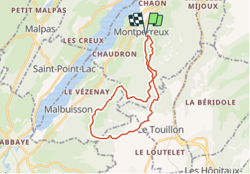
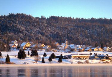
Tocht Wintersport van 13,5 km beschikbaar op Bourgondië-Franche-Comté, Doubs, Montperreux. Deze tocht wordt voorgesteld door fredhd25.
Beschrijving
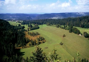
Départ Montperreux - Suivre Piste noire La Fuvelle - tres beau parcours avec vue sur Métabief / Mont d'Or et les Alpes par temps dégagé.
Plaatsbepaling
Land:
France
Regio :
Bourgondië-Franche-Comté
Departement/Provincie :
Doubs
Gemeente :
Montperreux
Locatie:
Unknown
Vertrek:(Dec)
Vertrek:(UTM)
297305 ; 5189038 (32T) N.
Opmerkingen
Wandeltochten in de omgeving
![Tocht Stappen Les Fourgs - Le Stratégique - Doubs - Photo](https://media.geolcdn.com/t/375/260/ext.jpg?maxdim=2&url=https%3A%2F%2Fservices.sitytrail.com%2FGeolivesWS%2FDownloadMedia.ashx%3FTrailID%3D108935%26Media%3D2626_1.jpg)
![Stappen Stappen](https://static1.geolcdn.com/sitytour/trail-icons/101.png)
Le Stratégique - Doubs
Stappen
Medium
(1)
Les Fourgs,
Bourgondië-Franche-Comté,
Doubs,
France
![](/images/other/stat-length.png)
8,3 km | 10,6 km-effort
2h 45min
![](https://static1.geolcdn.com/siteimages/upload/files/16400158638029165_repeat_loop_refresh_sync_direction_icon.png)
Ja
![Tocht Stappen Les Fourgs - 2024-01-31_00h34m12_le-belvedere-de-la-roche-sarrasine_randonnee-2285212 - Photo](https://media.geolcdn.com/t/375/260/ext.jpg?maxdim=2&url=https%3A%2F%2Fstatic1.geolcdn.com%2Fsiteimages%2Fupload%2Ffiles%2F1553511878bg_sport_marche.png)
![Stappen Stappen](https://static1.geolcdn.com/sitytour/trail-icons/101.png)
2024-01-31_00h34m12_le-belvedere-de-la-roche-sarrasine_randonnee-2285212
Stappen
Moeilijk
(1)
Les Fourgs,
Bourgondië-Franche-Comté,
Doubs,
France
![](/images/other/stat-length.png)
12,4 km | 17 km-effort
3h 51min
![](https://static1.geolcdn.com/siteimages/upload/files/16400158638029165_repeat_loop_refresh_sync_direction_icon.png)
Ja
![Tocht Stappen Saint-Antoine - Boucle du fort St Antoine - Photo](https://media.geolcdn.com/t/375/260/39387965-6cd2-4b9c-a9a7-b089cab08bc2.jpg&format=jpg&maxdim=2)
![Stappen Stappen](https://static1.geolcdn.com/sitytour/trail-icons/101.png)
Boucle du fort St Antoine
Stappen
Medium
Saint-Antoine,
Bourgondië-Franche-Comté,
Doubs,
France
![](/images/other/stat-length.png)
4,8 km | 6,2 km-effort
1h 25min
![](https://static1.geolcdn.com/siteimages/upload/files/16400158638029165_repeat_loop_refresh_sync_direction_icon.png)
Ja
![Tocht Te voet Saint-Point-Lac - La Ronde des Deux Villages - Photo](https://media.geolcdn.com/t/375/260/0971416a-a891-44ca-98b1-126d1c5a4069.jpeg&format=jpg&maxdim=2)
![Te voet Te voet](https://static1.geolcdn.com/sitytour/trail-icons/100.png)
La Ronde des Deux Villages
Te voet
Gemakkelijk
Saint-Point-Lac,
Bourgondië-Franche-Comté,
Doubs,
France
![](/images/other/stat-length.png)
5,5 km | 7,3 km-effort
1h 40min
![](https://static1.geolcdn.com/siteimages/upload/files/16400158638029165_repeat_loop_refresh_sync_direction_icon.png)
Ja
![Tocht Te voet Les Grangettes - La Pierre qui Tourne - Photo](https://media.geolcdn.com/t/375/260/9bc03250-aa40-4533-aaa8-f54e2fea6187.jpeg&format=jpg&maxdim=2)
![Te voet Te voet](https://static1.geolcdn.com/sitytour/trail-icons/100.png)
La Pierre qui Tourne
Te voet
Gemakkelijk
Les Grangettes,
Bourgondië-Franche-Comté,
Doubs,
France
![](/images/other/stat-length.png)
8,2 km | 10,7 km-effort
2h 25min
![](https://static1.geolcdn.com/siteimages/upload/files/16400158638029165_repeat_loop_refresh_sync_direction_icon.png)
Ja
![Tocht Te voet Malpas - Le Tour du Lac de Malpas - Photo](https://media.geolcdn.com/t/375/260/0837636c-66a1-4405-831a-9c313453c2cb.jpeg&format=jpg&maxdim=2)
![Te voet Te voet](https://static1.geolcdn.com/sitytour/trail-icons/100.png)
Le Tour du Lac de Malpas
Te voet
Gemakkelijk
Malpas,
Bourgondië-Franche-Comté,
Doubs,
France
![](/images/other/stat-length.png)
4,9 km | 5,7 km-effort
1h 17min
![](https://static1.geolcdn.com/siteimages/upload/files/16400158638029165_repeat_loop_refresh_sync_direction_icon.png)
Ja
![Tocht Te voet Malbuisson - Sentier du Tour du Lac - Photo](https://media.geolcdn.com/t/375/260/ec9f6be9-4d56-4db2-b65f-5890444a2963.jpeg&format=jpg&maxdim=2)
![Te voet Te voet](https://static1.geolcdn.com/sitytour/trail-icons/100.png)
Sentier du Tour du Lac
Te voet
Gemakkelijk
Malbuisson,
Bourgondië-Franche-Comté,
Doubs,
France
![](/images/other/stat-length.png)
16 km | 19,9 km-effort
4h 30min
![](https://static1.geolcdn.com/siteimages/upload/files/16400158638029165_repeat_loop_refresh_sync_direction_icon.png)
Neen
![Tocht Noords wandelen Malbuisson - Fort St Antoine - Photo](https://media.geolcdn.com/t/375/260/fe4e7a22-394a-4da9-be49-1254fdb85bde.jpg&format=jpg&maxdim=2)
![Noords wandelen Noords wandelen](https://static1.geolcdn.com/sitytour/trail-icons/102.png)
Fort St Antoine
Noords wandelen
Gemakkelijk
Malbuisson,
Bourgondië-Franche-Comté,
Doubs,
France
![](/images/other/stat-length.png)
5,8 km | 7,3 km-effort
2h 21min
![](https://static1.geolcdn.com/siteimages/upload/files/16400158638029165_repeat_loop_refresh_sync_direction_icon.png)
Ja
![Tocht Langlaufen Les Hôpitaux-Vieux - Les Essarts - Photo](https://media.geolcdn.com/t/375/260/133bf42f-84e7-4637-b480-7581e8a779ca.jpg&format=jpg&maxdim=2)
![Langlaufen Langlaufen](https://static1.geolcdn.com/sitytour/trail-icons/502.png)
Les Essarts
Langlaufen
Gemakkelijk
Les Hôpitaux-Vieux,
Bourgondië-Franche-Comté,
Doubs,
France
![](/images/other/stat-length.png)
6,5 km | 8,1 km-effort
2h 3min
![](https://static1.geolcdn.com/siteimages/upload/files/16400158638029165_repeat_loop_refresh_sync_direction_icon.png)
Ja