![](/images/other/stat-length.png)
![Tocht Stappen Toulon - faron Daniel Louis sud et sommet - Photo](https://media.geolcdn.com/t/1900/400/fb0188af-d2a0-4724-8d2f-cef38c8117be.jpg&format=pjpeg&maxdim=2)
faron Daniel Louis sud et sommet
cdanielrando
Gebruiker
![Lengte](/images/other/stat-length.png)
![Max. hoogte](https://static1.geolcdn.com/siteimages/upload/files/1508320355ic_sort_altitude_max_24dp.png)
![Positief hoogteverschil](https://static1.geolcdn.com/siteimages/upload/files/1508320355ic_sort_den_pos_24dp.png)
![Km-Effort](/images/other/stat-length.png)
![Min. hoogte](https://static1.geolcdn.com/siteimages/upload/files/1508320355ic_sort_altitude_min_24dp.png)
![Negatief hoogteverschil](https://static1.geolcdn.com/siteimages/upload/files/1508320355ic_sort_den_neg_24dp.png)
![Boucle](https://static1.geolcdn.com/siteimages/upload/files/16400158638029165_repeat_loop_refresh_sync_direction_icon.png)
![Stappen](https://static1.geolcdn.com/sitytour/trail-icons/101.png)
2h41
Moeilijkheid : Medium
![Scan deze QR-code om de tocht te openen in de SityTrail-applicatie](https://capi.geolives.com/qq0zvz2zws4bq2lad0pu/sitytour/trails/3830435/qr.png?size=200)
Gratisgps-wandelapplicatie
Over ons
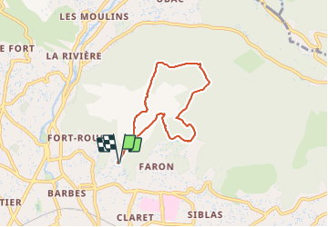
Tocht Stappen van 6,4 km beschikbaar op Provence-Alpes-Côte d'Azur, Var, Toulon. Deze tocht wordt voorgesteld door cdanielrando.
Beschrijving
Départ arrivée sur la route au lieu dit " les balcons du Faron ". Dès le départ, une montée assez raide jusqu'au mémorial et ensuite le parcours facile sur la crête permet de regarder vers le nord avec vue sur le barrage du Revest , le zoo , le point sublime qui porte bien son nom, et passage sous les câbles du téléphérique à l'endroit où se croisent les cabines.
Plaatsbepaling
Opmerkingen
Wandeltochten in de omgeving
![Tocht Stappen Ollioules - SityTrail - 1041295 - le-destel-grotte-des-joncs - Photo](https://media.geolcdn.com/t/375/260/b00c002a-3425-4f84-ae24-7620ef9e7315.jpg&format=jpg&maxdim=2)
![Stappen Stappen](https://static1.geolcdn.com/sitytour/trail-icons/101.png)
Stappen
![](/images/other/stat-length.png)
![](https://static1.geolcdn.com/siteimages/upload/files/16400158638029165_repeat_loop_refresh_sync_direction_icon.png)
![Tocht Stappen Le Revest-les-Eaux - Boucle: La ripelle - Source de la ripelle - Le Chateau de Tourris - Les grottes de sable - La carrière aux fourmis - Les puits renovés de M. Lambicchi - Les ruines des Olivières - La ferme de la Touravelle - à Le Revest-les-Eaux - Photo](https://media.geolcdn.com/t/375/260/0dbff04b-2a84-4eed-a6e8-7a56bc074382.jpg&format=jpg&maxdim=2)
![Stappen Stappen](https://static1.geolcdn.com/sitytour/trail-icons/101.png)
Stappen
![](/images/other/stat-length.png)
![](https://static1.geolcdn.com/siteimages/upload/files/16400158638029165_repeat_loop_refresh_sync_direction_icon.png)
![Tocht Stappen Toulon - Faron versant Nord - Photo](https://media.geolcdn.com/t/375/260/40a1f88d-10a7-4595-84a1-0086eecb7f84.jpg&format=jpg&maxdim=2)
![Stappen Stappen](https://static1.geolcdn.com/sitytour/trail-icons/101.png)
Stappen
![](/images/other/stat-length.png)
![](https://static1.geolcdn.com/siteimages/upload/files/16400158638029165_repeat_loop_refresh_sync_direction_icon.png)
![Tocht Stappen Toulon - Faron côté nord - Photo](https://media.geolcdn.com/t/375/260/1a97f987-c174-4fc8-a435-d00586c57288.jpg&format=jpg&maxdim=2)
![Stappen Stappen](https://static1.geolcdn.com/sitytour/trail-icons/101.png)
Stappen
![](/images/other/stat-length.png)
![](https://static1.geolcdn.com/siteimages/upload/files/16400158638029165_repeat_loop_refresh_sync_direction_icon.png)
![Tocht Stappen Le Revest-les-Eaux - 83 barrage revest les eaux 24-05-2021 - Photo](https://media.geolcdn.com/t/375/260/1106c6f7-fedf-4077-96a1-b48580038b53.jpg&format=jpg&maxdim=2)
![Stappen Stappen](https://static1.geolcdn.com/sitytour/trail-icons/101.png)
Stappen
![](/images/other/stat-length.png)
![](https://static1.geolcdn.com/siteimages/upload/files/16400158638029165_repeat_loop_refresh_sync_direction_icon.png)
![Tocht Stappen La Valette-du-Var - SityTrail - Le tour du coudon - Photo](https://media.geolcdn.com/t/375/260/c1a593ce-5178-4a51-a2b4-9401a3556db4.jpg&format=jpg&maxdim=2)
![Stappen Stappen](https://static1.geolcdn.com/sitytour/trail-icons/101.png)
Stappen
![](/images/other/stat-length.png)
![](https://static1.geolcdn.com/siteimages/upload/files/16400158638029165_repeat_loop_refresh_sync_direction_icon.png)
![Tocht Stappen Toulon - Tour Du Baou par falaises - Photo](https://media.geolcdn.com/t/375/260/ext.jpg?maxdim=2&url=https%3A%2F%2Fservices.sitytrail.com%2FGeolivesWS%2FDownloadMedia.ashx%3FTrailID%3D166161%26Media%3D20121215151840.jpeg)
![Stappen Stappen](https://static1.geolcdn.com/sitytour/trail-icons/101.png)
Stappen
![](/images/other/stat-length.png)
![](https://static1.geolcdn.com/siteimages/upload/files/16400158638029165_repeat_loop_refresh_sync_direction_icon.png)
![Tocht Stappen Évenos - Le broussan croupatier fin randonnée - Photo](https://media.geolcdn.com/t/375/260/ec3fd25e-452d-47c7-8bcf-accd29bcb68e.jpg&format=jpg&maxdim=2)
![Stappen Stappen](https://static1.geolcdn.com/sitytour/trail-icons/101.png)
Stappen
![](/images/other/stat-length.png)
![](https://static1.geolcdn.com/siteimages/upload/files/16400158638029165_repeat_loop_refresh_sync_direction_icon.png)
![Tocht Stappen Le Revest-les-Eaux - Boucle: Ripelle - Touravelle - Ruines des olivieres - Carrière aux fourmis - Grottes de sables - Vieille valette - Tourris - Source - Ripelle - Photo](https://media.geolcdn.com/t/375/260/ext.jpg?maxdim=2&url=https%3A%2F%2Fstatic1.geolcdn.com%2Fsiteimages%2Fupload%2Ffiles%2F1553511878bg_sport_marche.png)
![Stappen Stappen](https://static1.geolcdn.com/sitytour/trail-icons/101.png)
Stappen
![](/images/other/stat-length.png)
![](https://static1.geolcdn.com/siteimages/upload/files/16400158638029165_repeat_loop_refresh_sync_direction_icon.png)