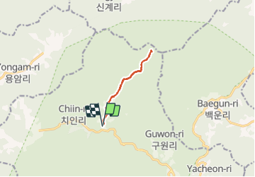
Tocht Stappen Unknown - Peak Sangwangbong  - Photo
 dudu42
dudu42

Gebruiker

© OpenStreetMap contributors
Lengte
Lengte
11,1 km
Max. hoogte
Max. hoogte
1338 m
Positief hoogteverschil
787 m
Km-Effort
Km-Effort  
22 km
Min. hoogte
Min. hoogte
545 m
Negatief hoogteverschil
787 m
Boucle
Boucle
Ja
Datum van aanmaak :
2023-09-27 00:53:38.632
Laatste wijziging :
2023-09-27 06:52:34.669

(0 Bericht)

Stappen
Stappen
4h18
Moeilijkheid : Moeilijk

Scan deze QR-code om de tocht te openen in de SityTrail-applicatie

Gratisgps-wandelapplicatie

Logo SityTrail SityTrail

IGN / Geografische instituten

SityTrail uit de App Store downloaden SityTrail uit Google Play downloaden

Logo SityTrail SityTrail World

De wereld gaat voor u open

SityTrail uit de App Store downloaden SityTrail uit Google Play downloaden SityTrail op Huawei AppGallery downloaden

Over ons

Tocht Stappen van 11,1 km beschikbaar op Gyeongsangnam-do, 합천군. Deze tocht wordt voorgesteld door dudu42.

Beschrijving

Parcours agréable en sous bois le long du torrent. Chemin de terre au début puis marches en pierre alternant avec des escaliers en bois. Montée régulière puis accentuation de la pente vers la fin. Belle vue panoramique si le temps le permet !. Au retour , n'oubliez pas de visiter le temple.
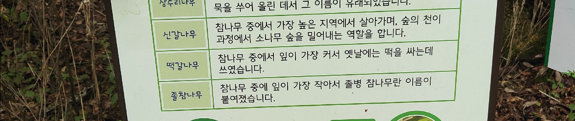
Hoogteprofiel

Foto's

30 fotos in totaal. Klik op een foto om ze allemaal in de galerij weer te geven.

Plaatsbepaling

Land:
Korea, Republic of
Regio :
Gyeongsangnam-do
Departement/Provincie :
합천군
Gemeente :
Unknown
Locatie:
Unknown
Vertrek:(UTM)
418160 ; 3961452 (52S) N.

Wandeltochten in de omgeving


Sluiten
Mijn abonnementen