![](/images/other/stat-length.png)
![Tocht Te voet Gournay - Circuit pédestre n°37](https://media.geolcdn.com/t/1900/400/ext.pjpeg?maxdim=2&url=https%3A%2F%2Fstatic1.geolcdn.com%2Fsiteimages%2Fupload%2Ffiles%2F1545311037marcheuse_200dpi.jpg)
Circuit pédestre n°37 "le patrimoine bâti de st julien à st abdon"
fanthou
Gebruiker
![Lengte](/images/other/stat-length.png)
Lengte
5,8 km
![Max. hoogte](https://static1.geolcdn.com/siteimages/upload/files/1508320355ic_sort_altitude_max_24dp.png)
Max. hoogte
230 m
![Positief hoogteverschil](https://static1.geolcdn.com/siteimages/upload/files/1508320355ic_sort_den_pos_24dp.png)
Positief hoogteverschil
90 m
![Km-Effort](/images/other/stat-length.png)
Km-Effort
7 km
![Min. hoogte](https://static1.geolcdn.com/siteimages/upload/files/1508320355ic_sort_altitude_min_24dp.png)
Min. hoogte
183 m
![Negatief hoogteverschil](https://static1.geolcdn.com/siteimages/upload/files/1508320355ic_sort_den_neg_24dp.png)
Negatief hoogteverschil
92 m
![Boucle](https://static1.geolcdn.com/siteimages/upload/files/16400158638029165_repeat_loop_refresh_sync_direction_icon.png)
Boucle
Ja
Datum van aanmaak :
2023-09-26 08:52:16.37
Laatste wijziging :
2023-09-26 08:52:44.907
![Te voet](https://static1.geolcdn.com/sitytour/trail-icons/100.png)
1h35
Moeilijkheid : Gemakkelijk
![Scan deze QR-code om de tocht te openen in de SityTrail-applicatie](https://capi.geolives.com/qq0zvz2zws4bq2lad0pu/sitytour/trails/3818779/qr.png?size=200)
Gratisgps-wandelapplicatie
Over ons
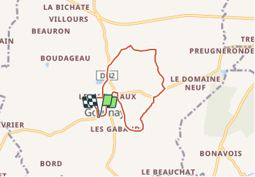
Tocht Te voet van 5,8 km beschikbaar op Centre-Val de Loire, Indre, Gournay. Deze tocht wordt voorgesteld door fanthou.
Beschrijving
Balade dans le village dynamique de Gournay dont la volonté de développement est très forte. C'est un circuit agréable au cœur du bocage idéal pour digérer le repas dominical.
Plaatsbepaling
Land:
France
Regio :
Centre-Val de Loire
Departement/Provincie :
Indre
Gemeente :
Gournay
Locatie:
Unknown
Vertrek:(Dec)
Vertrek:(UTM)
402710 ; 5159531 (31T) N.
Opmerkingen
Wandeltochten in de omgeving
![Tocht Stappen Cluis - Compostelle etape 12 - Photo](https://media.geolcdn.com/t/375/260/943ab30c-06db-400b-8900-4789846364df.jpg&format=jpg&maxdim=2)
![Stappen Stappen](https://static1.geolcdn.com/sitytour/trail-icons/101.png)
Compostelle etape 12
Stappen
Gemakkelijk
Cluis,
Centre-Val de Loire,
Indre,
France
![](/images/other/stat-length.png)
18,2 km | 21 km-effort
19h 6min
![](https://static1.geolcdn.com/siteimages/upload/files/16400158638029165_repeat_loop_refresh_sync_direction_icon.png)
Neen
![Tocht Stappen Cluis - Circuit de Cluis - Photo](https://media.geolcdn.com/t/375/260/ext.jpg?maxdim=2&url=https%3A%2F%2Fservices.sitytrail.com%2FGeolivesWS%2FDownloadMedia.ashx%3FTrailID%3D111738%26Media%3D8140_5.jpg)
![Stappen Stappen](https://static1.geolcdn.com/sitytour/trail-icons/101.png)
Circuit de Cluis
Stappen
Moeilijk
Cluis,
Centre-Val de Loire,
Indre,
France
![](/images/other/stat-length.png)
15,2 km | 17,9 km-effort
3h 49min
![](https://static1.geolcdn.com/siteimages/upload/files/16400158638029165_repeat_loop_refresh_sync_direction_icon.png)
Ja
![Tocht Stappen Cluis - Cluis-Villemort-Cluis - Photo](https://media.geolcdn.com/t/375/260/9afcea35-f85e-43d9-a364-0df58a6dce70.jpg&format=jpg&maxdim=2)
![Stappen Stappen](https://static1.geolcdn.com/sitytour/trail-icons/101.png)
Cluis-Villemort-Cluis
Stappen
Zeer moeilijk
Cluis,
Centre-Val de Loire,
Indre,
France
![](/images/other/stat-length.png)
33 km | 39 km-effort
6h 38min
![](https://static1.geolcdn.com/siteimages/upload/files/16400158638029165_repeat_loop_refresh_sync_direction_icon.png)
Ja
![Tocht Stappen Cluis - Circuit pédestre n° 14](https://media.geolcdn.com/t/375/260/ext.jpg?maxdim=2&url=https%3A%2F%2Fstatic1.geolcdn.com%2Fsiteimages%2Fupload%2Ffiles%2F1553511878bg_sport_marche.png)
![Stappen Stappen](https://static1.geolcdn.com/sitytour/trail-icons/101.png)
Circuit pédestre n° 14 "a toute vapeur"
Stappen
Medium
Cluis,
Centre-Val de Loire,
Indre,
France
![](/images/other/stat-length.png)
7,5 km | 9,4 km-effort
2h 7min
![](https://static1.geolcdn.com/siteimages/upload/files/16400158638029165_repeat_loop_refresh_sync_direction_icon.png)
Ja
![Tocht Paard Maillet - Autour de Maillet (36) - Photo](https://media.geolcdn.com/t/375/260/ext.jpg?maxdim=2&url=https%3A%2F%2Fstatic1.geolcdn.com%2Fsiteimages%2Fupload%2Ffiles%2F1524743154cheval.jpg)
![Paard Paard](https://static1.geolcdn.com/sitytour/trail-icons/300.png)
Autour de Maillet (36)
Paard
Gemakkelijk
Maillet,
Centre-Val de Loire,
Indre,
France
![](/images/other/stat-length.png)
26 km | 30 km-effort
3h 46min
![](https://static1.geolcdn.com/siteimages/upload/files/16400158638029165_repeat_loop_refresh_sync_direction_icon.png)
Ja
![Tocht Stappen Bouesse - Chemin de César (BOUESSE° - Photo](https://media.geolcdn.com/t/375/260/ext.jpg?maxdim=2&url=https%3A%2F%2Fstatic1.geolcdn.com%2Fsiteimages%2Fupload%2Ffiles%2F1553511878bg_sport_marche.png)
![Stappen Stappen](https://static1.geolcdn.com/sitytour/trail-icons/101.png)
Chemin de César (BOUESSE°
Stappen
Medium
Bouesse,
Centre-Val de Loire,
Indre,
France
![](/images/other/stat-length.png)
9,6 km | 10,6 km-effort
2h 24min
![](https://static1.geolcdn.com/siteimages/upload/files/16400158638029165_repeat_loop_refresh_sync_direction_icon.png)
Ja
![Tocht Stappen Cluis - 19 juillet 2021 - Photo](https://media.geolcdn.com/t/375/260/ext.jpg?maxdim=2&url=https%3A%2F%2Fstatic1.geolcdn.com%2Fsiteimages%2Fupload%2Ffiles%2F1553511878bg_sport_marche.png)
![Stappen Stappen](https://static1.geolcdn.com/sitytour/trail-icons/101.png)
19 juillet 2021
Stappen
Zeer moeilijk
Cluis,
Centre-Val de Loire,
Indre,
France
![](/images/other/stat-length.png)
30 km | 36 km-effort
6h 3min
![](https://static1.geolcdn.com/siteimages/upload/files/16400158638029165_repeat_loop_refresh_sync_direction_icon.png)
Ja
![Tocht Stappen Cluis - Cluis Eguzon - Photo](https://media.geolcdn.com/t/375/260/ext.jpg?maxdim=2&url=https%3A%2F%2Fstatic1.geolcdn.com%2Fsiteimages%2Fupload%2Ffiles%2F1553511878bg_sport_marche.png)
![Stappen Stappen](https://static1.geolcdn.com/sitytour/trail-icons/101.png)
Cluis Eguzon
Stappen
Medium
Cluis,
Centre-Val de Loire,
Indre,
France
![](/images/other/stat-length.png)
26 km | 32 km-effort
6h 7min
![](https://static1.geolcdn.com/siteimages/upload/files/16400158638029165_repeat_loop_refresh_sync_direction_icon.png)
Neen
![Tocht Stappen Cluis - Lundi 19 avril 2021 - Photo](https://media.geolcdn.com/t/375/260/ext.jpg?maxdim=2&url=https%3A%2F%2Fstatic1.geolcdn.com%2Fsiteimages%2Fupload%2Ffiles%2F1553511878bg_sport_marche.png)
![Stappen Stappen](https://static1.geolcdn.com/sitytour/trail-icons/101.png)
Lundi 19 avril 2021
Stappen
Moeilijk
Cluis,
Centre-Val de Loire,
Indre,
France
![](/images/other/stat-length.png)
12,7 km | 15,1 km-effort
2h 45min
![](https://static1.geolcdn.com/siteimages/upload/files/16400158638029165_repeat_loop_refresh_sync_direction_icon.png)
Neen