![](/images/other/stat-length.png)
![Tocht Stappen Crozon-sur-Vauvre - Circuit pédestre](https://media.geolcdn.com/t/1900/400/ext.pjpeg?maxdim=2&url=https%3A%2F%2Fstatic1.geolcdn.com%2Fsiteimages%2Fupload%2Ffiles%2F1553511878bg_sport_marche.png)
Circuit pédestre "sortilèges et légendes"
fanthou
Gebruiker
![Lengte](/images/other/stat-length.png)
Lengte
11,3 km
![Max. hoogte](https://static1.geolcdn.com/siteimages/upload/files/1508320355ic_sort_altitude_max_24dp.png)
Max. hoogte
373 m
![Positief hoogteverschil](https://static1.geolcdn.com/siteimages/upload/files/1508320355ic_sort_den_pos_24dp.png)
Positief hoogteverschil
210 m
![Km-Effort](/images/other/stat-length.png)
Km-Effort
14,1 km
![Min. hoogte](https://static1.geolcdn.com/siteimages/upload/files/1508320355ic_sort_altitude_min_24dp.png)
Min. hoogte
273 m
![Negatief hoogteverschil](https://static1.geolcdn.com/siteimages/upload/files/1508320355ic_sort_den_neg_24dp.png)
Negatief hoogteverschil
210 m
![Boucle](https://static1.geolcdn.com/siteimages/upload/files/16400158638029165_repeat_loop_refresh_sync_direction_icon.png)
Boucle
Ja
Datum van aanmaak :
2023-09-26 08:32:40.15
Laatste wijziging :
2023-09-26 08:34:14.374
![Stappen](https://static1.geolcdn.com/sitytour/trail-icons/101.png)
3h11
Moeilijkheid : Gemakkelijk
![Scan deze QR-code om de tocht te openen in de SityTrail-applicatie](https://capi.geolives.com/qq0zvz2zws4bq2lad0pu/sitytour/trails/3818747/qr.png?size=200)
Gratisgps-wandelapplicatie
Over ons
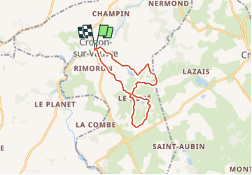
Tocht Stappen van 11,3 km beschikbaar op Centre-Val de Loire, Indre, Crozon-sur-Vauvre. Deze tocht wordt voorgesteld door fanthou.
Beschrijving
Une vallée et un plateau sauvage propices au foisonnement de légendes et de sortilèges à Crozon-sur-Vauvre. Le circuit est à télécharger en cliquant sur "accès au site web".
Plaatsbepaling
Land:
France
Regio :
Centre-Val de Loire
Departement/Provincie :
Indre
Gemeente :
Crozon-sur-Vauvre
Locatie:
Unknown
Vertrek:(Dec)
Vertrek:(UTM)
413284 ; 5149001 (31T) N.
Opmerkingen
Wandeltochten in de omgeving
![Tocht Te voet Saint-Denis-de-Jouhet - Circuit pédestre](https://media.geolcdn.com/t/375/260/ext.jpg?maxdim=2&url=https%3A%2F%2Fstatic1.geolcdn.com%2Fsiteimages%2Fupload%2Ffiles%2F1545311037marcheuse_200dpi.jpg)
![Te voet Te voet](https://static1.geolcdn.com/sitytour/trail-icons/100.png)
Circuit pédestre "moulins et croix"
Te voet
Gemakkelijk
Saint-Denis-de-Jouhet,
Centre-Val de Loire,
Indre,
France
![](/images/other/stat-length.png)
5,5 km | 6,5 km-effort
1h 28min
![](https://static1.geolcdn.com/siteimages/upload/files/16400158638029165_repeat_loop_refresh_sync_direction_icon.png)
Ja
![Tocht Stappen Aigurande - Aigurande Seuvy St Sépulcre - Photo](https://media.geolcdn.com/t/375/260/ext.jpg?maxdim=2&url=https%3A%2F%2Fstatic1.geolcdn.com%2Fsiteimages%2Fupload%2Ffiles%2F1553511878bg_sport_marche.png)
![Stappen Stappen](https://static1.geolcdn.com/sitytour/trail-icons/101.png)
Aigurande Seuvy St Sépulcre
Stappen
Zeer moeilijk
Aigurande,
Centre-Val de Loire,
Indre,
France
![](/images/other/stat-length.png)
19,1 km | 21 km-effort
6h 26min
![](https://static1.geolcdn.com/siteimages/upload/files/16400158638029165_repeat_loop_refresh_sync_direction_icon.png)
Neen
![Tocht Motor Crozon-sur-Vauvre - 2011 12 04 12h38m20 - Photo](https://media.geolcdn.com/t/375/260/ext.jpg?maxdim=2&url=https%3A%2F%2Fstatic1.geolcdn.com%2Fsiteimages%2Fupload%2Ffiles%2F15247431544x4.jpg)
![Motor Motor](https://static1.geolcdn.com/sitytour/trail-icons/400.png)
2011 12 04 12h38m20
Motor
Moeilijk
(1)
Crozon-sur-Vauvre,
Centre-Val de Loire,
Indre,
France
![](/images/other/stat-length.png)
90 km | 111 km-effort
Onbekend
![](https://static1.geolcdn.com/siteimages/upload/files/16400158638029165_repeat_loop_refresh_sync_direction_icon.png)
Ja
![Tocht Motor Crozon-sur-Vauvre - 2011-12-04 12h38m20 - Photo](https://media.geolcdn.com/t/375/260/ext.jpg?maxdim=2&url=https%3A%2F%2Fstatic1.geolcdn.com%2Fsiteimages%2Fupload%2Ffiles%2F15247431544x4.jpg)
![Motor Motor](https://static1.geolcdn.com/sitytour/trail-icons/400.png)
2011-12-04 12h38m20
Motor
Moeilijk
Crozon-sur-Vauvre,
Centre-Val de Loire,
Indre,
France
![](/images/other/stat-length.png)
90 km | 111 km-effort
3h 48min
![](https://static1.geolcdn.com/siteimages/upload/files/16400158638029165_repeat_loop_refresh_sync_direction_icon.png)
Ja