Tocht  Darnieulles - Rando dans les Vosges - Photo

Rando dans les Vosges

 Evenc
Evenc

Gebruiker

© OpenStreetMap contributors
Lengte
Lengte
65 km
Max. hoogte
Max. hoogte
1355 m
Positief hoogteverschil
3098 m
Km-Effort
Km-Effort  
105 km
Min. hoogte
Min. hoogte
321 m
Negatief hoogteverschil
2665 m
Boucle
Boucle
Neen
Datum van aanmaak :
2023-09-21 05:38:35.0
Laatste wijziging :
2023-09-21 14:13:49.674

(0 Bericht)


Scan deze QR-code om de tocht te openen in de SityTrail-applicatie

Gratisgps-wandelapplicatie

Logo SityTrail SityTrail

IGN / Geografische instituten

SityTrail uit de App Store downloaden SityTrail uit Google Play downloaden

Logo SityTrail SityTrail World

De wereld gaat voor u open

SityTrail uit de App Store downloaden SityTrail uit Google Play downloaden SityTrail op Huawei AppGallery downloaden

Over ons

Tocht van 65 km beschikbaar op Grand Est, Vogezen, Darnieulles. Deze tocht wordt voorgesteld door Evenc.

Hoogteprofiel

Plaatsbepaling

Land:
France
Regio :
Grand Est
Departement/Provincie :
Vogezen
Gemeente :
Darnieulles
Locatie:
Unknown
Vertrek:(Dec)
Vertrek:(UTM)
303447 ; 5341343 (32U) N.

Wandeltochten in de omgeving

Tocht Stappen Chaumousey - Bouzey, côté abbaye  - Photo
Stappen
triburemy

Stappen

Medium
Chaumousey, Grand Est, Vogezen, France
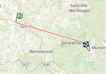
6,1 km | 7,5 km-effort
1h 40min
Ja
Tocht Stappen Sanchey - A la Découverte de BOUZEY - Photo
Stappen
jeanclaude12

Stappen

Heel gemakkelijk
Sanchey, Grand Est, Vogezen, France
7,7 km | 9,3 km-effort
2h 4min
Ja
Tocht Stappen Sanchey - Circuit du tour du Lac de Bouzey - Photo
Stappen
tracegps

Stappen

Gemakkelijk
Sanchey, Grand Est, Vogezen, France
7 km | 8,5 km-effort
1h 40min
Ja
Tocht Mountainbike Chaumousey - Espace VTT FFC Chemins du Coeur des Vosges - circuit n°87 - Circuit de l'Abbaye - Photo
Mountainbike
tracegps

Mountainbike

Medium
(1)
Chaumousey, Grand Est, Vogezen, France
11,7 km | 14,8 km-effort
1h 0min
Ja
Tocht Stappen Chaumousey - bouzey  - Photo
Stappen
randolea

Stappen

Medium
Chaumousey, Grand Est, Vogezen, France
6,3 km | 7,3 km-effort
1h 27min
Ja
Tocht Stappen Les Forges - marche du 23 3 23 - Photo
Stappen
randolea

Stappen

Gemakkelijk
Les Forges, Grand Est, Vogezen, France
4,2 km | 5,2 km-effort
1h 7min
Ja
Tocht Stappen Capavenir-Vosges - Forêt Domevre - Photo
Stappen
triburemy

Stappen

Medium
Capavenir-Vosges, Grand Est, Vogezen, France
7,2 km | 8,2 km-effort
1h 27min
Ja
Tocht Stappen Uxegney - Circuit d''Uxegney - Photo
Stappen
tracegps

Stappen

Moeilijk
(1)
Uxegney, Grand Est, Vogezen, France
12,8 km | 15,1 km-effort
3h 30min
Ja
Tocht Stappen Girancourt - Circuit d''Agémont - Photo
Stappen
tracegps

Stappen

Gemakkelijk
Girancourt, Grand Est, Vogezen, France
7,8 km | 10,2 km-effort
1h 19min
Neen


Sluiten
Mijn abonnementen