![](/images/other/stat-length.png)
![Tocht Stappen Vinadio - Bagni Vinadio J1 à Refuge Mogliorero par P26 - Photo](https://media.geolcdn.com/t/1900/400/ext.pjpeg?maxdim=2&url=https%3A%2F%2Fstatic1.geolcdn.com%2Fsiteimages%2Fupload%2Ffiles%2F1553511878bg_sport_marche.png)
Bagni Vinadio J1 à Refuge Mogliorero par P26
MAD-CVW
Gebruiker
![Lengte](/images/other/stat-length.png)
![Max. hoogte](https://static1.geolcdn.com/siteimages/upload/files/1508320355ic_sort_altitude_max_24dp.png)
![Positief hoogteverschil](https://static1.geolcdn.com/siteimages/upload/files/1508320355ic_sort_den_pos_24dp.png)
![Km-Effort](/images/other/stat-length.png)
![Min. hoogte](https://static1.geolcdn.com/siteimages/upload/files/1508320355ic_sort_altitude_min_24dp.png)
![Negatief hoogteverschil](https://static1.geolcdn.com/siteimages/upload/files/1508320355ic_sort_den_neg_24dp.png)
![Boucle](https://static1.geolcdn.com/siteimages/upload/files/16400158638029165_repeat_loop_refresh_sync_direction_icon.png)
![Stappen](https://static1.geolcdn.com/sitytour/trail-icons/101.png)
5h11
Moeilijkheid : Zeer moeilijk
![Scan deze QR-code om de tocht te openen in de SityTrail-applicatie](https://capi.geolives.com/qq0zvz2zws4bq2lad0pu/sitytour/trails/3795159/qr.png?size=200)
Gratisgps-wandelapplicatie
Over ons
Tocht Stappen van 14,5 km beschikbaar op Piëmont, Cuneo, Vinadio. Deze tocht wordt voorgesteld door MAD-CVW.
Beschrijving
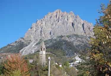
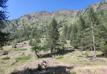
départ de Bagni en montant l'itinéraire P26 balisé rouge-blanc, a droite de l'église sur beau sentier prenant rapidement de l'altitude. passage dans le village de Besmorello aux maisons typiques, puis le sentier progresse par des prairies jusqu'au hameau de Luca a 1542m. Sculptures en tôle de Loulou.
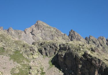
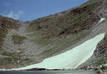
Prendre le chemin à gauche pour monter par la rive droite du torrent Ischiator et rejoindre le sentier vers le refuge en laissant le chemin carrossable sur la droite. Traverser un pont, le sentier monte rive gauche jusqu'à une très belle cascade a 1800m, puis monté agréable jusqu'au bas du refuge
Retour par même chemin avec variante par Strada rive gauche jusqu'à Besmorello, puis sentier descendant à Bagni.
Plaatsbepaling
Opmerkingen
Wandeltochten in de omgeving
![Tocht Te voet Vinadio - Alte Valli - Tappa 02 - Photo](https://media.geolcdn.com/t/375/260/c740d10d-1035-4c17-b746-4abae2faca8a.jpeg&format=jpg&maxdim=2)
![Te voet Te voet](https://static1.geolcdn.com/sitytour/trail-icons/100.png)
Te voet
![](/images/other/stat-length.png)
![](https://static1.geolcdn.com/siteimages/upload/files/16400158638029165_repeat_loop_refresh_sync_direction_icon.png)
![Tocht Te voet Vinadio - (SI E14) Vinadio Frazione Strepeis - Sambuco - Photo](https://media.geolcdn.com/t/375/260/ac5e8239-e7ed-43bc-86ad-324f2c2e7376.jpeg&format=jpg&maxdim=2)
![Te voet Te voet](https://static1.geolcdn.com/sitytour/trail-icons/100.png)
Te voet
![](/images/other/stat-length.png)
![](https://static1.geolcdn.com/siteimages/upload/files/16400158638029165_repeat_loop_refresh_sync_direction_icon.png)
![Tocht Te voet Vinadio - San Bernolfo-Corborant - Photo](https://media.geolcdn.com/t/375/260/d482fac5-441b-457e-9b24-5a828305619b.jpeg&format=jpg&maxdim=2)
![Te voet Te voet](https://static1.geolcdn.com/sitytour/trail-icons/100.png)
Te voet
![](/images/other/stat-length.png)
![](https://static1.geolcdn.com/siteimages/upload/files/16400158638029165_repeat_loop_refresh_sync_direction_icon.png)
![Tocht Stappen Vinadio - Étape 4 Refuge Alexandris Foche / Isola 2000 - Photo](https://media.geolcdn.com/t/375/260/859c6382-0d81-454d-80a8-0fe96066cf42.jpg&format=jpg&maxdim=2)
![Stappen Stappen](https://static1.geolcdn.com/sitytour/trail-icons/101.png)
Stappen
![](/images/other/stat-length.png)
![](https://static1.geolcdn.com/siteimages/upload/files/16400158638029165_repeat_loop_refresh_sync_direction_icon.png)
![Tocht Te voet Vinadio - IT-P49 - Photo](https://media.geolcdn.com/t/375/260/2964e30b-263b-42c3-aa1c-ecaafebd0df1.jpeg&format=jpg&maxdim=2)
![Te voet Te voet](https://static1.geolcdn.com/sitytour/trail-icons/100.png)
![Tocht Te voet Pietraporzio - IT-P48 - Photo](https://media.geolcdn.com/t/375/260/c740d10d-1035-4c17-b746-4abae2faca8a.jpeg&format=jpg&maxdim=2)
![Te voet Te voet](https://static1.geolcdn.com/sitytour/trail-icons/100.png)
Te voet
![](/images/other/stat-length.png)
![](https://static1.geolcdn.com/siteimages/upload/files/16400158638029165_repeat_loop_refresh_sync_direction_icon.png)
![Tocht Te voet Vinadio - Alte Valli - Tappa 01 - Photo](https://media.geolcdn.com/t/375/260/2964e30b-263b-42c3-aa1c-ecaafebd0df1.jpeg&format=jpg&maxdim=2)
![Te voet Te voet](https://static1.geolcdn.com/sitytour/trail-icons/100.png)
Te voet
![](/images/other/stat-length.png)
![](https://static1.geolcdn.com/siteimages/upload/files/16400158638029165_repeat_loop_refresh_sync_direction_icon.png)
![Tocht Te voet Vinadio - San Bernolfo-Testa dell'Autaret - Photo](https://media.geolcdn.com/t/375/260/2a1b2926-4bfb-46fc-a4ad-6cffdfc90984.jpeg&format=jpg&maxdim=2)
![Te voet Te voet](https://static1.geolcdn.com/sitytour/trail-icons/100.png)
Te voet
![](/images/other/stat-length.png)
![](https://static1.geolcdn.com/siteimages/upload/files/16400158638029165_repeat_loop_refresh_sync_direction_icon.png)
![Tocht Stappen Vinadio - J3-Vallon Tesina - Passo Sometta - Vallon Sauma - Photo](https://media.geolcdn.com/t/375/260/ext.jpg?maxdim=2&url=https%3A%2F%2Fstatic1.geolcdn.com%2Fsiteimages%2Fupload%2Ffiles%2F1553511878bg_sport_marche.png)
![Stappen Stappen](https://static1.geolcdn.com/sitytour/trail-icons/101.png)
Stappen
![](/images/other/stat-length.png)
![](https://static1.geolcdn.com/siteimages/upload/files/16400158638029165_repeat_loop_refresh_sync_direction_icon.png)