![](/images/other/stat-length.png)
![Tocht Stappen Niederbronn-les-Bains - Déviation Rectangle Rouge / GR53 par croix rouge puis chevalet bleu - Photo](https://media.geolcdn.com/t/1900/400/ext.pjpeg?maxdim=2&url=https%3A%2F%2Fstatic1.geolcdn.com%2Fsiteimages%2Fupload%2Ffiles%2F1553511878bg_sport_marche.png)
Déviation Rectangle Rouge / GR53 par croix rouge puis chevalet bleu
Dominique Baudelocque
Gebruiker
![Lengte](/images/other/stat-length.png)
![Max. hoogte](https://static1.geolcdn.com/siteimages/upload/files/1508320355ic_sort_altitude_max_24dp.png)
![Positief hoogteverschil](https://static1.geolcdn.com/siteimages/upload/files/1508320355ic_sort_den_pos_24dp.png)
![Km-Effort](/images/other/stat-length.png)
![Min. hoogte](https://static1.geolcdn.com/siteimages/upload/files/1508320355ic_sort_altitude_min_24dp.png)
![Negatief hoogteverschil](https://static1.geolcdn.com/siteimages/upload/files/1508320355ic_sort_den_neg_24dp.png)
![Boucle](https://static1.geolcdn.com/siteimages/upload/files/16400158638029165_repeat_loop_refresh_sync_direction_icon.png)
![Stappen](https://static1.geolcdn.com/sitytour/trail-icons/101.png)
2h19
Moeilijkheid : Medium
![Scan deze QR-code om de tocht te openen in de SityTrail-applicatie](https://capi.geolives.com/qq0zvz2zws4bq2lad0pu/sitytour/trails/3795149/qr.png?size=200)
Gratisgps-wandelapplicatie
Over ons
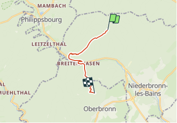
Tocht Stappen van 6,4 km beschikbaar op Grand Est, Bas-Rhin, Niederbronn-les-Bains. Deze tocht wordt voorgesteld door Dominique Baudelocque .
Beschrijving
Travaux du 08/09 au 31/12/2023 au niveau de l'usine Celtic (rond-point D1062 - Source Lichteneck)
Déviation Niederbronn possible entre le Grand Wintersberg et Kreuztannen par croix rouge puis chevalet bleu en traversant Breitenwasen (et la D1062 prudemment)
Rectangle rouge et triangle rouge en impasse au niveau de l'usine Celtic: ne pas descendre sous le Camp Celtique ou l'anneau bleu du Grand Wintersberg
Plaatsbepaling
Opmerkingen
Wandeltochten in de omgeving
![Tocht Stappen Oberbronn - En forêt de Niederbronn de Oberbronn au château de Wasenbourg - Photo](https://media.geolcdn.com/t/375/260/ext.jpg?maxdim=2&url=https%3A%2F%2Fservices.sitytrail.com%2FGeolivesWS%2FDownloadMedia.ashx%3FTrailID%3D317705%26Media%3D17009_6.jpg)
![Stappen Stappen](https://static1.geolcdn.com/sitytour/trail-icons/101.png)
Stappen
![](/images/other/stat-length.png)
![](https://static1.geolcdn.com/siteimages/upload/files/16400158638029165_repeat_loop_refresh_sync_direction_icon.png)
![Tocht Te voet Niederbronn-les-Bains - Disque rouge - Photo](https://media.geolcdn.com/t/375/260/d554d1d5-941b-4379-be0a-3d5a4aad456e.jpeg&format=jpg&maxdim=2)
![Te voet Te voet](https://static1.geolcdn.com/sitytour/trail-icons/100.png)
Te voet
![](/images/other/stat-length.png)
![](https://static1.geolcdn.com/siteimages/upload/files/16400158638029165_repeat_loop_refresh_sync_direction_icon.png)
![Tocht Te voet Philippsbourg - Yellow X - Photo](https://media.geolcdn.com/t/375/260/405334b8-fc9f-4697-8248-e0a1e7aa1239.jpeg&format=jpg&maxdim=2)
![Te voet Te voet](https://static1.geolcdn.com/sitytour/trail-icons/100.png)
Te voet
![](/images/other/stat-length.png)
![](https://static1.geolcdn.com/siteimages/upload/files/16400158638029165_repeat_loop_refresh_sync_direction_icon.png)
![Tocht Te voet Philippsbourg - Red dot - Photo](https://media.geolcdn.com/t/375/260/41711dff-01c3-4002-aacf-819b06d7da02.jpeg&format=jpg&maxdim=2)
![Te voet Te voet](https://static1.geolcdn.com/sitytour/trail-icons/100.png)
Te voet
![](/images/other/stat-length.png)
![](https://static1.geolcdn.com/siteimages/upload/files/16400158638029165_repeat_loop_refresh_sync_direction_icon.png)
![Tocht Te voet Philippsbourg - Red triangle - Photo](https://media.geolcdn.com/t/375/260/41711dff-01c3-4002-aacf-819b06d7da02.jpeg&format=jpg&maxdim=2)
![Te voet Te voet](https://static1.geolcdn.com/sitytour/trail-icons/100.png)
Te voet
![](/images/other/stat-length.png)
![](https://static1.geolcdn.com/siteimages/upload/files/16400158638029165_repeat_loop_refresh_sync_direction_icon.png)
![Tocht Te voet Philippsbourg - Sentier Goldenberg - Photo](https://media.geolcdn.com/t/375/260/6348f4f6-901a-4514-89c9-fdb6087d121c.jpeg&format=jpg&maxdim=2)
![Te voet Te voet](https://static1.geolcdn.com/sitytour/trail-icons/100.png)
Te voet
![](/images/other/stat-length.png)
![](https://static1.geolcdn.com/siteimages/upload/files/16400158638029165_repeat_loop_refresh_sync_direction_icon.png)
![Tocht Te voet Philippsbourg - Yellow cross - Photo](https://media.geolcdn.com/t/375/260/fff2d3ea-92b0-447d-8719-9088e8932805.jpeg&format=jpg&maxdim=2)
![Te voet Te voet](https://static1.geolcdn.com/sitytour/trail-icons/100.png)
Te voet
![](/images/other/stat-length.png)
![](https://static1.geolcdn.com/siteimages/upload/files/16400158638029165_repeat_loop_refresh_sync_direction_icon.png)
![Tocht Te voet Philippsbourg - Yellow triangle - Photo](https://media.geolcdn.com/t/375/260/06ca872b-8d67-47d3-9a5d-7e9e4cc69f4c.jpeg&format=jpg&maxdim=2)
![Te voet Te voet](https://static1.geolcdn.com/sitytour/trail-icons/100.png)
Te voet
![](/images/other/stat-length.png)
![](https://static1.geolcdn.com/siteimages/upload/files/16400158638029165_repeat_loop_refresh_sync_direction_icon.png)
![Tocht Te voet Baerenthal - Yellow-white-yellow rectangle - Photo](https://media.geolcdn.com/t/375/260/5ae83fc0-06cf-4be7-8fed-38c858299126.jpeg&format=jpg&maxdim=2)
![Te voet Te voet](https://static1.geolcdn.com/sitytour/trail-icons/100.png)
Te voet
![](/images/other/stat-length.png)
![](https://static1.geolcdn.com/siteimages/upload/files/16400158638029165_repeat_loop_refresh_sync_direction_icon.png)