![](/images/other/stat-length.png)
![Tocht Te voet Niederbronn-les-Bains - Déviation RECTANGLE ROUGE / GR53 / Triangle rouge par anneau bleu puis croix bleue du 8/09 au 31/12/2023 - Photo](https://media.geolcdn.com/t/1900/400/ext.pjpeg?maxdim=2&url=https%3A%2F%2Fstatic1.geolcdn.com%2Fsiteimages%2Fupload%2Ffiles%2F1545311037marcheuse_200dpi.jpg)
Déviation RECTANGLE ROUGE / GR53 / Triangle rouge par anneau bleu puis croix bleue du 8/09 au 31/12/2023
Dominique Baudelocque
Gebruiker
![Lengte](/images/other/stat-length.png)
![Max. hoogte](https://static1.geolcdn.com/siteimages/upload/files/1508320355ic_sort_altitude_max_24dp.png)
![Positief hoogteverschil](https://static1.geolcdn.com/siteimages/upload/files/1508320355ic_sort_den_pos_24dp.png)
![Km-Effort](/images/other/stat-length.png)
![Min. hoogte](https://static1.geolcdn.com/siteimages/upload/files/1508320355ic_sort_altitude_min_24dp.png)
![Negatief hoogteverschil](https://static1.geolcdn.com/siteimages/upload/files/1508320355ic_sort_den_neg_24dp.png)
![Boucle](https://static1.geolcdn.com/siteimages/upload/files/16400158638029165_repeat_loop_refresh_sync_direction_icon.png)
![Te voet](https://static1.geolcdn.com/sitytour/trail-icons/100.png)
2h46
Moeilijkheid : Gemakkelijk
![Scan deze QR-code om de tocht te openen in de SityTrail-applicatie](https://capi.geolives.com/qq0zvz2zws4bq2lad0pu/sitytour/trails/3795101/qr.png?size=200)
Gratisgps-wandelapplicatie
Over ons
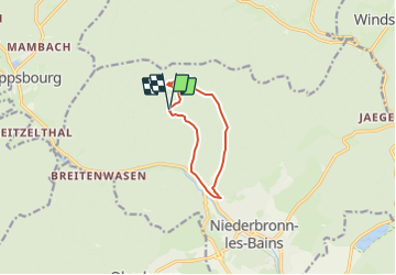
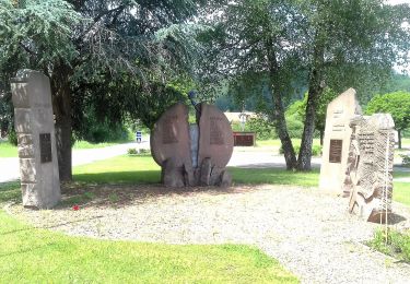
Tocht Te voet van 7,8 km beschikbaar op Grand Est, Bas-Rhin, Niederbronn-les-Bains. Deze tocht wordt voorgesteld door Dominique Baudelocque .
Beschrijving
Travaux rond point Celtic // D1062 - Niederbronn
4.87 km = déviation
Direct source Lichteneck par Rectangle Rouge / G53 = 2.877 = impasse en bas au niveau usine Celtic
Soit 2 km de plus
Attention conditions hivernale = glissant sur le 1er tiers de la croix bleue entre col de la Liese et Acacias (Niederbronn)
Plaatsbepaling
Opmerkingen
Wandeltochten in de omgeving
![Tocht Stappen Oberbronn - En forêt de Niederbronn de Oberbronn au château de Wasenbourg - Photo](https://media.geolcdn.com/t/375/260/ext.jpg?maxdim=2&url=https%3A%2F%2Fservices.sitytrail.com%2FGeolivesWS%2FDownloadMedia.ashx%3FTrailID%3D317705%26Media%3D17009_6.jpg)
![Stappen Stappen](https://static1.geolcdn.com/sitytour/trail-icons/101.png)
Stappen
![](/images/other/stat-length.png)
![](https://static1.geolcdn.com/siteimages/upload/files/16400158638029165_repeat_loop_refresh_sync_direction_icon.png)
![Tocht Te voet Niederbronn-les-Bains - Disque rouge - Photo](https://media.geolcdn.com/t/375/260/d554d1d5-941b-4379-be0a-3d5a4aad456e.jpeg&format=jpg&maxdim=2)
![Te voet Te voet](https://static1.geolcdn.com/sitytour/trail-icons/100.png)
Te voet
![](/images/other/stat-length.png)
![](https://static1.geolcdn.com/siteimages/upload/files/16400158638029165_repeat_loop_refresh_sync_direction_icon.png)
![Tocht Te voet Philippsbourg - Yellow X - Photo](https://media.geolcdn.com/t/375/260/405334b8-fc9f-4697-8248-e0a1e7aa1239.jpeg&format=jpg&maxdim=2)
![Te voet Te voet](https://static1.geolcdn.com/sitytour/trail-icons/100.png)
Te voet
![](/images/other/stat-length.png)
![](https://static1.geolcdn.com/siteimages/upload/files/16400158638029165_repeat_loop_refresh_sync_direction_icon.png)
![Tocht Te voet Philippsbourg - Red dot - Photo](https://media.geolcdn.com/t/375/260/41711dff-01c3-4002-aacf-819b06d7da02.jpeg&format=jpg&maxdim=2)
![Te voet Te voet](https://static1.geolcdn.com/sitytour/trail-icons/100.png)
Te voet
![](/images/other/stat-length.png)
![](https://static1.geolcdn.com/siteimages/upload/files/16400158638029165_repeat_loop_refresh_sync_direction_icon.png)
![Tocht Te voet Philippsbourg - Red triangle - Photo](https://media.geolcdn.com/t/375/260/41711dff-01c3-4002-aacf-819b06d7da02.jpeg&format=jpg&maxdim=2)
![Te voet Te voet](https://static1.geolcdn.com/sitytour/trail-icons/100.png)
Te voet
![](/images/other/stat-length.png)
![](https://static1.geolcdn.com/siteimages/upload/files/16400158638029165_repeat_loop_refresh_sync_direction_icon.png)
![Tocht Te voet Philippsbourg - Sentier Goldenberg - Photo](https://media.geolcdn.com/t/375/260/6348f4f6-901a-4514-89c9-fdb6087d121c.jpeg&format=jpg&maxdim=2)
![Te voet Te voet](https://static1.geolcdn.com/sitytour/trail-icons/100.png)
Te voet
![](/images/other/stat-length.png)
![](https://static1.geolcdn.com/siteimages/upload/files/16400158638029165_repeat_loop_refresh_sync_direction_icon.png)
![Tocht Te voet Philippsbourg - Yellow cross - Photo](https://media.geolcdn.com/t/375/260/fff2d3ea-92b0-447d-8719-9088e8932805.jpeg&format=jpg&maxdim=2)
![Te voet Te voet](https://static1.geolcdn.com/sitytour/trail-icons/100.png)
Te voet
![](/images/other/stat-length.png)
![](https://static1.geolcdn.com/siteimages/upload/files/16400158638029165_repeat_loop_refresh_sync_direction_icon.png)
![Tocht Te voet Philippsbourg - Yellow triangle - Photo](https://media.geolcdn.com/t/375/260/06ca872b-8d67-47d3-9a5d-7e9e4cc69f4c.jpeg&format=jpg&maxdim=2)
![Te voet Te voet](https://static1.geolcdn.com/sitytour/trail-icons/100.png)
Te voet
![](/images/other/stat-length.png)
![](https://static1.geolcdn.com/siteimages/upload/files/16400158638029165_repeat_loop_refresh_sync_direction_icon.png)
![Tocht Te voet Baerenthal - Yellow-white-yellow rectangle - Photo](https://media.geolcdn.com/t/375/260/5ae83fc0-06cf-4be7-8fed-38c858299126.jpeg&format=jpg&maxdim=2)
![Te voet Te voet](https://static1.geolcdn.com/sitytour/trail-icons/100.png)
Te voet
![](/images/other/stat-length.png)
![](https://static1.geolcdn.com/siteimages/upload/files/16400158638029165_repeat_loop_refresh_sync_direction_icon.png)