![](/images/other/stat-length.png)
![Tocht Stappen Aulus-les-Bains - SityTrail - Etang du Garbet - septembre 2023 - Photo](https://media.geolcdn.com/t/1900/400/ext.pjpeg?maxdim=2&url=https%3A%2F%2Fstatic1.geolcdn.com%2Fsiteimages%2Fupload%2Ffiles%2F1553511878bg_sport_marche.png)
SityTrail - Etang du Garbet - septembre 2023
lebarça
Gebruiker
![Lengte](/images/other/stat-length.png)
Lengte
7,7 km
![Max. hoogte](https://static1.geolcdn.com/siteimages/upload/files/1508320355ic_sort_altitude_max_24dp.png)
Max. hoogte
1692 m
![Positief hoogteverschil](https://static1.geolcdn.com/siteimages/upload/files/1508320355ic_sort_den_pos_24dp.png)
Positief hoogteverschil
572 m
![Km-Effort](/images/other/stat-length.png)
Km-Effort
15,3 km
![Min. hoogte](https://static1.geolcdn.com/siteimages/upload/files/1508320355ic_sort_altitude_min_24dp.png)
Min. hoogte
1133 m
![Negatief hoogteverschil](https://static1.geolcdn.com/siteimages/upload/files/1508320355ic_sort_den_neg_24dp.png)
Negatief hoogteverschil
564 m
![Boucle](https://static1.geolcdn.com/siteimages/upload/files/16400158638029165_repeat_loop_refresh_sync_direction_icon.png)
Boucle
Ja
Datum van aanmaak :
2023-09-03 15:46:49.661
Laatste wijziging :
2023-09-03 16:10:39.697
![Stappen](https://static1.geolcdn.com/sitytour/trail-icons/101.png)
3h28
Moeilijkheid : Moeilijk
![Scan deze QR-code om de tocht te openen in de SityTrail-applicatie](https://capi.geolives.com/qq0zvz2zws4bq2lad0pu/sitytour/trails/3794086/qr.png?size=200)
Gratisgps-wandelapplicatie
Over ons
Tocht Stappen van 7,7 km beschikbaar op Occitanië, Ariège, Aulus-les-Bains. Deze tocht wordt voorgesteld door lebarça.
Beschrijving
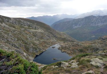
préservez l'intimité des bergers (ici, un couple) : n'approcher pas de leur abri-pastoral au fond du lac à gauche : cabane en bois légère et temporaire pour passer plusieurs nuits auprès de leurs brebis
Plaatsbepaling
Land:
France
Regio :
Occitanië
Departement/Provincie :
Ariège
Gemeente :
Aulus-les-Bains
Locatie:
Unknown
Vertrek:(Dec)
Vertrek:(UTM)
367531 ; 4737035 (31T) N.
Opmerkingen
Wandeltochten in de omgeving
![Tocht Stappen Aulus-les-Bains - cascade ars et etang guzet - Photo](https://media.geolcdn.com/t/375/260/ext.jpg?maxdim=2&url=https%3A%2F%2Fservices.sitytrail.com%2FGeolivesWS%2FDownloadMedia.ashx%3FTrailID%3D142908%26Media%3D20120731151659.jpeg)
![Stappen Stappen](https://static1.geolcdn.com/sitytour/trail-icons/101.png)
cascade ars et etang guzet
Stappen
Moeilijk
(1)
Aulus-les-Bains,
Occitanië,
Ariège,
France
![](/images/other/stat-length.png)
15,3 km | 28 km-effort
4h 58min
![](https://static1.geolcdn.com/siteimages/upload/files/16400158638029165_repeat_loop_refresh_sync_direction_icon.png)
Ja
![Tocht Stappen Le Port - Pic des Trois Seigneurs - Photo](https://media.geolcdn.com/t/375/260/ext.jpg?maxdim=2&url=https%3A%2F%2Fservices.sitytrail.com%2FGeolivesWS%2FDownloadMedia.ashx%3FTrailID%3D104491%26Media%3D7812_3.jpg)
![Stappen Stappen](https://static1.geolcdn.com/sitytour/trail-icons/101.png)
Pic des Trois Seigneurs
Stappen
Medium
(2)
Le Port,
Occitanië,
Ariège,
France
![](/images/other/stat-length.png)
9,2 km | 19,5 km-effort
6h 0min
![](https://static1.geolcdn.com/siteimages/upload/files/16400158638029165_repeat_loop_refresh_sync_direction_icon.png)
Neen
![Tocht Stappen Aulus-les-Bains - Cascade d'Ars - Étang de Guzet - Photo](https://media.geolcdn.com/t/375/260/ext.jpg?maxdim=2&url=https%3A%2F%2Fstatic1.geolcdn.com%2Fsiteimages%2Fupload%2Ffiles%2F1553511878bg_sport_marche.png)
![Stappen Stappen](https://static1.geolcdn.com/sitytour/trail-icons/101.png)
Cascade d'Ars - Étang de Guzet
Stappen
Medium
(1)
Aulus-les-Bains,
Occitanië,
Ariège,
France
![](/images/other/stat-length.png)
15 km | 27 km-effort
6h 12min
![](https://static1.geolcdn.com/siteimages/upload/files/16400158638029165_repeat_loop_refresh_sync_direction_icon.png)
Ja
![Tocht Stappen Aulus-les-Bains - Le plateau de Souliou - Photo](https://media.geolcdn.com/t/375/260/ext.jpg?maxdim=2&url=https%3A%2F%2Fservices.sitytrail.com%2FGeolivesWS%2FDownloadMedia.ashx%3FTrailID%3D109234%26Media%3D3311_1.jpg)
![Stappen Stappen](https://static1.geolcdn.com/sitytour/trail-icons/101.png)
Le plateau de Souliou
Stappen
Moeilijk
(1)
Aulus-les-Bains,
Occitanië,
Ariège,
France
![](/images/other/stat-length.png)
6,3 km | 13,4 km-effort
2h 45min
![](https://static1.geolcdn.com/siteimages/upload/files/16400158638029165_repeat_loop_refresh_sync_direction_icon.png)
Ja
![Tocht Stappen Aulus-les-Bains - Le Mont Ceint ou Pic de Girantes - Photo](https://media.geolcdn.com/t/375/260/ext.jpg?maxdim=2&url=https%3A%2F%2Fservices.sitytrail.com%2FGeolivesWS%2FDownloadMedia.ashx%3FTrailID%3D109148%26Media%3D3190_1.jpg)
![Stappen Stappen](https://static1.geolcdn.com/sitytour/trail-icons/101.png)
Le Mont Ceint ou Pic de Girantes
Stappen
Moeilijk
(2)
Aulus-les-Bains,
Occitanië,
Ariège,
France
![](/images/other/stat-length.png)
8,2 km | 16,9 km-effort
4h 30min
![](https://static1.geolcdn.com/siteimages/upload/files/16400158638029165_repeat_loop_refresh_sync_direction_icon.png)
Ja
![Tocht Stappen Aulus-les-Bains - Pic rouge de Bassiès - Photo](https://media.geolcdn.com/t/375/260/ext.jpg?maxdim=2&url=https%3A%2F%2Fservices.sitytrail.com%2FGeolivesWS%2FDownloadMedia.ashx%3FTrailID%3D109133%26Media%3D3173_1.jpg)
![Stappen Stappen](https://static1.geolcdn.com/sitytour/trail-icons/101.png)
Pic rouge de Bassiès
Stappen
Moeilijk
(1)
Aulus-les-Bains,
Occitanië,
Ariège,
France
![](/images/other/stat-length.png)
17,4 km | 36 km-effort
8h 0min
![](https://static1.geolcdn.com/siteimages/upload/files/16400158638029165_repeat_loop_refresh_sync_direction_icon.png)
Ja
![Tocht Stappen Auzat - GR10-8 - Photo](https://media.geolcdn.com/t/375/260/ext.jpg?maxdim=2&url=https%3A%2F%2Fstatic1.geolcdn.com%2Fsiteimages%2Fupload%2Ffiles%2F1553511878bg_sport_marche.png)
![Stappen Stappen](https://static1.geolcdn.com/sitytour/trail-icons/101.png)
![Tocht Stappen Aulus-les-Bains - G4 chemin des mines fait - Photo](https://media.geolcdn.com/t/375/260/ext.jpg?maxdim=2&url=https%3A%2F%2Fstatic1.geolcdn.com%2Fsiteimages%2Fupload%2Ffiles%2F1553511878bg_sport_marche.png)
![Stappen Stappen](https://static1.geolcdn.com/sitytour/trail-icons/101.png)
G4 chemin des mines fait
Stappen
Moeilijk
(1)
Aulus-les-Bains,
Occitanië,
Ariège,
France
![](/images/other/stat-length.png)
7,6 km | 13,5 km-effort
5h 25min
![](https://static1.geolcdn.com/siteimages/upload/files/16400158638029165_repeat_loop_refresh_sync_direction_icon.png)
Ja
![Tocht Stappen Aulus-les-Bains - Le tours des cascades - Photo](https://media.geolcdn.com/t/375/260/ext.jpg?maxdim=2&url=https%3A%2F%2Fstatic1.geolcdn.com%2Fsiteimages%2Fupload%2Ffiles%2F1553511878bg_sport_marche.png)
![Stappen Stappen](https://static1.geolcdn.com/sitytour/trail-icons/101.png)
Le tours des cascades
Stappen
Medium
(1)
Aulus-les-Bains,
Occitanië,
Ariège,
France
![](/images/other/stat-length.png)
11,7 km | 23 km-effort
4h 51min
![](https://static1.geolcdn.com/siteimages/upload/files/16400158638029165_repeat_loop_refresh_sync_direction_icon.png)
Ja