![](/images/other/stat-length.png)
![Tocht Stappen Bagni di Lucca - Boucle au départ de Casoli - Photo](https://media.geolcdn.com/t/1900/400/fc59d97a-d270-45eb-9a0d-161c90ce5c50.jpg&format=pjpeg&maxdim=2)
Boucle au départ de Casoli
Elis Barbieri - Crb
Gebruiker
![Lengte](/images/other/stat-length.png)
![Max. hoogte](https://static1.geolcdn.com/siteimages/upload/files/1508320355ic_sort_altitude_max_24dp.png)
![Positief hoogteverschil](https://static1.geolcdn.com/siteimages/upload/files/1508320355ic_sort_den_pos_24dp.png)
![Km-Effort](/images/other/stat-length.png)
![Min. hoogte](https://static1.geolcdn.com/siteimages/upload/files/1508320355ic_sort_altitude_min_24dp.png)
![Negatief hoogteverschil](https://static1.geolcdn.com/siteimages/upload/files/1508320355ic_sort_den_neg_24dp.png)
![Boucle](https://static1.geolcdn.com/siteimages/upload/files/16400158638029165_repeat_loop_refresh_sync_direction_icon.png)
![Stappen](https://static1.geolcdn.com/sitytour/trail-icons/101.png)
5h51
Moeilijkheid : Medium
![Scan deze QR-code om de tocht te openen in de SityTrail-applicatie](https://capi.geolives.com/qq0zvz2zws4bq2lad0pu/sitytour/trails/3790548/qr.png?size=200)
Gratisgps-wandelapplicatie
Over ons
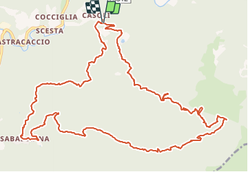
Tocht Stappen van 17,2 km beschikbaar op Toscane, Lucca, Bagni di Lucca. Deze tocht wordt voorgesteld door Elis Barbieri - Crb.
Beschrijving
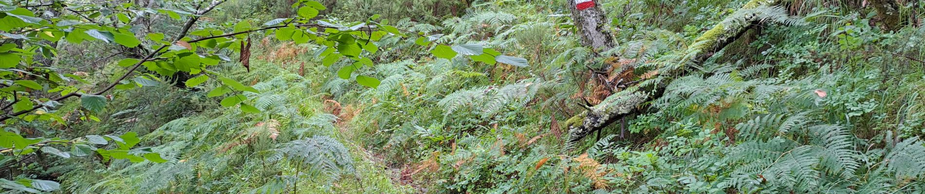
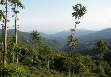
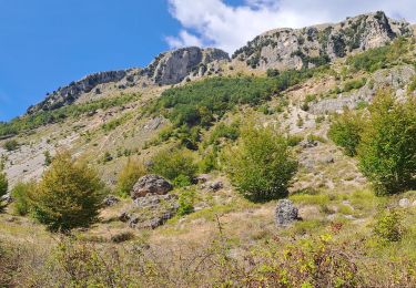
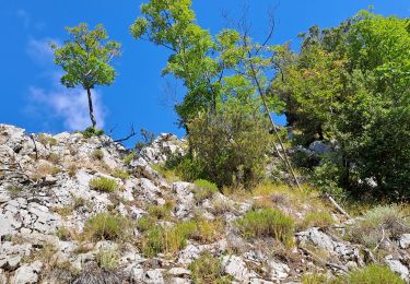
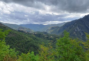
Rando en boucle au départ du joli village de Casoli. La montée se fait dans des sentiers très escarpés et souvent cachés par la végétation mais le marquage "rouge-blanc" type GR est parfait. La partie la plus sportive se situe du km 3,3 au km 6. Ensuite le plateau et la descente se font sur de larges sentiers forestiers sans difficultés. La boucle se fait entièrement en châtaigneraie ombragée.
Plaatsbepaling
Opmerkingen
Wandeltochten in de omgeving
![Tocht Te voet Pescia - IT-52 - Photo](https://media.geolcdn.com/t/375/260/b871676c-6025-48ad-ad3b-b82c7f7327ac.jpeg&format=jpg&maxdim=2)
![Te voet Te voet](https://static1.geolcdn.com/sitytour/trail-icons/100.png)
![Tocht Te voet Bagni di Lucca - IT-54 - Photo](https://media.geolcdn.com/t/375/260/23cf56b3-e325-4156-a8f1-277db57b2059.jpeg&format=jpg&maxdim=2)
![Te voet Te voet](https://static1.geolcdn.com/sitytour/trail-icons/100.png)
Te voet
![](/images/other/stat-length.png)
![](https://static1.geolcdn.com/siteimages/upload/files/16400158638029165_repeat_loop_refresh_sync_direction_icon.png)
![Tocht Stappen Bagni di Lucca - Boucle San Cassiano - Prato Fiorito - Photo](https://media.geolcdn.com/t/375/260/6a9f9808-3708-4647-be46-be508d128fb5.jpg&format=jpg&maxdim=2)
![Stappen Stappen](https://static1.geolcdn.com/sitytour/trail-icons/101.png)
Stappen
![](/images/other/stat-length.png)
![](https://static1.geolcdn.com/siteimages/upload/files/16400158638029165_repeat_loop_refresh_sync_direction_icon.png)
![Tocht Stappen Bagni di Lucca - Aller-retour Vico Pancellorum - Schiena d'Asino - Photo](https://media.geolcdn.com/t/375/260/8af9b01f-c4e3-4c55-8be7-e363bf0cd6fc.jpg&format=jpg&maxdim=2)
![Stappen Stappen](https://static1.geolcdn.com/sitytour/trail-icons/101.png)
Stappen
![](/images/other/stat-length.png)
![](https://static1.geolcdn.com/siteimages/upload/files/16400158638029165_repeat_loop_refresh_sync_direction_icon.png)
![Tocht Stappen Bagni di Lucca - Limano - Madonna Di Limano - Photo](https://media.geolcdn.com/t/375/260/6adbac03-f63f-4574-b387-dd2a387b8a09.jpg&format=jpg&maxdim=2)
![Stappen Stappen](https://static1.geolcdn.com/sitytour/trail-icons/101.png)
Stappen
![](/images/other/stat-length.png)
![](https://static1.geolcdn.com/siteimages/upload/files/16400158638029165_repeat_loop_refresh_sync_direction_icon.png)
![Tocht Stappen Bagni di Lucca - Lucchio (Bagni di Lucca) - Photo](https://media.geolcdn.com/t/375/260/811a5c4f-95ab-4546-9bf0-284b53193d5d.jpg&format=jpg&maxdim=2)
![Stappen Stappen](https://static1.geolcdn.com/sitytour/trail-icons/101.png)
Stappen
![](/images/other/stat-length.png)
![](https://static1.geolcdn.com/siteimages/upload/files/16400158638029165_repeat_loop_refresh_sync_direction_icon.png)
![Tocht Te voet Bagni di Lucca - IT-8 - Photo](https://media.geolcdn.com/t/375/260/7b8abb41-a964-4077-bb94-1fdcad2a45d9.jpeg&format=jpg&maxdim=2)
![Te voet Te voet](https://static1.geolcdn.com/sitytour/trail-icons/100.png)
![Tocht Te voet Bagni di Lucca - IT-10 - Photo](https://media.geolcdn.com/t/375/260/ext.jpg?maxdim=2&url=https%3A%2F%2Fstatic1.geolcdn.com%2Fsiteimages%2Fupload%2Ffiles%2F1545311037marcheuse_200dpi.jpg)
![Te voet Te voet](https://static1.geolcdn.com/sitytour/trail-icons/100.png)
Te voet
![](/images/other/stat-length.png)
![](https://static1.geolcdn.com/siteimages/upload/files/16400158638029165_repeat_loop_refresh_sync_direction_icon.png)
![Tocht Te voet Bagni di Lucca - IT-12 - Photo](https://media.geolcdn.com/t/375/260/ext.jpg?maxdim=2&url=https%3A%2F%2Fstatic1.geolcdn.com%2Fsiteimages%2Fupload%2Ffiles%2F1545311037marcheuse_200dpi.jpg)
![Te voet Te voet](https://static1.geolcdn.com/sitytour/trail-icons/100.png)
Te voet
![](/images/other/stat-length.png)
![](https://static1.geolcdn.com/siteimages/upload/files/16400158638029165_repeat_loop_refresh_sync_direction_icon.png)