


25 km | 32 km-effort
Randonnées de la Grande Forêt de Saint-Hubert GUIDE+


Gratisgps-wandelapplicatie
 SityTrail
IGN / Geografische instituten
SityTrail World
De wereld gaat voor u open
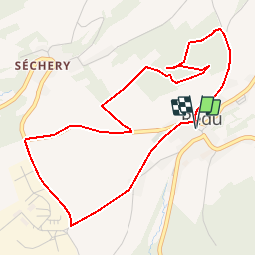
Tocht Stappen van 4,8 km beschikbaar op Wallonië, Luxemburg, Libin. Deze tocht wordt voorgesteld door La Grande Forêt de Saint-Hubert.
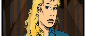
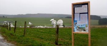
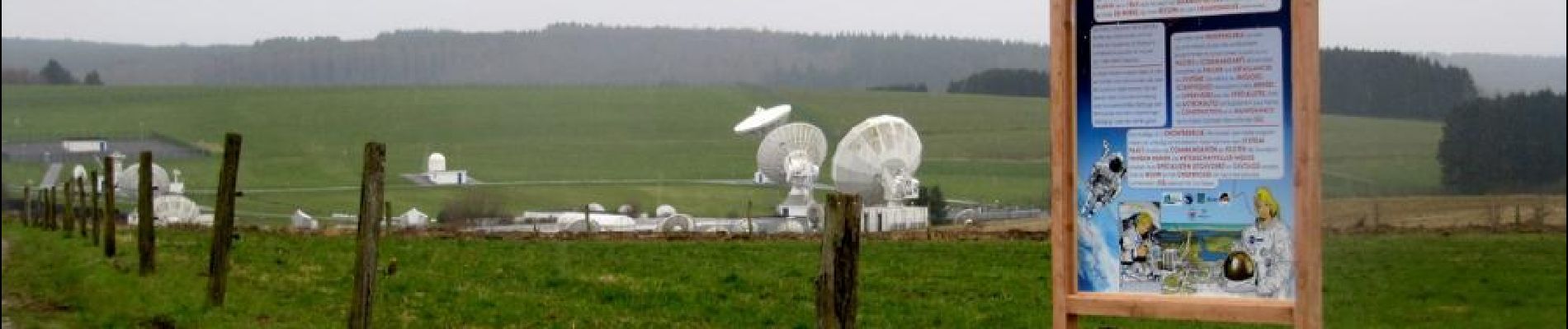
Tania, de heldin uit het stripverhaal van Pierre-Emmanuel Paulis, is de mascotte van een nieuwe, interactieve ontdekkingstocht te Redu. Met een roadbook of een tablet kunt u Tania vergezellen bij haar ontmoeting met verhaalfiguren uit de streek en kunt u haar helpen om de raadsels op te lossen. Een originele, speelse en interactieve wandeling in Redu en omgeving.
Verkrijgbaar bij het Maison du Tourisme du Pays de la Haute-Lesse.
 "
data-pinterest-text="Pin it"
data-tweet-text="share on twitter"
data-facebook-share-url="https://www.sitytrail.com/nl/trails/378986-libin--redu-x-ontdekkingstocht-xtania-tussen-de-legendenx/?photo=1#lg=1&slide=1"
data-twitter-share-url="https://www.sitytrail.com/nl/trails/378986-libin--redu-x-ontdekkingstocht-xtania-tussen-de-legendenx/?photo=1#lg=1&slide=1"
data-googleplus-share-url="https://www.sitytrail.com/nl/trails/378986-libin--redu-x-ontdekkingstocht-xtania-tussen-de-legendenx/?photo=1#lg=1&slide=1"
data-pinterest-share-url="https://www.sitytrail.com/nl/trails/378986-libin--redu-x-ontdekkingstocht-xtania-tussen-de-legendenx/?photo=1#lg=1&slide=1">
"
data-pinterest-text="Pin it"
data-tweet-text="share on twitter"
data-facebook-share-url="https://www.sitytrail.com/nl/trails/378986-libin--redu-x-ontdekkingstocht-xtania-tussen-de-legendenx/?photo=1#lg=1&slide=1"
data-twitter-share-url="https://www.sitytrail.com/nl/trails/378986-libin--redu-x-ontdekkingstocht-xtania-tussen-de-legendenx/?photo=1#lg=1&slide=1"
data-googleplus-share-url="https://www.sitytrail.com/nl/trails/378986-libin--redu-x-ontdekkingstocht-xtania-tussen-de-legendenx/?photo=1#lg=1&slide=1"
data-pinterest-share-url="https://www.sitytrail.com/nl/trails/378986-libin--redu-x-ontdekkingstocht-xtania-tussen-de-legendenx/?photo=1#lg=1&slide=1">
 "
data-pinterest-text="Pin it"
data-tweet-text="share on twitter"
data-facebook-share-url="https://www.sitytrail.com/nl/trails/378986-libin--redu-x-ontdekkingstocht-xtania-tussen-de-legendenx/?photo=2#lg=1&slide=2"
data-twitter-share-url="https://www.sitytrail.com/nl/trails/378986-libin--redu-x-ontdekkingstocht-xtania-tussen-de-legendenx/?photo=2#lg=1&slide=2"
data-googleplus-share-url="https://www.sitytrail.com/nl/trails/378986-libin--redu-x-ontdekkingstocht-xtania-tussen-de-legendenx/?photo=2#lg=1&slide=2"
data-pinterest-share-url="https://www.sitytrail.com/nl/trails/378986-libin--redu-x-ontdekkingstocht-xtania-tussen-de-legendenx/?photo=2#lg=1&slide=2">
"
data-pinterest-text="Pin it"
data-tweet-text="share on twitter"
data-facebook-share-url="https://www.sitytrail.com/nl/trails/378986-libin--redu-x-ontdekkingstocht-xtania-tussen-de-legendenx/?photo=2#lg=1&slide=2"
data-twitter-share-url="https://www.sitytrail.com/nl/trails/378986-libin--redu-x-ontdekkingstocht-xtania-tussen-de-legendenx/?photo=2#lg=1&slide=2"
data-googleplus-share-url="https://www.sitytrail.com/nl/trails/378986-libin--redu-x-ontdekkingstocht-xtania-tussen-de-legendenx/?photo=2#lg=1&slide=2"
data-pinterest-share-url="https://www.sitytrail.com/nl/trails/378986-libin--redu-x-ontdekkingstocht-xtania-tussen-de-legendenx/?photo=2#lg=1&slide=2">
 "
data-pinterest-text="Pin it"
data-tweet-text="share on twitter"
data-facebook-share-url="https://www.sitytrail.com/nl/trails/378986-libin--redu-x-ontdekkingstocht-xtania-tussen-de-legendenx/?photo=3#lg=1&slide=3"
data-twitter-share-url="https://www.sitytrail.com/nl/trails/378986-libin--redu-x-ontdekkingstocht-xtania-tussen-de-legendenx/?photo=3#lg=1&slide=3"
data-googleplus-share-url="https://www.sitytrail.com/nl/trails/378986-libin--redu-x-ontdekkingstocht-xtania-tussen-de-legendenx/?photo=3#lg=1&slide=3"
data-pinterest-share-url="https://www.sitytrail.com/nl/trails/378986-libin--redu-x-ontdekkingstocht-xtania-tussen-de-legendenx/?photo=3#lg=1&slide=3">
"
data-pinterest-text="Pin it"
data-tweet-text="share on twitter"
data-facebook-share-url="https://www.sitytrail.com/nl/trails/378986-libin--redu-x-ontdekkingstocht-xtania-tussen-de-legendenx/?photo=3#lg=1&slide=3"
data-twitter-share-url="https://www.sitytrail.com/nl/trails/378986-libin--redu-x-ontdekkingstocht-xtania-tussen-de-legendenx/?photo=3#lg=1&slide=3"
data-googleplus-share-url="https://www.sitytrail.com/nl/trails/378986-libin--redu-x-ontdekkingstocht-xtania-tussen-de-legendenx/?photo=3#lg=1&slide=3"
data-pinterest-share-url="https://www.sitytrail.com/nl/trails/378986-libin--redu-x-ontdekkingstocht-xtania-tussen-de-legendenx/?photo=3#lg=1&slide=3">
 "
data-pinterest-text="Pin it"
data-tweet-text="share on twitter"
data-facebook-share-url="https://www.sitytrail.com/nl/trails/378986-libin--redu-x-ontdekkingstocht-xtania-tussen-de-legendenx/?photo=4#lg=1&slide=4"
data-twitter-share-url="https://www.sitytrail.com/nl/trails/378986-libin--redu-x-ontdekkingstocht-xtania-tussen-de-legendenx/?photo=4#lg=1&slide=4"
data-googleplus-share-url="https://www.sitytrail.com/nl/trails/378986-libin--redu-x-ontdekkingstocht-xtania-tussen-de-legendenx/?photo=4#lg=1&slide=4"
data-pinterest-share-url="https://www.sitytrail.com/nl/trails/378986-libin--redu-x-ontdekkingstocht-xtania-tussen-de-legendenx/?photo=4#lg=1&slide=4">
"
data-pinterest-text="Pin it"
data-tweet-text="share on twitter"
data-facebook-share-url="https://www.sitytrail.com/nl/trails/378986-libin--redu-x-ontdekkingstocht-xtania-tussen-de-legendenx/?photo=4#lg=1&slide=4"
data-twitter-share-url="https://www.sitytrail.com/nl/trails/378986-libin--redu-x-ontdekkingstocht-xtania-tussen-de-legendenx/?photo=4#lg=1&slide=4"
data-googleplus-share-url="https://www.sitytrail.com/nl/trails/378986-libin--redu-x-ontdekkingstocht-xtania-tussen-de-legendenx/?photo=4#lg=1&slide=4"
data-pinterest-share-url="https://www.sitytrail.com/nl/trails/378986-libin--redu-x-ontdekkingstocht-xtania-tussen-de-legendenx/?photo=4#lg=1&slide=4">


Stappen

Stappen

Stappen

Stappen

Stappen

Stappen

Stappen

Stappen

Stappen