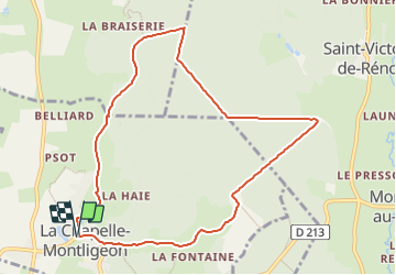
![](/images/other/stat-length.png)
![Tocht Stappen La Chapelle-Montligeon - [Itinéraire] La ligne du Tram - Photo](https://media.geolcdn.com/t/1900/400/ext.pjpeg?maxdim=2&url=https%3A%2F%2Fstatic1.geolcdn.com%2Fsiteimages%2Fupload%2Ffiles%2F1553511878bg_sport_marche.png)
[Itinéraire] La ligne du Tram
ODDAD78
Gebruiker
![Lengte](/images/other/stat-length.png)
![Max. hoogte](https://static1.geolcdn.com/siteimages/upload/files/1508320355ic_sort_altitude_max_24dp.png)
![Positief hoogteverschil](https://static1.geolcdn.com/siteimages/upload/files/1508320355ic_sort_den_pos_24dp.png)
![Km-Effort](/images/other/stat-length.png)
![Min. hoogte](https://static1.geolcdn.com/siteimages/upload/files/1508320355ic_sort_altitude_min_24dp.png)
![Negatief hoogteverschil](https://static1.geolcdn.com/siteimages/upload/files/1508320355ic_sort_den_neg_24dp.png)
![Boucle](https://static1.geolcdn.com/siteimages/upload/files/16400158638029165_repeat_loop_refresh_sync_direction_icon.png)
![Stappen](https://static1.geolcdn.com/sitytour/trail-icons/101.png)
2h37
Moeilijkheid : Medium
![Scan deze QR-code om de tocht te openen in de SityTrail-applicatie](https://capi.geolives.com/qq0zvz2zws4bq2lad0pu/sitytour/trails/3784577/qr.png?size=200)
Gratisgps-wandelapplicatie
Over ons
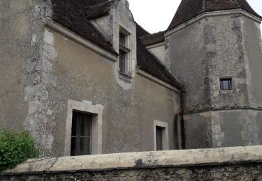
Tocht Stappen van 9,2 km beschikbaar op Normandië, Orne, La Chapelle-Montligeon. Deze tocht wordt voorgesteld door ODDAD78.
Beschrijving
Départ : La Chapelle-Montligeon Arrivée : La Chapelle-Montligeon Balisage : PR
Communes : 1. La Chapelle-Montligeon 2. Saint-Victor-de-Réno
3. Saint-Mard-de-Réno
Partir par le haut de la Rue Principale. Au sommet de la côte prendre à gauche le petit chemin goudronné.
1. Dans le premier lacet, monter par le chemin empierré à forte pente. Continuer tout droit pour gagner le carrefour forestier de La Croix Fourmi.
2. Poursuivre en face jusqu’au hameau du Courthenou. A la sortie du hameau prendre à gauche en direction de l’Etre Blossier.
3. Prendre le premier chemin à droite qui traverse un ruisseau, puis, raviné et sinueux mène au creux d’un vallon forestier. Monter à gauche l’allée en forte pente.
4. Arrivé en haut, emprunter à droite la grande allée entre les parcelles 98 et 99. Au Carrefour de La Haslerie, traverser l’allée goudronnée et poursuivre en face vers le hameau de La Haslerie.
5. Au bas de la descente, suivre un petit chemin vers la gauche qui mène bientôt à une allée empierrée vers le Carrefour des Grands Ordons. Prendre ensuite la ligne empierrée à droite. Au Carrefour des Fontenelles, suivre à droite l’allée goudronnée sur 350 m.
6. Tourner à gauche au premier chemin (barrière), (ancienne ligne du tram Mortagne – La Loupe). Suivre cette voie, traverser une allée forestière, continuer tout droit à la croisée de 4 chemins (passage humide) Après une courbe encaissée poursuivre tout droit.
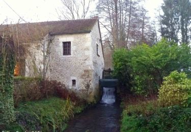
7. Au lieu-dit Le Pavillon, au sortir de la forêt, passer sur l’ancien pont du chemin de fer. Au hameau de La Picherie, traverser la route goudronnée. A un virage à droite, passer entre deux maisons et prendre aussitôt à gauche. A la bifurcation suivante, à droite vers le lotissement de La Ronderie. A la route goudronnée, à gauche, passer devant le lavoir pour arriver dans le bourg.
(Pas à pas : Rando-Perche)
Plaatsbepaling
Opmerkingen
Wandeltochten in de omgeving
![Tocht Stappen Longny les Villages - Monceaux au Perche (Boucle) - Photo](https://media.geolcdn.com/t/375/260/ext.jpg?maxdim=2&url=https%3A%2F%2Fstatic1.geolcdn.com%2Fsiteimages%2Fupload%2Ffiles%2F1553511878bg_sport_marche.png)
![Stappen Stappen](https://static1.geolcdn.com/sitytour/trail-icons/101.png)
Stappen
![](/images/other/stat-length.png)
![](https://static1.geolcdn.com/siteimages/upload/files/16400158638029165_repeat_loop_refresh_sync_direction_icon.png)
![Tocht Te voet Longny les Villages - Attelage - Forêt et Panoramas - forêt de Réno-Valdieu - Photo](https://media.geolcdn.com/t/375/260/db99a0ed-9413-4500-8368-446623bccd86.jpeg&format=jpg&maxdim=2)
![Te voet Te voet](https://static1.geolcdn.com/sitytour/trail-icons/100.png)
Te voet
![](/images/other/stat-length.png)
![](https://static1.geolcdn.com/siteimages/upload/files/16400158638029165_repeat_loop_refresh_sync_direction_icon.png)
![Tocht Stappen La Chapelle-Montligeon - [Itinéraire] Le Mont Ligeon - Photo](https://media.geolcdn.com/t/375/260/ce92da88-fb92-411f-965d-5e4e270d0f79.jpeg&format=jpg&maxdim=2)
![Stappen Stappen](https://static1.geolcdn.com/sitytour/trail-icons/101.png)
Stappen
![](/images/other/stat-length.png)
![](https://static1.geolcdn.com/siteimages/upload/files/16400158638029165_repeat_loop_refresh_sync_direction_icon.png)
![Tocht Stappen Cour-Maugis sur Huisne - 12102996-Maison Maugis 22.37 - Photo](https://media.geolcdn.com/t/375/260/ext.jpg?maxdim=2&url=https%3A%2F%2Fstatic1.geolcdn.com%2Fsiteimages%2Fupload%2Ffiles%2F1553511878bg_sport_marche.png)
![Stappen Stappen](https://static1.geolcdn.com/sitytour/trail-icons/101.png)
Stappen
![](/images/other/stat-length.png)
![](https://static1.geolcdn.com/siteimages/upload/files/16400158638029165_repeat_loop_refresh_sync_direction_icon.png)
![Tocht Stappen La Chapelle-Montligeon - La Chapelle-Montligeon - Longny-au-Perche via Bizou 16 km - Photo](https://media.geolcdn.com/t/375/260/5e36f740-ecc7-4760-b425-4f15cc356d54.jpg&format=jpg&maxdim=2)
![Stappen Stappen](https://static1.geolcdn.com/sitytour/trail-icons/101.png)
Stappen
![](/images/other/stat-length.png)
![](https://static1.geolcdn.com/siteimages/upload/files/16400158638029165_repeat_loop_refresh_sync_direction_icon.png)
![Tocht Stappen La Chapelle-Montligeon - La Chapelle-Montligeon - Moutiers-au-Perche via Bizou 20 km - Photo](https://media.geolcdn.com/t/375/260/4094c967-a97a-44d3-924e-010e9be9049f.jpg&format=jpg&maxdim=2)
![Stappen Stappen](https://static1.geolcdn.com/sitytour/trail-icons/101.png)
Stappen
![](/images/other/stat-length.png)
![](https://static1.geolcdn.com/siteimages/upload/files/16400158638029165_repeat_loop_refresh_sync_direction_icon.png)
![Tocht Stappen La Chapelle-Montligeon - La Chapelle-Montligeon - Le Mage via Bizou 18 km - Photo](https://media.geolcdn.com/t/375/260/2514d07f-ce42-4914-ba12-eb561f06fea2.jpg&format=jpg&maxdim=2)
![Stappen Stappen](https://static1.geolcdn.com/sitytour/trail-icons/101.png)
Stappen
![](/images/other/stat-length.png)
![](https://static1.geolcdn.com/siteimages/upload/files/16400158638029165_repeat_loop_refresh_sync_direction_icon.png)
![Tocht Stappen Longny les Villages - Monceaux et le Manoir - Photo](https://media.geolcdn.com/t/375/260/2c895f3a-5924-449a-a873-4ad274746411.jpg&format=jpg&maxdim=2)
![Stappen Stappen](https://static1.geolcdn.com/sitytour/trail-icons/101.png)
Stappen
![](/images/other/stat-length.png)
![](https://static1.geolcdn.com/siteimages/upload/files/16400158638029165_repeat_loop_refresh_sync_direction_icon.png)
![Tocht Stappen Longny les Villages - Minceaux 2 - Photo](https://media.geolcdn.com/t/375/260/7d79a233-230a-4321-b3f2-9bfbb749ff7a.jpg&format=jpg&maxdim=2)
![Stappen Stappen](https://static1.geolcdn.com/sitytour/trail-icons/101.png)
Stappen
![](/images/other/stat-length.png)
![](https://static1.geolcdn.com/siteimages/upload/files/16400158638029165_repeat_loop_refresh_sync_direction_icon.png)