![](/images/other/stat-length.png)
![Tocht Stappen Auvers-Saint-Georges - Auvers-Saint-Georges - Photo](https://media.geolcdn.com/t/1900/400/94651cc4-eb6a-4aac-ab8a-ddf377c2df63.jpg&format=pjpeg&maxdim=2)
Auvers-Saint-Georges
guydu41
Gebruiker
![Lengte](/images/other/stat-length.png)
Lengte
8,3 km
![Max. hoogte](https://static1.geolcdn.com/siteimages/upload/files/1508320355ic_sort_altitude_max_24dp.png)
Max. hoogte
148 m
![Positief hoogteverschil](https://static1.geolcdn.com/siteimages/upload/files/1508320355ic_sort_den_pos_24dp.png)
Positief hoogteverschil
149 m
![Km-Effort](/images/other/stat-length.png)
Km-Effort
10,3 km
![Min. hoogte](https://static1.geolcdn.com/siteimages/upload/files/1508320355ic_sort_altitude_min_24dp.png)
Min. hoogte
70 m
![Negatief hoogteverschil](https://static1.geolcdn.com/siteimages/upload/files/1508320355ic_sort_den_neg_24dp.png)
Negatief hoogteverschil
150 m
![Boucle](https://static1.geolcdn.com/siteimages/upload/files/16400158638029165_repeat_loop_refresh_sync_direction_icon.png)
Boucle
Ja
Datum van aanmaak :
2023-08-18 07:18:57.624
Laatste wijziging :
2023-08-19 20:49:18.596
![Stappen](https://static1.geolcdn.com/sitytour/trail-icons/101.png)
2h20
Moeilijkheid : Medium
![Scan deze QR-code om de tocht te openen in de SityTrail-applicatie](https://capi.geolives.com/qq0zvz2zws4bq2lad0pu/sitytour/trails/3776028/qr.png?size=200)
Gratisgps-wandelapplicatie
Over ons
Tocht Stappen van 8,3 km beschikbaar op Île-de-France, Essonne, Auvers-Saint-Georges. Deze tocht wordt voorgesteld door guydu41.
Beschrijving
Beau circuit principalement sur des chemins et sentiers à travers bois.
Possibilité de faire un petit crochet pour admirer de très beaux chevaux d'un haras.
Plaatsbepaling
Land:
France
Regio :
Île-de-France
Departement/Provincie :
Essonne
Gemeente :
Auvers-Saint-Georges
Locatie:
Unknown
Vertrek:(Dec)
Vertrek:(UTM)
442755 ; 5371732 (31U) N.
Opmerkingen
Wandeltochten in de omgeving
![Tocht Stappen Lardy - Lardy - Chamarande -F - Photo](https://media.geolcdn.com/t/375/260/ext.jpg?maxdim=2&url=https%3A%2F%2Fservices.sitytrail.com%2FGeolivesWS%2FDownloadMedia.ashx%3FTrailID%3D274259%26Media%3Dfix__20140504142726.jpg)
![Stappen Stappen](https://static1.geolcdn.com/sitytour/trail-icons/101.png)
Lardy - Chamarande -F
Stappen
Medium
(2)
Lardy,
Île-de-France,
Essonne,
France
![](/images/other/stat-length.png)
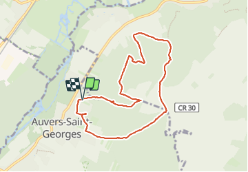
18,3 km | 22 km-effort
4h 44min
![](https://static1.geolcdn.com/siteimages/upload/files/16400158638029165_repeat_loop_refresh_sync_direction_icon.png)
Ja
![Tocht Stappen Lardy - Autour de Lardy par la Pierre levée de Janville sur Juine - Photo](https://media.geolcdn.com/t/375/260/ext.jpg?maxdim=2&url=https%3A%2F%2Fservices.sitytrail.com%2FGeolivesWS%2FDownloadMedia.ashx%3FTrailID%3D110136%26Media%3D5334_1.jpg)
![Stappen Stappen](https://static1.geolcdn.com/sitytour/trail-icons/101.png)
Autour de Lardy par la Pierre levée de Janville sur Juine
Stappen
Moeilijk
(1)
Lardy,
Île-de-France,
Essonne,
France
![](/images/other/stat-length.png)
24 km | 29 km-effort
4h 49min
![](https://static1.geolcdn.com/siteimages/upload/files/16400158638029165_repeat_loop_refresh_sync_direction_icon.png)
Ja
![Tocht Mountainbike Lardy - Autour de Lardy en VTT - Photo](https://media.geolcdn.com/t/375/260/ext.jpg?maxdim=2&url=https%3A%2F%2Fservices.sitytrail.com%2FGeolivesWS%2FDownloadMedia.ashx%3FTrailID%3D104079%26Media%3D7075_1.jpg)
![Mountainbike Mountainbike](https://static1.geolcdn.com/sitytour/trail-icons/202.png)
Autour de Lardy en VTT
Mountainbike
Medium
(1)
Lardy,
Île-de-France,
Essonne,
France
![](/images/other/stat-length.png)
31 km | 38 km-effort
2h 4min
![](https://static1.geolcdn.com/siteimages/upload/files/16400158638029165_repeat_loop_refresh_sync_direction_icon.png)
Ja
![Tocht Te voet Étréchy - Linéaire Etrechy - Dourdan - Photo](https://media.geolcdn.com/t/375/260/6933a6b2-3858-4fb1-ab0c-7f731489899d.jpg&format=jpg&maxdim=2)
![Te voet Te voet](https://static1.geolcdn.com/sitytour/trail-icons/100.png)
Linéaire Etrechy - Dourdan
Te voet
Medium
Étréchy,
Île-de-France,
Essonne,
France
![](/images/other/stat-length.png)
26 km | 31 km-effort
7h 3min
![](https://static1.geolcdn.com/siteimages/upload/files/16400158638029165_repeat_loop_refresh_sync_direction_icon.png)
Neen
![Tocht Stappen Chamarande - bois de belvedere au depart de chamarande - Photo](https://media.geolcdn.com/t/375/260/ext.jpg?maxdim=2&url=https%3A%2F%2Fstatic1.geolcdn.com%2Fsiteimages%2Fupload%2Ffiles%2F1553511878bg_sport_marche.png)
![Stappen Stappen](https://static1.geolcdn.com/sitytour/trail-icons/101.png)
bois de belvedere au depart de chamarande
Stappen
Moeilijk
(1)
Chamarande,
Île-de-France,
Essonne,
France
![](/images/other/stat-length.png)
12,6 km | 17,2 km-effort
3h 54min
![](https://static1.geolcdn.com/siteimages/upload/files/16400158638029165_repeat_loop_refresh_sync_direction_icon.png)
Ja
![Tocht Te voet Lardy - Boucle Lardy par Pascale - Photo](https://media.geolcdn.com/t/375/260/fcd0ce26-70c7-4c63-8ed6-22b96bedd69d.jpg&format=jpg&maxdim=2)
![Te voet Te voet](https://static1.geolcdn.com/sitytour/trail-icons/100.png)
Boucle Lardy par Pascale
Te voet
Gemakkelijk
Lardy,
Île-de-France,
Essonne,
France
![](/images/other/stat-length.png)
20 km | 25 km-effort
5h 36min
![](https://static1.geolcdn.com/siteimages/upload/files/16400158638029165_repeat_loop_refresh_sync_direction_icon.png)
Ja
![Tocht Te voet Auvers-Saint-Georges - Au grès de la Juine - Photo](https://media.geolcdn.com/t/375/260/72c017b2-4cbc-4eae-9d9f-90478ed2d91b.jpeg&format=jpg&maxdim=2)
![Te voet Te voet](https://static1.geolcdn.com/sitytour/trail-icons/100.png)
Au grès de la Juine
Te voet
Medium
Auvers-Saint-Georges,
Île-de-France,
Essonne,
France
![](/images/other/stat-length.png)
22 km | 27 km-effort
6h 10min
![](https://static1.geolcdn.com/siteimages/upload/files/16400158638029165_repeat_loop_refresh_sync_direction_icon.png)
Neen
![Tocht Stappen Étréchy - Boucle de 2 jours au départ d'Etréchy via Etampes Chalo St Mars - Photo](https://media.geolcdn.com/t/375/260/ext.jpg?maxdim=2&url=https%3A%2F%2Fstatic1.geolcdn.com%2Fsiteimages%2Fupload%2Ffiles%2F1553511878bg_sport_marche.png)
![Stappen Stappen](https://static1.geolcdn.com/sitytour/trail-icons/101.png)
Boucle de 2 jours au départ d'Etréchy via Etampes Chalo St Mars
Stappen
Zeer moeilijk
(1)
Étréchy,
Île-de-France,
Essonne,
France
![](/images/other/stat-length.png)
42 km | 51 km-effort
11h 28min
![](https://static1.geolcdn.com/siteimages/upload/files/16400158638029165_repeat_loop_refresh_sync_direction_icon.png)
Ja
![Tocht Stappen Boissy-le-Cutté - Boucle autour de Boissy le Cuté par Thierry - Photo](https://media.geolcdn.com/t/375/260/336908cd-9ec6-484b-afe2-dd1a5cf591f1.jpg&format=jpg&maxdim=2)
![Stappen Stappen](https://static1.geolcdn.com/sitytour/trail-icons/101.png)
Boucle autour de Boissy le Cuté par Thierry
Stappen
Gemakkelijk
Boissy-le-Cutté,
Île-de-France,
Essonne,
France
![](/images/other/stat-length.png)
29 km | 35 km-effort
5h 44min
![](https://static1.geolcdn.com/siteimages/upload/files/16400158638029165_repeat_loop_refresh_sync_direction_icon.png)
Ja