![](/images/other/stat-length.png)
![Tocht Stappen Laroque-des-Albères - RP66 - LAROQUE - ST GENIS - EV8 - VILLELONGUE - MONTESQUIEU - Voie Verte -ST GENIS - LAROQUE - Photo](https://media.geolcdn.com/t/1900/400/b92d1c14-cdfd-4963-a97d-0f3d981aaf1d.jpg&format=pjpeg&maxdim=2)
RP66 - LAROQUE - ST GENIS - EV8 - VILLELONGUE - MONTESQUIEU - Voie Verte -ST GENIS - LAROQUE
jeff66
Gebruiker
![Lengte](/images/other/stat-length.png)
![Max. hoogte](https://static1.geolcdn.com/siteimages/upload/files/1508320355ic_sort_altitude_max_24dp.png)
![Positief hoogteverschil](https://static1.geolcdn.com/siteimages/upload/files/1508320355ic_sort_den_pos_24dp.png)
![Km-Effort](/images/other/stat-length.png)
![Min. hoogte](https://static1.geolcdn.com/siteimages/upload/files/1508320355ic_sort_altitude_min_24dp.png)
![Negatief hoogteverschil](https://static1.geolcdn.com/siteimages/upload/files/1508320355ic_sort_den_neg_24dp.png)
![Boucle](https://static1.geolcdn.com/siteimages/upload/files/16400158638029165_repeat_loop_refresh_sync_direction_icon.png)
![Stappen](https://static1.geolcdn.com/sitytour/trail-icons/101.png)
2h21
Moeilijkheid : Moeilijk
![Scan deze QR-code om de tocht te openen in de SityTrail-applicatie](https://capi.geolives.com/qq0zvz2zws4bq2lad0pu/sitytour/trails/3773725/qr.png?size=200)
Gratisgps-wandelapplicatie
Over ons
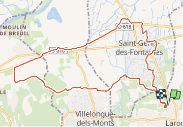
Tocht Stappen van 13,9 km beschikbaar op Occitanië, Pyrénées-Orientales, Laroque-des-Albères. Deze tocht wordt voorgesteld door jeff66.
Beschrijving
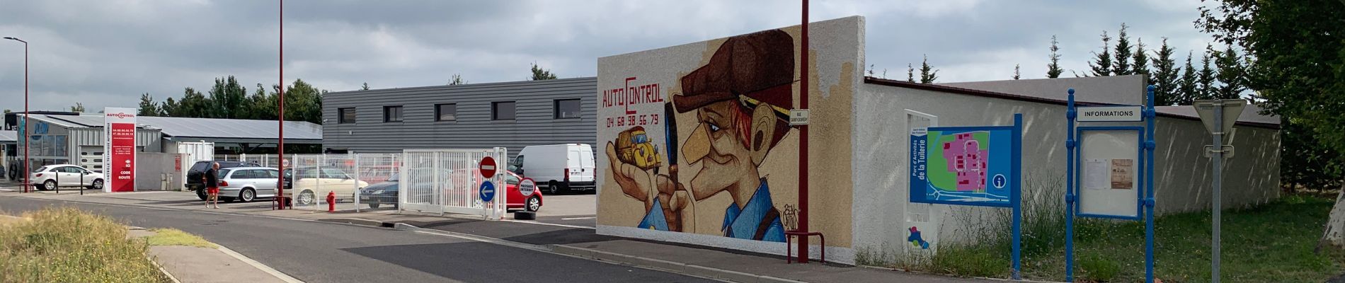
RP66 - LAROQUE - les vernèdes - antenne - ST GENIS - VILLELONGUE - EV8 - cavall d’en Boix - la RIVIERE - croisement D61a - EV8 direction Montesquieu - domaine des Luque - station épuration - passerelle sur RIVIERE de Villemongue - gué Correc de Riba - mas d’en Bernat - traverse de VILLELONGUE - mas Fabrega - rue de la Plansounade - rue longue - chateau de MONTESQUIEU - garage Mas - longer D618 - camp d’en Roua - mas d’en Ferrer - passer sous D618 - Voie Verte - lycée Alfred Sauvy - El pla - jardins familiaux - piste ULM - écurie sant Jordi - Isolasud - la distillerie - chemin des Vignerons - ST GENIS - SME - ZA de la tuilerie - La Prade - hôtel des ville - LAROQUE
Plaatsbepaling
Opmerkingen
Wandeltochten in de omgeving
![Tocht Stappen Laroque-des-Albères - Laroque-des-Albères, petit tour des mas - Photo](https://media.geolcdn.com/t/375/260/a38763d0-1e12-4df0-8310-6577414297bd.jpg&format=jpg&maxdim=2)
![Stappen Stappen](https://static1.geolcdn.com/sitytour/trail-icons/101.png)
Stappen
![](/images/other/stat-length.png)
![](https://static1.geolcdn.com/siteimages/upload/files/16400158638029165_repeat_loop_refresh_sync_direction_icon.png)
![Tocht Stappen Laroque-des-Albères - 66 LAROQUE DES ALBERES (maison) SOREDE, par pistes DFCI AL12 et 19, mas del Ca et mas Manere, Itin.16 - Photo](https://media.geolcdn.com/t/375/260/ext.jpg?maxdim=2&url=https%3A%2F%2Fservices.sitytrail.com%2FGeolivesWS%2FDownloadMedia.ashx%3FTrailID%3D585179%26Media%3D20160616145650.jpg)
![Stappen Stappen](https://static1.geolcdn.com/sitytour/trail-icons/101.png)
Stappen
![](/images/other/stat-length.png)
![](https://static1.geolcdn.com/siteimages/upload/files/16400158638029165_repeat_loop_refresh_sync_direction_icon.png)
![Tocht Stappen Laroque-des-Albères - 66 SOREDE, LAROQUE DES ALBERES, chemins des Mas - Photo](https://media.geolcdn.com/t/375/260/ext.jpg?maxdim=2&url=https%3A%2F%2Fservices.sitytrail.com%2FGeolivesWS%2FDownloadMedia.ashx%3FTrailID%3D534699%26Media%3D20160303171633.jpg)
![Stappen Stappen](https://static1.geolcdn.com/sitytour/trail-icons/101.png)
Stappen
![](/images/other/stat-length.png)
![](https://static1.geolcdn.com/siteimages/upload/files/16400158638029165_repeat_loop_refresh_sync_direction_icon.png)
![Tocht Stappen Saint-André - 66 SAINT-ANDRE - SOREDE - chapelle Saint Ferreol de la Pava - Photo](https://media.geolcdn.com/t/375/260/ext.jpg?maxdim=2&url=https%3A%2F%2Fservices.sitytrail.com%2FGeolivesWS%2FDownloadMedia.ashx%3FTrailID%3D455673%26Media%3D20150807175253.jpg)
![Stappen Stappen](https://static1.geolcdn.com/sitytour/trail-icons/101.png)
Stappen
![](/images/other/stat-length.png)
![](https://static1.geolcdn.com/siteimages/upload/files/16400158638029165_repeat_loop_refresh_sync_direction_icon.png)
![Tocht Stappen L'Albère - SAINT-JEAN-D'ALBERE 66 - PUIG de Sant Christau par le coll de Sant Joan - Photo](https://media.geolcdn.com/t/375/260/ext.jpg?maxdim=2&url=https%3A%2F%2Fservices.sitytrail.com%2FGeolivesWS%2FDownloadMedia.ashx%3FTrailID%3D452444%26Media%3D20150731170134.jpg)
![Stappen Stappen](https://static1.geolcdn.com/sitytour/trail-icons/101.png)
Stappen
![](/images/other/stat-length.png)
![](https://static1.geolcdn.com/siteimages/upload/files/16400158638029165_repeat_loop_refresh_sync_direction_icon.png)
![Tocht Stappen Montesquieu-des-Albères - MONTESQUIEU-DES-ALBERES 66 - Les Agouillous - les chemins de l'eau dans les Albères - Photo](https://media.geolcdn.com/t/375/260/ext.jpg?maxdim=2&url=https%3A%2F%2Fservices.sitytrail.com%2FGeolivesWS%2FDownloadMedia.ashx%3FTrailID%3D451257%26Media%3D20150728182708.jpg)
![Stappen Stappen](https://static1.geolcdn.com/sitytour/trail-icons/101.png)
Stappen
![](/images/other/stat-length.png)
![](https://static1.geolcdn.com/siteimages/upload/files/16400158638029165_repeat_loop_refresh_sync_direction_icon.png)
![Tocht Stappen Palau-del-Vidre - PALAU-DEL-VIDRE 66 - Boucle de Villeclare - promenade dans les vergers et cultures maraîchères - Photo](https://media.geolcdn.com/t/375/260/ext.jpg?maxdim=2&url=https%3A%2F%2Fservices.sitytrail.com%2FGeolivesWS%2FDownloadMedia.ashx%3FTrailID%3D426910%26Media%3D20150528155048.jpg)
![Stappen Stappen](https://static1.geolcdn.com/sitytour/trail-icons/101.png)
Stappen
![](/images/other/stat-length.png)
![](https://static1.geolcdn.com/siteimages/upload/files/16400158638029165_repeat_loop_refresh_sync_direction_icon.png)
![Tocht Stappen Sorède - Utrera Font Miracles T - Photo](https://media.geolcdn.com/t/375/260/ext.jpg?maxdim=2&url=https%3A%2F%2Fservices.sitytrail.com%2FGeolivesWS%2FDownloadMedia.ashx%3FTrailID%3D419352%26Media%3Dfix__20150510145313.jpg)
![Stappen Stappen](https://static1.geolcdn.com/sitytour/trail-icons/101.png)
Stappen
![](/images/other/stat-length.png)
![](https://static1.geolcdn.com/siteimages/upload/files/16400158638029165_repeat_loop_refresh_sync_direction_icon.png)
![Tocht Stappen Sorède - 577. 11km sorede roc des medes - Photo](https://media.geolcdn.com/t/375/260/61f4e75a-7c25-4df1-b192-fc8eca3c7acc.jpg&format=jpg&maxdim=2)
![Stappen Stappen](https://static1.geolcdn.com/sitytour/trail-icons/101.png)
Stappen
![](/images/other/stat-length.png)
![](https://static1.geolcdn.com/siteimages/upload/files/16400158638029165_repeat_loop_refresh_sync_direction_icon.png)