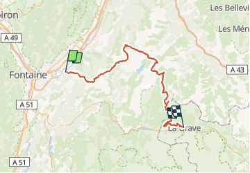
![](/images/other/stat-length.png)
![Tocht Stappen Domène - Traversée belledone - Photo](https://media.geolcdn.com/t/1900/400/ext.pjpeg?maxdim=2&url=https%3A%2F%2Fstatic1.geolcdn.com%2Fsiteimages%2Fupload%2Ffiles%2F1553511878bg_sport_marche.png)
Traversée belledone
camleco
Gebruiker
![Lengte](/images/other/stat-length.png)
![Max. hoogte](https://static1.geolcdn.com/siteimages/upload/files/1508320355ic_sort_altitude_max_24dp.png)
![Positief hoogteverschil](https://static1.geolcdn.com/siteimages/upload/files/1508320355ic_sort_den_pos_24dp.png)
![Km-Effort](/images/other/stat-length.png)
![Min. hoogte](https://static1.geolcdn.com/siteimages/upload/files/1508320355ic_sort_altitude_min_24dp.png)
![Negatief hoogteverschil](https://static1.geolcdn.com/siteimages/upload/files/1508320355ic_sort_den_neg_24dp.png)
![Boucle](https://static1.geolcdn.com/siteimages/upload/files/16400158638029165_repeat_loop_refresh_sync_direction_icon.png)
![Stappen](https://static1.geolcdn.com/sitytour/trail-icons/101.png)
47h55
Moeilijkheid : Zeer moeilijk
![Scan deze QR-code om de tocht te openen in de SityTrail-applicatie](https://capi.geolives.com/qq0zvz2zws4bq2lad0pu/sitytour/trails/3770761/qr.png?size=200)
Gratisgps-wandelapplicatie
Over ons
Tocht Stappen van 103 km beschikbaar op Auvergne-Rhône-Alpes, Isère, Domène. Deze tocht wordt voorgesteld door camleco.
Beschrijving
Vendredi Jour 1 : Brive la gaillarde - Grenoble - Domène
- Train 6h/15h15
- Bus 15 (22min gare/préfecture 32 min bus 15 Domène mairie (bus toutes les 17 min))
Domène - Lac du Crozet ( 1800m / 15 km / 4h30)
• Sac : Diner
Samedi Jour 2 : Lac du Crozet - Brèche de Roche Fendue - Lac de la Coche
( 300 / -200 m / 14 km / 6h)
• Sac : Petit déj picnique diner
Dimanche Jour 3 : Lac de la Coche - Col de l'Ile? - Refuge de la Combe Madame
( 1000 m / -500 m / 20 km / 7h)
• Sac : Petit déj picnique
• Refuge : diner (18€)
Lundi Jour 4 : Refuge de la Combe - Refuge de l'étendard
( 1400m / -750m / 15km / 7h //31kme)
• Sac : Petit déj diner
• Refuge : picnique (10€)
Mardi Jour 5 : Refuge de l'étendard - Cime de la Valette par les crêtes - Bergerie de Tirequeue
( 850 m / -1000 m / 16 km / 6h20 //28kme)
• Sac : Petit déj picnique diner
Mercredi Jour 6 : Bergerie de Tirequeue - Cime des Torches par les crêtes - Pic du Mas de la Grave - le Gros Têt - Refuge du pic du mas de la grave (3h30 de montée jusqu'au pic : partir à 5h00 du mat)
( 900 m / -1350 m / 14 km / 6h10 //27kme)
• Sac : Petit déj
• Refuge : Midi (12€) diner (21€) 3€
Jeudi Jour 7 : Refuge du pic du mas de la grave - lac noir - La Grave (partir à 6h30)
( 140m / -600m / 16 km / 4h30 //20kme)
• Sac : Petit déj restes
La Grave - Grenoble - Compiègne
- Bus 55 10h/11h47 ou 12h51/14h30
- Train 16h45/21h30
Plaatsbepaling
Opmerkingen
Wandeltochten in de omgeving
![Tocht Te voet Saint-Martin-d'Uriage - Balcon de Combeloup - Photo](https://media.geolcdn.com/t/375/260/67f211a9-4659-4ac8-8551-19ac88e52f68.jpeg&format=jpg&maxdim=2)
![Te voet Te voet](https://static1.geolcdn.com/sitytour/trail-icons/100.png)
Te voet
![](/images/other/stat-length.png)
![](https://static1.geolcdn.com/siteimages/upload/files/16400158638029165_repeat_loop_refresh_sync_direction_icon.png)
![Tocht Te voet La Combe-de-Lancey - Chemin de Découverte (boucle Basse) - Photo](https://media.geolcdn.com/t/375/260/6915f95f-b034-4e84-88aa-9ed85af7f443.jpeg&format=jpg&maxdim=2)
![Te voet Te voet](https://static1.geolcdn.com/sitytour/trail-icons/100.png)
Te voet
![](/images/other/stat-length.png)
![](https://static1.geolcdn.com/siteimages/upload/files/16400158638029165_repeat_loop_refresh_sync_direction_icon.png)
![Tocht Te voet La Combe-de-Lancey - Chemin de Découverte (boucle Haute) - Photo](https://media.geolcdn.com/t/375/260/6a0cb0d1-93da-4068-99ad-9a549161cacf.jpeg&format=jpg&maxdim=2)
![Te voet Te voet](https://static1.geolcdn.com/sitytour/trail-icons/100.png)
Te voet
![](/images/other/stat-length.png)
![](https://static1.geolcdn.com/siteimages/upload/files/16400158638029165_repeat_loop_refresh_sync_direction_icon.png)
![Tocht Te voet Domène - Domène à Murianette, par les rives de l'Isère - Photo](https://media.geolcdn.com/t/375/260/f00f3b3d-abcc-47f4-9cc6-e5ee52a8ddd2.jpeg&format=jpg&maxdim=2)
![Te voet Te voet](https://static1.geolcdn.com/sitytour/trail-icons/100.png)
Te voet
![](/images/other/stat-length.png)
![](https://static1.geolcdn.com/siteimages/upload/files/16400158638029165_repeat_loop_refresh_sync_direction_icon.png)
![Tocht Te voet Domène - Circuit de Beauregard - Photo](https://media.geolcdn.com/t/375/260/c0d86b6a-ec41-4f3c-879d-1fb6f4151878.jpeg&format=jpg&maxdim=2)
![Te voet Te voet](https://static1.geolcdn.com/sitytour/trail-icons/100.png)
Te voet
![](/images/other/stat-length.png)
![](https://static1.geolcdn.com/siteimages/upload/files/16400158638029165_repeat_loop_refresh_sync_direction_icon.png)
![Tocht Te voet Domène - Circuit de la Monta - Photo](https://media.geolcdn.com/t/375/260/8f502881-e98d-4929-b19b-6c8e9cb279e5.jpeg&format=jpg&maxdim=2)
![Te voet Te voet](https://static1.geolcdn.com/sitytour/trail-icons/100.png)
Te voet
![](/images/other/stat-length.png)
![](https://static1.geolcdn.com/siteimages/upload/files/16400158638029165_repeat_loop_refresh_sync_direction_icon.png)
![Tocht Te voet Saint-Jean-le-Vieux - La Tour de Revel (par le Mollard) - Photo](https://media.geolcdn.com/t/375/260/9b2599de-7f79-405c-8210-bdfecfa7c849.jpeg&format=jpg&maxdim=2)
![Te voet Te voet](https://static1.geolcdn.com/sitytour/trail-icons/100.png)
Te voet
![](/images/other/stat-length.png)
![](https://static1.geolcdn.com/siteimages/upload/files/16400158638029165_repeat_loop_refresh_sync_direction_icon.png)
![Tocht Te voet Gières - De Gières au col du Gourlu - Photo](https://media.geolcdn.com/t/375/260/b782ea79-2f14-452c-9af6-76dad2fec664.jpeg&format=jpg&maxdim=2)
![Te voet Te voet](https://static1.geolcdn.com/sitytour/trail-icons/100.png)
Te voet
![](/images/other/stat-length.png)
![](https://static1.geolcdn.com/siteimages/upload/files/16400158638029165_repeat_loop_refresh_sync_direction_icon.png)
![Tocht Mountainbike Domène - Domène, grande boucle : la Bourjat - bois de l'envers - grands bois - Photo](https://media.geolcdn.com/t/375/260/ext.jpg?maxdim=2&url=https%3A%2F%2Fstatic1.geolcdn.com%2Fsiteimages%2Fupload%2Ffiles%2F1524743154velo.jpg)
![Mountainbike Mountainbike](https://static1.geolcdn.com/sitytour/trail-icons/202.png)
Mountainbike
![](/images/other/stat-length.png)
![](https://static1.geolcdn.com/siteimages/upload/files/16400158638029165_repeat_loop_refresh_sync_direction_icon.png)