![](/images/other/stat-length.png)
![Tocht Stappen Aubignosc - aubignosc. les canyons. partie basse - Photo](https://media.geolcdn.com/t/1900/400/458f68cb-7d82-4bdf-ba0e-6e04edac884f.jpg&format=pjpeg&maxdim=2)
aubignosc. les canyons. partie basse
Roger
Gebruiker
![Lengte](/images/other/stat-length.png)
Lengte
7,9 km
![Max. hoogte](https://static1.geolcdn.com/siteimages/upload/files/1508320355ic_sort_altitude_max_24dp.png)
Max. hoogte
604 m
![Positief hoogteverschil](https://static1.geolcdn.com/siteimages/upload/files/1508320355ic_sort_den_pos_24dp.png)
Positief hoogteverschil
239 m
![Km-Effort](/images/other/stat-length.png)
Km-Effort
11,1 km
![Min. hoogte](https://static1.geolcdn.com/siteimages/upload/files/1508320355ic_sort_altitude_min_24dp.png)
Min. hoogte
461 m
![Negatief hoogteverschil](https://static1.geolcdn.com/siteimages/upload/files/1508320355ic_sort_den_neg_24dp.png)
Negatief hoogteverschil
238 m
![Boucle](https://static1.geolcdn.com/siteimages/upload/files/16400158638029165_repeat_loop_refresh_sync_direction_icon.png)
Boucle
Ja
Datum van aanmaak :
2023-08-07 05:52:04.791
Laatste wijziging :
2023-08-07 08:58:25.521
![Stappen](https://static1.geolcdn.com/sitytour/trail-icons/101.png)
2h50
Moeilijkheid : Medium
![Scan deze QR-code om de tocht te openen in de SityTrail-applicatie](https://capi.geolives.com/qq0zvz2zws4bq2lad0pu/sitytour/trails/3761771/qr.png?size=200)
Gratisgps-wandelapplicatie
Over ons
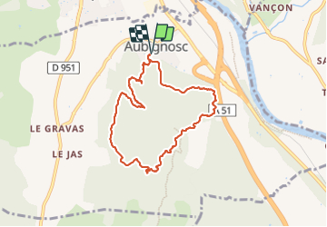
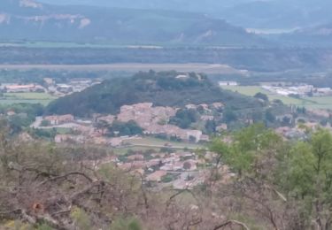
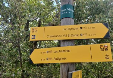
Tocht Stappen van 7,9 km beschikbaar op Provence-Alpes-Côte d'Azur, Alpes-de-Haute-Provence, Aubignosc. Deze tocht wordt voorgesteld door Roger .
Beschrijving
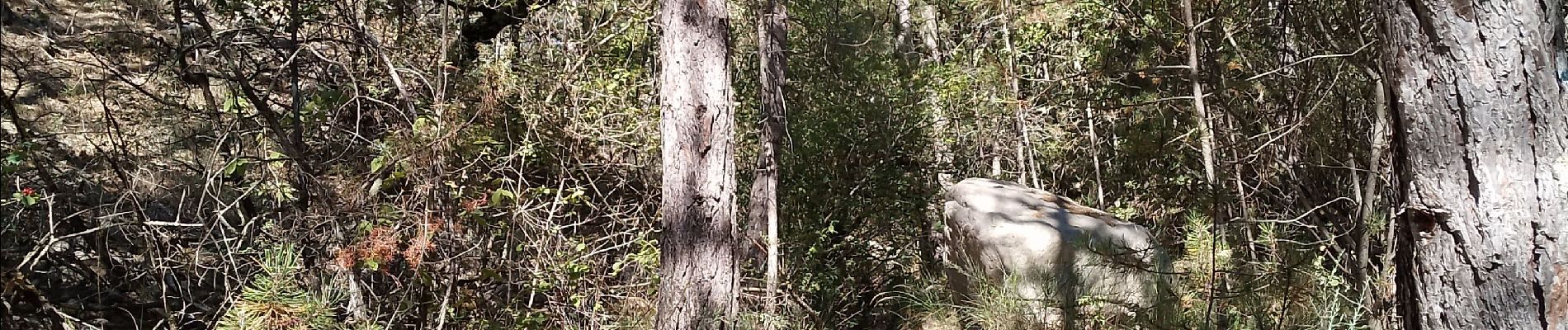
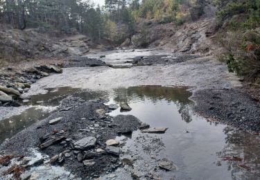
belle randonnée. départ un peu chamoteux du fait du nombres de sentiers. a la fin il vaut mieux prendre la piste, car la remontée du ru n est pas évidente.difficile à se repérer
Plaatsbepaling
Land:
France
Regio :
Provence-Alpes-Côte d'Azur
Departement/Provincie :
Alpes-de-Haute-Provence
Gemeente :
Aubignosc
Locatie:
Unknown
Vertrek:(Dec)
Vertrek:(UTM)
737487 ; 4890451 (31T) N.
Opmerkingen
Wandeltochten in de omgeving
![Tocht Stappen Peipin - PEIPIN . PAR LES CHEMINS ABANDONNÉS DE PEIPIN O L S - Photo](https://media.geolcdn.com/t/375/260/7475f192-1a04-4ae2-85f2-46dfbe426939.jpg&format=jpg&maxdim=2)
![Stappen Stappen](https://static1.geolcdn.com/sitytour/trail-icons/101.png)
PEIPIN . PAR LES CHEMINS ABANDONNÉS DE PEIPIN O L S
Stappen
Medium
(1)
Peipin,
Provence-Alpes-Côte d'Azur,
Alpes-de-Haute-Provence,
France
![](/images/other/stat-length.png)
9 km | 17,7 km-effort
2h 46min
![](https://static1.geolcdn.com/siteimages/upload/files/16400158638029165_repeat_loop_refresh_sync_direction_icon.png)
Ja
![Tocht Stappen Aubignosc - AUBIGNOSC. Vieil Chateau Neuf , canyons o l m s - Photo](https://media.geolcdn.com/t/375/260/65ebcf05-a4c8-4543-8e63-050694c809e9.jpg&format=jpg&maxdim=2)
![Stappen Stappen](https://static1.geolcdn.com/sitytour/trail-icons/101.png)
AUBIGNOSC. Vieil Chateau Neuf , canyons o l m s
Stappen
Gemakkelijk
(1)
Aubignosc,
Provence-Alpes-Côte d'Azur,
Alpes-de-Haute-Provence,
France
![](/images/other/stat-length.png)
12,6 km | 17,6 km-effort
3h 33min
![](https://static1.geolcdn.com/siteimages/upload/files/16400158638029165_repeat_loop_refresh_sync_direction_icon.png)
Ja
![Tocht Stappen Aubignosc - AUBIGNOSC . LE PETIT COLORADO . O L S - Photo](https://media.geolcdn.com/t/375/260/9769e6c8-7278-4da5-a931-29d787d20283.jpg&format=jpg&maxdim=2)
![Stappen Stappen](https://static1.geolcdn.com/sitytour/trail-icons/101.png)
AUBIGNOSC . LE PETIT COLORADO . O L S
Stappen
Medium
(1)
Aubignosc,
Provence-Alpes-Côte d'Azur,
Alpes-de-Haute-Provence,
France
![](/images/other/stat-length.png)
8,3 km | 11,3 km-effort
2h 36min
![](https://static1.geolcdn.com/siteimages/upload/files/16400158638029165_repeat_loop_refresh_sync_direction_icon.png)
Ja
![Tocht Stappen Châteauneuf-Val-Saint-Donat - CHÂTEAU NEUF VAL SAINT DONAT. Circuit des bories o l s - Photo](https://media.geolcdn.com/t/375/260/8821efa2-5581-41ec-b1c9-8e88d2e8f706.jpg&format=jpg&maxdim=2)
![Stappen Stappen](https://static1.geolcdn.com/sitytour/trail-icons/101.png)
CHÂTEAU NEUF VAL SAINT DONAT. Circuit des bories o l s
Stappen
Medium
(1)
Châteauneuf-Val-Saint-Donat,
Provence-Alpes-Côte d'Azur,
Alpes-de-Haute-Provence,
France
![](/images/other/stat-length.png)
6,6 km | 9,6 km-effort
1h 57min
![](https://static1.geolcdn.com/siteimages/upload/files/16400158638029165_repeat_loop_refresh_sync_direction_icon.png)
Ja
![Tocht Stappen Châteauneuf-Val-Saint-Donat - CHÂTEAU NEUF VAL SAINT DONAT . Vieux village , voie Romaine o l s o - Photo](https://media.geolcdn.com/t/375/260/103fcb20-d34f-4e88-ac50-6ebe3201aea7.jpg&format=jpg&maxdim=2)
![Stappen Stappen](https://static1.geolcdn.com/sitytour/trail-icons/101.png)
CHÂTEAU NEUF VAL SAINT DONAT . Vieux village , voie Romaine o l s o
Stappen
Gemakkelijk
(1)
Châteauneuf-Val-Saint-Donat,
Provence-Alpes-Côte d'Azur,
Alpes-de-Haute-Provence,
France
![](/images/other/stat-length.png)
7,8 km | 10 km-effort
1h 57min
![](https://static1.geolcdn.com/siteimages/upload/files/16400158638029165_repeat_loop_refresh_sync_direction_icon.png)
Ja
![Tocht Stappen Château-Arnoux-Saint-Auban - CHATEAU ARNOUX. S Jean , chemin des Bruyères, les Grandes Côtes o l s - Photo](https://media.geolcdn.com/t/375/260/053ba967-5713-4669-b325-8e9d67549d6c.jpg&format=jpg&maxdim=2)
![Stappen Stappen](https://static1.geolcdn.com/sitytour/trail-icons/101.png)
CHATEAU ARNOUX. S Jean , chemin des Bruyères, les Grandes Côtes o l s
Stappen
Medium
(1)
Château-Arnoux-Saint-Auban,
Provence-Alpes-Côte d'Azur,
Alpes-de-Haute-Provence,
France
![](/images/other/stat-length.png)
14,5 km | 21 km-effort
4h 46min
![](https://static1.geolcdn.com/siteimages/upload/files/16400158638029165_repeat_loop_refresh_sync_direction_icon.png)
Ja
![Tocht Stappen Châteauneuf-Val-Saint-Donat - Bergeries en pierres sèches - Châteauneuf Val Saint Donat - Photo](https://media.geolcdn.com/t/375/260/ext.jpg?maxdim=2&url=https%3A%2F%2Fservices.sitytrail.com%2FGeolivesWS%2FDownloadMedia.ashx%3FTrailID%3D107740%26Media%3D12806_6.jpg)
![Stappen Stappen](https://static1.geolcdn.com/sitytour/trail-icons/101.png)
Bergeries en pierres sèches - Châteauneuf Val Saint Donat
Stappen
Medium
(2)
Châteauneuf-Val-Saint-Donat,
Provence-Alpes-Côte d'Azur,
Alpes-de-Haute-Provence,
France
![](/images/other/stat-length.png)
7,6 km | 11,2 km-effort
2h 19min
![](https://static1.geolcdn.com/siteimages/upload/files/16400158638029165_repeat_loop_refresh_sync_direction_icon.png)
Ja
![Tocht Stappen Peipin - PEIPIN . aubignosc. Le vieux village Château Neuf Val Saint Donnât par GR7 o 53D - Photo](https://media.geolcdn.com/t/375/260/ext.jpg?maxdim=2&url=https%3A%2F%2Fstatic1.geolcdn.com%2Fsiteimages%2Fupload%2Ffiles%2F1553511878bg_sport_marche.png)
![Stappen Stappen](https://static1.geolcdn.com/sitytour/trail-icons/101.png)
PEIPIN . aubignosc. Le vieux village Château Neuf Val Saint Donnât par GR7 o...
Stappen
Gemakkelijk
(1)
Peipin,
Provence-Alpes-Côte d'Azur,
Alpes-de-Haute-Provence,
France
![](/images/other/stat-length.png)
13,5 km | 18,3 km-effort
3h 44min
![](https://static1.geolcdn.com/siteimages/upload/files/16400158638029165_repeat_loop_refresh_sync_direction_icon.png)
Ja
![Tocht Lopen Volonne - les 2 sommets sr Jean et tigne - Photo](https://media.geolcdn.com/t/375/260/ext.jpg?maxdim=2&url=https%3A%2F%2Fservices.sitytrail.com%2FGeolivesWS%2FDownloadMedia.ashx%3FTrailID%3D506279%26Media%3Dfix__20151226163303.jpg)
![Lopen Lopen](https://static1.geolcdn.com/sitytour/trail-icons/103.png)
les 2 sommets sr Jean et tigne
Lopen
Medium
(1)
Volonne,
Provence-Alpes-Côte d'Azur,
Alpes-de-Haute-Provence,
France
![](/images/other/stat-length.png)
10,4 km | 16,2 km-effort
1h 7min
![](https://static1.geolcdn.com/siteimages/upload/files/16400158638029165_repeat_loop_refresh_sync_direction_icon.png)
Ja