![](/images/other/stat-length.png)
![Tocht Stappen Goxwiller - Goxwiller-Landsberg-Kapellenhausfelsen-Goxwiller - Photo](https://media.geolcdn.com/t/1900/400/390ed298-4d20-49ef-b006-7362b0424779.jpg&format=pjpeg&maxdim=2)
Goxwiller-Landsberg-Kapellenhausfelsen-Goxwiller
Silke Roth
Gebruiker
![Lengte](/images/other/stat-length.png)
Lengte
17,7 km
![Max. hoogte](https://static1.geolcdn.com/siteimages/upload/files/1508320355ic_sort_altitude_max_24dp.png)
Max. hoogte
740 m
![Positief hoogteverschil](https://static1.geolcdn.com/siteimages/upload/files/1508320355ic_sort_den_pos_24dp.png)
Positief hoogteverschil
619 m
![Km-Effort](/images/other/stat-length.png)
Km-Effort
26 km
![Min. hoogte](https://static1.geolcdn.com/siteimages/upload/files/1508320355ic_sort_altitude_min_24dp.png)
Min. hoogte
166 m
![Negatief hoogteverschil](https://static1.geolcdn.com/siteimages/upload/files/1508320355ic_sort_den_neg_24dp.png)
Negatief hoogteverschil
633 m
![Boucle](https://static1.geolcdn.com/siteimages/upload/files/16400158638029165_repeat_loop_refresh_sync_direction_icon.png)
Boucle
Neen
Datum van aanmaak :
2023-07-29 07:31:48.0
Laatste wijziging :
2023-07-29 12:27:16.606
![Stappen](https://static1.geolcdn.com/sitytour/trail-icons/101.png)
4h30
Moeilijkheid : Medium
![Scan deze QR-code om de tocht te openen in de SityTrail-applicatie](https://capi.geolives.com/qq0zvz2zws4bq2lad0pu/sitytour/trails/3751126/qr.png?size=200)
Gratisgps-wandelapplicatie
Over ons
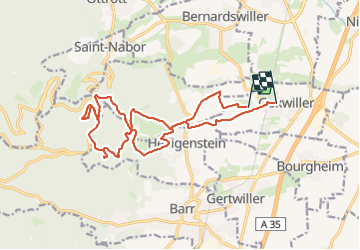
Tocht Stappen van 17,7 km beschikbaar op Grand Est, Bas-Rhin, Goxwiller. Deze tocht wordt voorgesteld door Silke Roth.
Beschrijving
Boucle de randonnée
Départ de la gare de Goxwiller
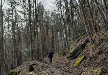
Vignes puis forêt
Visite des ruines du château du Lansberg
Pause au rocher du Kappellenhausfelsen
Retour à Goxwiller
Plaatsbepaling
Land:
France
Regio :
Grand Est
Departement/Provincie :
Bas-Rhin
Gemeente :
Goxwiller
Locatie:
Unknown
Vertrek:(Dec)
Vertrek:(UTM)
386974 ; 5365449 (32U) N.
Opmerkingen
Wandeltochten in de omgeving
![Tocht Stappen Ottrott - Le Mont Sainte-Odile depuis Otrott - Photo](https://media.geolcdn.com/t/375/260/ext.jpg?maxdim=2&url=https%3A%2F%2Fservices.sitytrail.com%2FGeolivesWS%2FDownloadMedia.ashx%3FTrailID%3D506359%26Media%3Dfix__20151226143401.jpg)
![Stappen Stappen](https://static1.geolcdn.com/sitytour/trail-icons/101.png)
Le Mont Sainte-Odile depuis Otrott
Stappen
Medium
(1)
Ottrott,
Grand Est,
Bas-Rhin,
France
![](/images/other/stat-length.png)
13 km | 20 km-effort
6h 18min
![](https://static1.geolcdn.com/siteimages/upload/files/16400158638029165_repeat_loop_refresh_sync_direction_icon.png)
Ja
![Tocht Stappen Obernai - Obernai gare - Mont St Odile - Photo](https://media.geolcdn.com/t/375/260/ext.jpg?maxdim=2&url=https%3A%2F%2Fservices.sitytrail.com%2FGeolivesWS%2FDownloadMedia.ashx%3FTrailID%3D172386%26Media%3D13734_3.jpg)
![Stappen Stappen](https://static1.geolcdn.com/sitytour/trail-icons/101.png)
Obernai gare - Mont St Odile
Stappen
Moeilijk
(2)
Obernai,
Grand Est,
Bas-Rhin,
France
![](/images/other/stat-length.png)
20 km | 29 km-effort
5h 0min
![](https://static1.geolcdn.com/siteimages/upload/files/16400158638029165_repeat_loop_refresh_sync_direction_icon.png)
Ja
![Tocht Mountainbike Ottrott - Sainte-Odile East-Face - Photo](https://media.geolcdn.com/t/375/260/ext.jpg?maxdim=2&url=https%3A%2F%2Fservices.sitytrail.com%2FGeolivesWS%2FDownloadMedia.ashx%3FTrailID%3D100800%26Media%3D307_1.jpg)
![Mountainbike Mountainbike](https://static1.geolcdn.com/sitytour/trail-icons/202.png)
Sainte-Odile East-Face
Mountainbike
Moeilijk
(1)
Ottrott,
Grand Est,
Bas-Rhin,
France
![](/images/other/stat-length.png)
24 km | 39 km-effort
3h 0min
![](https://static1.geolcdn.com/siteimages/upload/files/16400158638029165_repeat_loop_refresh_sync_direction_icon.png)
Ja
![Tocht Stappen Mittelbergheim - Boucle des châteaux d'Andlau et du Sepsbourg - Photo](https://media.geolcdn.com/t/375/260/d5048da0-192e-4551-9ea6-7d5710ee4aab.jpg&format=jpg&maxdim=2)
![Stappen Stappen](https://static1.geolcdn.com/sitytour/trail-icons/101.png)
Boucle des châteaux d'Andlau et du Sepsbourg
Stappen
Medium
Mittelbergheim,
Grand Est,
Bas-Rhin,
France
![](/images/other/stat-length.png)
9,3 km | 13 km-effort
2h 27min
![](https://static1.geolcdn.com/siteimages/upload/files/16400158638029165_repeat_loop_refresh_sync_direction_icon.png)
Ja
![Tocht Stappen Obernai - sentier des merveilles - Photo](https://media.geolcdn.com/t/375/260/ext.jpg?maxdim=2&url=https%3A%2F%2Fservices.sitytrail.com%2FGeolivesWS%2FDownloadMedia.ashx%3FTrailID%3D566156%26Media%3Dfix__20160504152906.jpg)
![Stappen Stappen](https://static1.geolcdn.com/sitytour/trail-icons/101.png)
sentier des merveilles
Stappen
Moeilijk
(1)
Obernai,
Grand Est,
Bas-Rhin,
France
![](/images/other/stat-length.png)
11 km | 16,6 km-effort
4h 8min
![](https://static1.geolcdn.com/siteimages/upload/files/16400158638029165_repeat_loop_refresh_sync_direction_icon.png)
Ja
![Tocht Stappen Mittelbergheim - Mittelbergheim - Château du Landsberg - Photo](https://media.geolcdn.com/t/375/260/ext.jpg?maxdim=2&url=https%3A%2F%2Fstatic1.geolcdn.com%2Fsiteimages%2Fupload%2Ffiles%2F1553511878bg_sport_marche.png)
![Stappen Stappen](https://static1.geolcdn.com/sitytour/trail-icons/101.png)
Mittelbergheim - Château du Landsberg
Stappen
Medium
(3)
Mittelbergheim,
Grand Est,
Bas-Rhin,
France
![](/images/other/stat-length.png)
15,4 km | 23 km-effort
5h 0min
![](https://static1.geolcdn.com/siteimages/upload/files/16400158638029165_repeat_loop_refresh_sync_direction_icon.png)
Ja
![Tocht Stappen Bœrsch - 2024-01 Klingenthal-Heidenkopf - Photo](https://media.geolcdn.com/t/375/260/a991b2e6-da04-4fd7-a864-361e7379c8ee.jpg&format=jpg&maxdim=2)
![Stappen Stappen](https://static1.geolcdn.com/sitytour/trail-icons/101.png)
2024-01 Klingenthal-Heidenkopf
Stappen
Medium
Bœrsch,
Grand Est,
Bas-Rhin,
France
![](/images/other/stat-length.png)
10,9 km | 17,3 km-effort
2h 42min
![](https://static1.geolcdn.com/siteimages/upload/files/16400158638029165_repeat_loop_refresh_sync_direction_icon.png)
Ja
![Tocht Stappen Saint-Nabor - circuit anciennes abbayes - Photo](https://media.geolcdn.com/t/375/260/6e0ec479-8d74-404c-b33f-f5b415513d37.jpg&format=jpg&maxdim=2)
![Stappen Stappen](https://static1.geolcdn.com/sitytour/trail-icons/101.png)
circuit anciennes abbayes
Stappen
Medium
(1)
Saint-Nabor,
Grand Est,
Bas-Rhin,
France
![](/images/other/stat-length.png)
35 km | 43 km-effort
5h 12min
![](https://static1.geolcdn.com/siteimages/upload/files/16400158638029165_repeat_loop_refresh_sync_direction_icon.png)
Neen
![Tocht Elektrische fiets Gertwiller - Barr - Photo](https://media.geolcdn.com/t/375/260/4d28c7ed-c56b-41f0-8052-9fcfcd8b23f8.jpg&format=jpg&maxdim=2)
![Elektrische fiets Elektrische fiets](https://static1.geolcdn.com/sitytour/trail-icons/205.png)
Barr
Elektrische fiets
Medium
Gertwiller,
Grand Est,
Bas-Rhin,
France
![](/images/other/stat-length.png)
58 km | 69 km-effort
3h 48min
![](https://static1.geolcdn.com/siteimages/upload/files/16400158638029165_repeat_loop_refresh_sync_direction_icon.png)
Neen