![](/images/other/stat-length.png)
![Tocht Elektrische fiets Aat - Entre la cité des géants et le château de Beloeil - Photo](https://media.geolcdn.com/t/1900/400/d42d3fbb-98cc-4c8a-abd4-2d757f22feb5.jpg&format=pjpeg&maxdim=2)
Entre la cité des géants et le château de Beloeil
Boubby
Gebruiker
![Lengte](/images/other/stat-length.png)
![Max. hoogte](https://static1.geolcdn.com/siteimages/upload/files/1508320355ic_sort_altitude_max_24dp.png)
![Positief hoogteverschil](https://static1.geolcdn.com/siteimages/upload/files/1508320355ic_sort_den_pos_24dp.png)
![Km-Effort](/images/other/stat-length.png)
![Min. hoogte](https://static1.geolcdn.com/siteimages/upload/files/1508320355ic_sort_altitude_min_24dp.png)
![Negatief hoogteverschil](https://static1.geolcdn.com/siteimages/upload/files/1508320355ic_sort_den_neg_24dp.png)
![Boucle](https://static1.geolcdn.com/siteimages/upload/files/16400158638029165_repeat_loop_refresh_sync_direction_icon.png)
![Elektrische fiets](https://static1.geolcdn.com/sitytour/trail-icons/205.png)
2h53
Moeilijkheid : Gemakkelijk
![Scan deze QR-code om de tocht te openen in de SityTrail-applicatie](https://capi.geolives.com/qq0zvz2zws4bq2lad0pu/sitytour/trails/3736446/qr.png?size=200)
Gratisgps-wandelapplicatie
Over ons
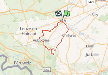
Tocht Elektrische fiets van 41 km beschikbaar op Wallonië, Henegouwen, Aat. Deze tocht wordt voorgesteld door Boubby.
Beschrijving
Chouette balade à vélo de -44km
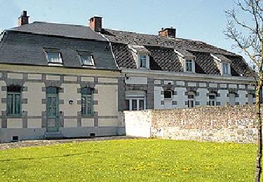
Ath, Cité des géants, est le point de départ d’une belle balade à vélo alliant culture et chemins de campagne. Démarrez votre visite devant la Maison des Géants. Vous rejoignez assez vite le RAVel 4 du Canal Blaton-Ath et profitez du calme des paysages verts longeant l’eau. Suivez les berges jusqu’à Beloeil et son magnifique Château. Ensuite, vous quittez le RAVeL pour poursuivre votre chemin à travers les paysages champêtres menant à Aubechies, l’un des plus beaux villages de Wallonie, et à son Archéosite®. Enfin, retour à Ath par les petites routes de campagne. A proximité, ne manquez pas l’un des plus anciens moulins encore en activité de la région, celui de la Marquise à Moulbaix.
Points-noeuds : DEPART 85 - 74 - 1 - 61 - 60 - 5 - 54 - 53 - 58 - 62 - 57 - 32 - 55 - 34 - 35 - 37 - 44 - 27 - 29 - 30 - 82 - 81 - 85 - 79 - 76 - 73 - 86 - 84 - 74 - 85 FIN
Plaatsbepaling
Opmerkingen
Wandeltochten in de omgeving
![Tocht Stappen Aat - GG2-Ha-26_Ath-Erbisoeul_2021-11-04 - Photo](https://media.geolcdn.com/t/375/260/92330c27-b822-40ac-9b26-3b2e2e0e14fe.jpg&format=jpg&maxdim=2)
![Stappen Stappen](https://static1.geolcdn.com/sitytour/trail-icons/101.png)
Stappen
![](/images/other/stat-length.png)
![](https://static1.geolcdn.com/siteimages/upload/files/16400158638029165_repeat_loop_refresh_sync_direction_icon.png)
![Tocht Te voet Aat - Kastelenroute - Photo](https://media.geolcdn.com/t/375/260/ext.jpg?maxdim=2&url=https%3A%2F%2Fpivotmedia.tourismewallonie.be%2FANX-02-04JL-028B%2FANX-02-04JL-028B.JPG)
![Te voet Te voet](https://static1.geolcdn.com/sitytour/trail-icons/100.png)
Te voet
![](/images/other/stat-length.png)
![](https://static1.geolcdn.com/siteimages/upload/files/16400158638029165_repeat_loop_refresh_sync_direction_icon.png)
![Tocht Te voet Aat - De Ronde van de Blanc Moulin - Photo](https://media.geolcdn.com/t/375/260/ext.jpg?maxdim=2&url=https%3A%2F%2Fpivotmedia.tourismewallonie.be%2FANX-02-000ELT%2FANX-02-000ELT.jpg)
![Te voet Te voet](https://static1.geolcdn.com/sitytour/trail-icons/100.png)
Te voet
![](/images/other/stat-length.png)
![](https://static1.geolcdn.com/siteimages/upload/files/16400158638029165_repeat_loop_refresh_sync_direction_icon.png)
![Tocht Te voet Aat - In de voetsporen van de steenhouwers - Photo](https://media.geolcdn.com/t/375/260/ext.jpg?maxdim=2&url=https%3A%2F%2Fpivotmedia.tourismewallonie.be%2FANX-02-04JL-01MH%2FANX-02-04JL-01MH.jpg)
![Te voet Te voet](https://static1.geolcdn.com/sitytour/trail-icons/100.png)
Te voet
![](/images/other/stat-length.png)
![](https://static1.geolcdn.com/siteimages/upload/files/16400158638029165_repeat_loop_refresh_sync_direction_icon.png)
![Tocht Te voet Aat - Het Molencircuit - Photo](https://media.geolcdn.com/t/375/260/ext.jpg?maxdim=2&url=https%3A%2F%2Fpivotmedia.tourismewallonie.be%2FANX-02-000EOC%2FANX-02-000EOC.jpg)
![Te voet Te voet](https://static1.geolcdn.com/sitytour/trail-icons/100.png)
Te voet
![](/images/other/stat-length.png)
![](https://static1.geolcdn.com/siteimages/upload/files/16400158638029165_repeat_loop_refresh_sync_direction_icon.png)
![Tocht Te voet Aat - Circuit van de Dendervlakte - Photo](https://media.geolcdn.com/t/375/260/ext.jpg?maxdim=2&url=https%3A%2F%2Fpivotmedia.tourismewallonie.be%2FANX-02-000ESY%2FANX-02-000ESY.jpg)
![Te voet Te voet](https://static1.geolcdn.com/sitytour/trail-icons/100.png)
Te voet
![](/images/other/stat-length.png)
![](https://static1.geolcdn.com/siteimages/upload/files/16400158638029165_repeat_loop_refresh_sync_direction_icon.png)
![Tocht Te voet Aat - Het Kapellencircuit - Photo](https://media.geolcdn.com/t/375/260/ext.jpg?maxdim=2&url=https%3A%2F%2Fpivotmedia.tourismewallonie.be%2FANX-02-000EST%2FANX-02-000EST.jpg)
![Te voet Te voet](https://static1.geolcdn.com/sitytour/trail-icons/100.png)
Te voet
![](/images/other/stat-length.png)
![](https://static1.geolcdn.com/siteimages/upload/files/16400158638029165_repeat_loop_refresh_sync_direction_icon.png)
![Tocht Te voet Aat - Circuit van de mysterieuze bomen - Photo](https://media.geolcdn.com/t/375/260/ext.jpg?maxdim=2&url=https%3A%2F%2Fpivotmedia.tourismewallonie.be%2FANX-02-03XZ-00B5%2FANX-02-03XZ-00B5.jpg)
![Te voet Te voet](https://static1.geolcdn.com/sitytour/trail-icons/100.png)
Te voet
![](/images/other/stat-length.png)
![](https://static1.geolcdn.com/siteimages/upload/files/16400158638029165_repeat_loop_refresh_sync_direction_icon.png)
![Tocht Stappen Aat - Ath FFBMP - Photo](https://media.geolcdn.com/t/375/260/09b382b0-6366-435d-8c9c-8a17083a918b.jpg&format=jpg&maxdim=2)
![Stappen Stappen](https://static1.geolcdn.com/sitytour/trail-icons/101.png)