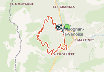
![](/images/other/stat-length.png)
![Tocht Stappen Pralognan-la-Vanoise - col de napremont - Photo](https://media.geolcdn.com/t/1900/400/6fea95cc-6da2-44f1-9ef9-b36a9d856ac2.jpg&format=pjpeg&maxdim=2)
col de napremont
amiral13
Gebruiker GUIDE
![Lengte](/images/other/stat-length.png)
![Max. hoogte](https://static1.geolcdn.com/siteimages/upload/files/1508320355ic_sort_altitude_max_24dp.png)
![Positief hoogteverschil](https://static1.geolcdn.com/siteimages/upload/files/1508320355ic_sort_den_pos_24dp.png)
![Km-Effort](/images/other/stat-length.png)
![Min. hoogte](https://static1.geolcdn.com/siteimages/upload/files/1508320355ic_sort_altitude_min_24dp.png)
![Negatief hoogteverschil](https://static1.geolcdn.com/siteimages/upload/files/1508320355ic_sort_den_neg_24dp.png)
![Boucle](https://static1.geolcdn.com/siteimages/upload/files/16400158638029165_repeat_loop_refresh_sync_direction_icon.png)
![Stappen](https://static1.geolcdn.com/sitytour/trail-icons/101.png)
4h24
Moeilijkheid : Gemakkelijk
![Scan deze QR-code om de tocht te openen in de SityTrail-applicatie](https://capi.geolives.com/qq0zvz2zws4bq2lad0pu/sitytour/trails/3719884/qr.png?size=200)
Gratisgps-wandelapplicatie
Over ons
Tocht Stappen van 9,4 km beschikbaar op Auvergne-Rhône-Alpes, Savoie, Pralognan-la-Vanoise. Deze tocht wordt voorgesteld door amiral13.
Beschrijving
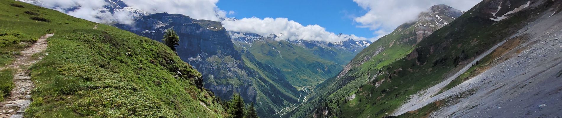
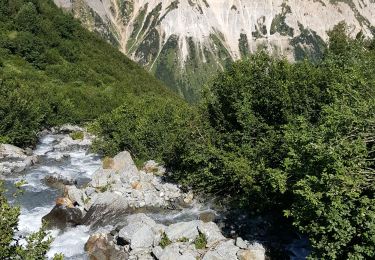
randonnée effectuée le 2 juillet 2023
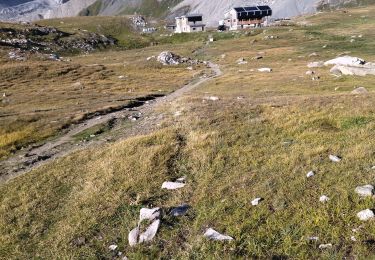
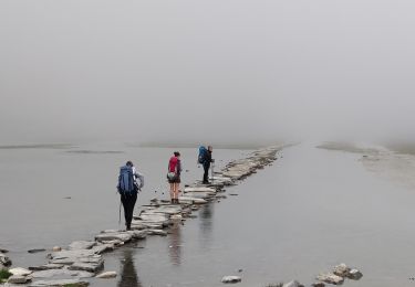
pour ceux qui sont sensibles au vertiges privilégiez le sens inverse de la randonnée de manière à monter les escaliers plutôt que de les descendre.
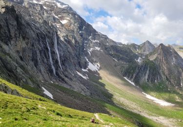
C'est un beau belvédère sur la Grande Casse malheureusement pour nous elle est restée dans son écrin de nuage toute la journée ; tout comme la Portetta et le grand bec.
Plaatsbepaling
Opmerkingen
Wandeltochten in de omgeving
![Tocht Stappen Pralognan-la-Vanoise - Pralognan - Les Prioux Lac de Chalet Clou - Photo](https://media.geolcdn.com/t/375/260/aef0b6ed-57e6-4d04-a75d-d2ffe6e61cd4.jpg&format=jpg&maxdim=2)
![Stappen Stappen](https://static1.geolcdn.com/sitytour/trail-icons/101.png)
Stappen
![](/images/other/stat-length.png)
![](https://static1.geolcdn.com/siteimages/upload/files/16400158638029165_repeat_loop_refresh_sync_direction_icon.png)
![Tocht Stappen Pralognan-la-Vanoise - Pralognan - la crête du mont Charvet - Photo](https://media.geolcdn.com/t/375/260/54cee105-6456-408f-be19-9af4b98c1ac1.jpg&format=jpg&maxdim=2)
![Stappen Stappen](https://static1.geolcdn.com/sitytour/trail-icons/101.png)
Stappen
![](/images/other/stat-length.png)
![](https://static1.geolcdn.com/siteimages/upload/files/16400158638029165_repeat_loop_refresh_sync_direction_icon.png)
![Tocht Stappen Val-Cenis - traversée Valette f faure - Photo](https://media.geolcdn.com/t/375/260/1679692e-b77c-47af-aee2-08c69ff92bec.jpg&format=jpg&maxdim=2)
![Stappen Stappen](https://static1.geolcdn.com/sitytour/trail-icons/101.png)
Stappen
![](/images/other/stat-length.png)
![](https://static1.geolcdn.com/siteimages/upload/files/16400158638029165_repeat_loop_refresh_sync_direction_icon.png)
![Tocht Stappen Pralognan-la-Vanoise - pointe de Leschaux - Photo](https://media.geolcdn.com/t/375/260/c0179711-7974-4489-9ffb-171084fcf8a1.jpg&format=jpg&maxdim=2)
![Stappen Stappen](https://static1.geolcdn.com/sitytour/trail-icons/101.png)
Stappen
![](/images/other/stat-length.png)
![](https://static1.geolcdn.com/siteimages/upload/files/16400158638029165_repeat_loop_refresh_sync_direction_icon.png)
![Tocht Stappen Planay - la cascade de la Vuzelle - Photo](https://media.geolcdn.com/t/375/260/04c5b92c-2692-443b-b1c5-903e48f44ec5.jpg&format=jpg&maxdim=2)
![Stappen Stappen](https://static1.geolcdn.com/sitytour/trail-icons/101.png)
Stappen
![](/images/other/stat-length.png)
![](https://static1.geolcdn.com/siteimages/upload/files/16400158638029165_repeat_loop_refresh_sync_direction_icon.png)
![Tocht Stappen Pralognan-la-Vanoise - traversée des Fontanettes aux Prioux par le col du Grand marchet - Photo](https://media.geolcdn.com/t/375/260/24a33514-db38-4400-a38f-98ffcbd53fe7.jpg&format=jpg&maxdim=2)
![Stappen Stappen](https://static1.geolcdn.com/sitytour/trail-icons/101.png)
Stappen
![](/images/other/stat-length.png)
![](https://static1.geolcdn.com/siteimages/upload/files/16400158638029165_repeat_loop_refresh_sync_direction_icon.png)
![Tocht Stappen Pralognan-la-Vanoise - le lac de la patinoire - Photo](https://media.geolcdn.com/t/375/260/88bae2e9-35f9-4ca5-a526-616594e07db8.jpg&format=jpg&maxdim=2)
![Stappen Stappen](https://static1.geolcdn.com/sitytour/trail-icons/101.png)
Stappen
![](/images/other/stat-length.png)
![](https://static1.geolcdn.com/siteimages/upload/files/16400158638029165_repeat_loop_refresh_sync_direction_icon.png)
![Tocht Stappen Pralognan-la-Vanoise - 2022-06-28 Marche TGV Refuge Valette Pralognan - Photo](https://media.geolcdn.com/t/375/260/64cb2300-ba57-4fac-bb37-92f95e3da956.jpg&format=jpg&maxdim=2)
![Stappen Stappen](https://static1.geolcdn.com/sitytour/trail-icons/101.png)
Stappen
![](/images/other/stat-length.png)
![](https://static1.geolcdn.com/siteimages/upload/files/16400158638029165_repeat_loop_refresh_sync_direction_icon.png)
![Tocht Stappen Pralognan-la-Vanoise - 2022-06-24 Marche TGV Pralognan Refuge du Col de la Vanoise - Photo](https://media.geolcdn.com/t/375/260/c4f04535-b0e5-45fd-a513-c3cb8f626a13.jpg&format=jpg&maxdim=2)
![Stappen Stappen](https://static1.geolcdn.com/sitytour/trail-icons/101.png)
Stappen
![](/images/other/stat-length.png)
![](https://static1.geolcdn.com/siteimages/upload/files/16400158638029165_repeat_loop_refresh_sync_direction_icon.png)