![](/images/other/stat-length.png)
![Tocht Stappen Saint-Laurent-en-Beaumont - Croix de la Roche et Signal St-Michel - Photo](https://media.geolcdn.com/t/1900/400/52236408-4d5b-4a9f-bbaa-7fca94a30aee.jpg&format=pjpeg&maxdim=2)
Croix de la Roche et Signal St-Michel
GuyVachet
Gebruiker
![Lengte](/images/other/stat-length.png)
![Max. hoogte](https://static1.geolcdn.com/siteimages/upload/files/1508320355ic_sort_altitude_max_24dp.png)
![Positief hoogteverschil](https://static1.geolcdn.com/siteimages/upload/files/1508320355ic_sort_den_pos_24dp.png)
![Km-Effort](/images/other/stat-length.png)
![Min. hoogte](https://static1.geolcdn.com/siteimages/upload/files/1508320355ic_sort_altitude_min_24dp.png)
![Negatief hoogteverschil](https://static1.geolcdn.com/siteimages/upload/files/1508320355ic_sort_den_neg_24dp.png)
![Boucle](https://static1.geolcdn.com/siteimages/upload/files/16400158638029165_repeat_loop_refresh_sync_direction_icon.png)
![Stappen](https://static1.geolcdn.com/sitytour/trail-icons/101.png)
5h54
Moeilijkheid : Zeer moeilijk
![Scan deze QR-code om de tocht te openen in de SityTrail-applicatie](https://capi.geolives.com/qq0zvz2zws4bq2lad0pu/sitytour/trails/3712202/qr.png?size=200)
Gratisgps-wandelapplicatie
Over ons
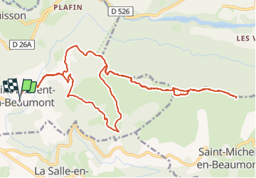
Tocht Stappen van 14,2 km beschikbaar op Auvergne-Rhône-Alpes, Isère, Saint-Laurent-en-Beaumont. Deze tocht wordt voorgesteld door GuyVachet.
Beschrijving
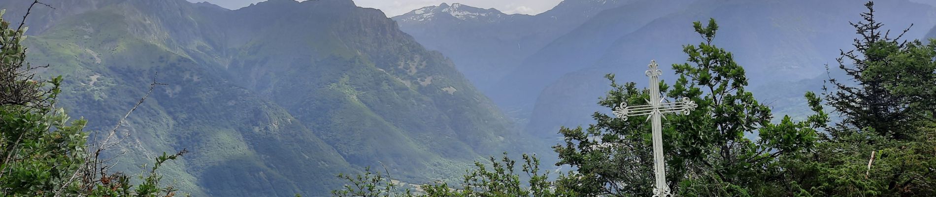
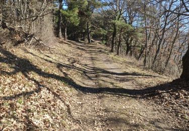
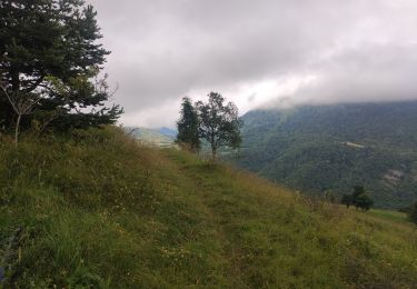
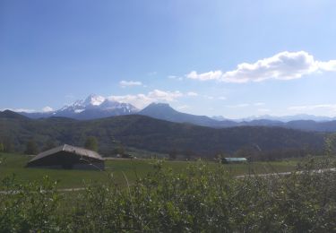
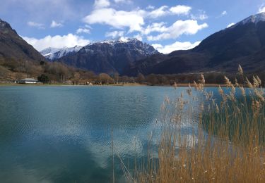
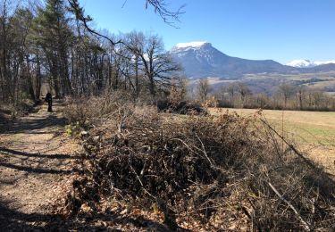
Boucle et en Aller/Retour sur la crête de la Sciau pour arriver à la Croix de la Roche et du Signal St-Michel afin de profiter de la vue sur l'Obiou et sur le Dévoluy avec la Montagne de Faraut et le Pic de Bure au fond avant de rebrousser chemin. L'itinéraire se suit sans problème et il est pour une bonne partie du temps est en couvert.
Plaatsbepaling
Opmerkingen
Wandeltochten in de omgeving
![Tocht Stappen Sainte-Luce - Côte Rouge - Photo](https://media.geolcdn.com/t/375/260/de862aa8-3a89-4016-889b-2ec83352f8c0.jpg&format=jpg&maxdim=2)
![Stappen Stappen](https://static1.geolcdn.com/sitytour/trail-icons/101.png)
Stappen
![](/images/other/stat-length.png)
![](https://static1.geolcdn.com/siteimages/upload/files/16400158638029165_repeat_loop_refresh_sync_direction_icon.png)
![Tocht Stappen Saint-Laurent-en-Beaumont - Valbonnais Canal Beaumont StLaurent - Photo](https://media.geolcdn.com/t/375/260/c4704b83-2e24-4742-b66e-bcb05b8bcf7e.jpg&format=jpg&maxdim=2)
![Stappen Stappen](https://static1.geolcdn.com/sitytour/trail-icons/101.png)
Stappen
![](/images/other/stat-length.png)
![](https://static1.geolcdn.com/siteimages/upload/files/16400158638029165_repeat_loop_refresh_sync_direction_icon.png)
![Tocht Stappen Valbonnais - le canal du Beaumont ,les verneys - Photo](https://media.geolcdn.com/t/375/260/2798c172-0fea-462e-b7e1-5b2ec3854f74.jpg&format=jpg&maxdim=2)
![Stappen Stappen](https://static1.geolcdn.com/sitytour/trail-icons/101.png)
Stappen
![](/images/other/stat-length.png)
![](https://static1.geolcdn.com/siteimages/upload/files/16400158638029165_repeat_loop_refresh_sync_direction_icon.png)
![Tocht Elektrische fiets Saint-Laurent-en-Beaumont - plafin oris la valette retour pont roizon sievoz - Photo](https://media.geolcdn.com/t/375/260/c30c76dc-6911-42ed-b8ef-ed9754d00933.jpg&format=jpg&maxdim=2)
![Elektrische fiets Elektrische fiets](https://static1.geolcdn.com/sitytour/trail-icons/205.png)
Elektrische fiets
![](/images/other/stat-length.png)
![](https://static1.geolcdn.com/siteimages/upload/files/16400158638029165_repeat_loop_refresh_sync_direction_icon.png)
![Tocht Mountainbike Sainte-Luce - St luce canal beaumont - Photo](https://media.geolcdn.com/t/375/260/60142226-66a3-460c-8141-c2be117708e1.jpg&format=jpg&maxdim=2)
![Mountainbike Mountainbike](https://static1.geolcdn.com/sitytour/trail-icons/202.png)
Mountainbike
![](/images/other/stat-length.png)
![](https://static1.geolcdn.com/siteimages/upload/files/16400158638029165_repeat_loop_refresh_sync_direction_icon.png)
![Tocht Stappen Valbonnais - Tour de Belle Roche - Photo](https://media.geolcdn.com/t/375/260/91066cd2-60eb-4718-9a52-c7ed0cc960b6.jpg&format=jpg&maxdim=2)
![Stappen Stappen](https://static1.geolcdn.com/sitytour/trail-icons/101.png)
Stappen
![](/images/other/stat-length.png)
![](https://static1.geolcdn.com/siteimages/upload/files/16400158638029165_repeat_loop_refresh_sync_direction_icon.png)
![Tocht Stappen Siévoz - foison 2019 - Photo](https://media.geolcdn.com/t/375/260/537d50cf-b64a-4f53-8391-3ea482796d94.jpg&format=jpg&maxdim=2)
![Stappen Stappen](https://static1.geolcdn.com/sitytour/trail-icons/101.png)
Stappen
![](/images/other/stat-length.png)
![](https://static1.geolcdn.com/siteimages/upload/files/16400158638029165_repeat_loop_refresh_sync_direction_icon.png)
![Tocht Stappen Valbonnais - Plan d'eau de Valbonnais - Les Angelas - Photo](https://media.geolcdn.com/t/375/260/9ae4a389-9dd0-471c-a080-0d4fd731465e.jpg&format=jpg&maxdim=2)
![Stappen Stappen](https://static1.geolcdn.com/sitytour/trail-icons/101.png)
Stappen
![](/images/other/stat-length.png)
![](https://static1.geolcdn.com/siteimages/upload/files/16400158638029165_repeat_loop_refresh_sync_direction_icon.png)
![Tocht Stappen Saint-Laurent-en-Beaumont - Tour du canal de Beaumont - Photo](https://media.geolcdn.com/t/375/260/ext.jpg?maxdim=2&url=https%3A%2F%2Fservices.sitytrail.com%2FGeolivesWS%2FDownloadMedia.ashx%3FTrailID%3D1126212%26Media%3D20190324104750.jpg)
![Stappen Stappen](https://static1.geolcdn.com/sitytour/trail-icons/101.png)
Stappen
![](/images/other/stat-length.png)
![](https://static1.geolcdn.com/siteimages/upload/files/16400158638029165_repeat_loop_refresh_sync_direction_icon.png)