![](/images/other/stat-length.png)
![Tocht Te voet Lindry - Les houches Lindry CHARBUY - Photo](https://media.geolcdn.com/t/1900/400/ext.pjpeg?maxdim=2&url=https%3A%2F%2Fstatic1.geolcdn.com%2Fsiteimages%2Fupload%2Ffiles%2F1545311037marcheuse_200dpi.jpg)
Les houches Lindry CHARBUY
JMC89
Gebruiker
![Lengte](/images/other/stat-length.png)
Lengte
8,1 km
![Max. hoogte](https://static1.geolcdn.com/siteimages/upload/files/1508320355ic_sort_altitude_max_24dp.png)
Max. hoogte
195 m
![Positief hoogteverschil](https://static1.geolcdn.com/siteimages/upload/files/1508320355ic_sort_den_pos_24dp.png)
Positief hoogteverschil
100 m
![Km-Effort](/images/other/stat-length.png)
Km-Effort
9,4 km
![Min. hoogte](https://static1.geolcdn.com/siteimages/upload/files/1508320355ic_sort_altitude_min_24dp.png)
Min. hoogte
149 m
![Negatief hoogteverschil](https://static1.geolcdn.com/siteimages/upload/files/1508320355ic_sort_den_neg_24dp.png)
Negatief hoogteverschil
100 m
![Boucle](https://static1.geolcdn.com/siteimages/upload/files/16400158638029165_repeat_loop_refresh_sync_direction_icon.png)
Boucle
Ja
Datum van aanmaak :
2023-06-19 14:52:28.668
Laatste wijziging :
2023-06-19 15:45:36.429
![Te voet](https://static1.geolcdn.com/sitytour/trail-icons/100.png)
2h08
Moeilijkheid : Gemakkelijk
![Scan deze QR-code om de tocht te openen in de SityTrail-applicatie](https://capi.geolives.com/qq0zvz2zws4bq2lad0pu/sitytour/trails/3705152/qr.png?size=200)
Gratisgps-wandelapplicatie
Over ons
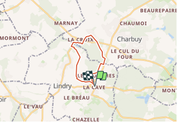
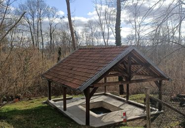
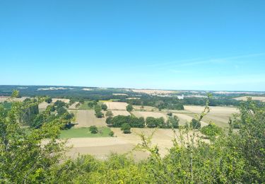
Tocht Te voet van 8,1 km beschikbaar op Bourgondië-Franche-Comté, Yonne, Lindry. Deze tocht wordt voorgesteld door JMC89.
Beschrijving
Départ du lieudit la Cave (Commune de Lindry ) en direction de du Marais et remontée vers le Chateau Gaillard puis empruntez le GR 13 jusqu'à Vieux Champs redescendez sur les Houches via la fôret
Plaatsbepaling
Land:
France
Regio :
Bourgondië-Franche-Comté
Departement/Provincie :
Yonne
Gemeente :
Lindry
Locatie:
Unknown
Vertrek:(Dec)
Vertrek:(UTM)
533103 ; 5294179 (31T) N.
Opmerkingen
Wandeltochten in de omgeving
![Tocht Stappen Villefargeau - Boucle de 11 km à Villefargeau 89240 - Photo](https://media.geolcdn.com/t/375/260/faa13327-70c0-40d4-aef2-0c2d4c7ad3e6.jpg&format=jpg&maxdim=2)
![Stappen Stappen](https://static1.geolcdn.com/sitytour/trail-icons/101.png)
Boucle de 11 km à Villefargeau 89240
Stappen
Gemakkelijk
Villefargeau,
Bourgondië-Franche-Comté,
Yonne,
France
![](/images/other/stat-length.png)
11,1 km | 12,6 km-effort
2h 0min
![](https://static1.geolcdn.com/siteimages/upload/files/16400158638029165_repeat_loop_refresh_sync_direction_icon.png)
Ja
![Tocht Stappen Villefargeau - Boucle des 3 Fontaines - Photo](https://media.geolcdn.com/t/375/260/ecb003da-b7b9-4c25-b892-dae8e611b82c.jpg&format=jpg&maxdim=2)
![Stappen Stappen](https://static1.geolcdn.com/sitytour/trail-icons/101.png)
Boucle des 3 Fontaines
Stappen
Gemakkelijk
Villefargeau,
Bourgondië-Franche-Comté,
Yonne,
France
![](/images/other/stat-length.png)
6,9 km | 8,1 km-effort
47min
![](https://static1.geolcdn.com/siteimages/upload/files/16400158638029165_repeat_loop_refresh_sync_direction_icon.png)
Ja
![Tocht Stappen Villefargeau - Boucle en marche rapide des 3 Fontaines 89 - Photo](https://media.geolcdn.com/t/375/260/2ee85ff9-7034-43bf-bef2-2e16eb90cf1d.jpg&format=jpg&maxdim=2)
![Stappen Stappen](https://static1.geolcdn.com/sitytour/trail-icons/101.png)
Boucle en marche rapide des 3 Fontaines 89
Stappen
Gemakkelijk
Villefargeau,
Bourgondië-Franche-Comté,
Yonne,
France
![](/images/other/stat-length.png)
7,5 km | 8,6 km-effort
1h 14min
![](https://static1.geolcdn.com/siteimages/upload/files/16400158638029165_repeat_loop_refresh_sync_direction_icon.png)
Ja
![Tocht Stappen Villefargeau - Rando Bois l'abbé et 3 Fontaines - Photo](https://media.geolcdn.com/t/375/260/232c466e-3014-433f-8498-9ab06ad7131b.jpg&format=jpg&maxdim=2)
![Stappen Stappen](https://static1.geolcdn.com/sitytour/trail-icons/101.png)
Rando Bois l'abbé et 3 Fontaines
Stappen
Gemakkelijk
Villefargeau,
Bourgondië-Franche-Comté,
Yonne,
France
![](/images/other/stat-length.png)
7,9 km | 9,5 km-effort
1h 31min
![](https://static1.geolcdn.com/siteimages/upload/files/16400158638029165_repeat_loop_refresh_sync_direction_icon.png)
Ja
![Tocht Stappen Branches - Branches aérodrome - Photo](https://media.geolcdn.com/t/375/260/c6145526-1c17-485f-a1a0-2ca178c16e00.jpg&format=jpg&maxdim=2)
![Stappen Stappen](https://static1.geolcdn.com/sitytour/trail-icons/101.png)
Branches aérodrome
Stappen
Heel gemakkelijk
(1)
Branches,
Bourgondië-Franche-Comté,
Yonne,
France
![](/images/other/stat-length.png)
6,3 km | 7,1 km-effort
1h 35min
![](https://static1.geolcdn.com/siteimages/upload/files/16400158638029165_repeat_loop_refresh_sync_direction_icon.png)
Ja
![Tocht Stappen Lindry - AVF LINDRY 06062023 - Photo](https://media.geolcdn.com/t/375/260/ed3f14ba-729b-4a26-9a4e-fad52440ab09.jpg&format=jpg&maxdim=2)
![Stappen Stappen](https://static1.geolcdn.com/sitytour/trail-icons/101.png)
AVF LINDRY 06062023
Stappen
Medium
Lindry,
Bourgondië-Franche-Comté,
Yonne,
France
![](/images/other/stat-length.png)
8,4 km | 10,3 km-effort
2h 1min
![](https://static1.geolcdn.com/siteimages/upload/files/16400158638029165_repeat_loop_refresh_sync_direction_icon.png)
Ja
![Tocht Stappen Charbuy - Rando Charbuy - Photo](https://media.geolcdn.com/t/375/260/ext.jpg?maxdim=2&url=https%3A%2F%2Fstatic1.geolcdn.com%2Fsiteimages%2Fupload%2Ffiles%2F1553511878bg_sport_marche.png)
![Stappen Stappen](https://static1.geolcdn.com/sitytour/trail-icons/101.png)
Rando Charbuy
Stappen
Medium
Charbuy,
Bourgondië-Franche-Comté,
Yonne,
France
![](/images/other/stat-length.png)
10,2 km | 11,8 km-effort
2h 32min
![](https://static1.geolcdn.com/siteimages/upload/files/16400158638029165_repeat_loop_refresh_sync_direction_icon.png)
Ja
![Tocht Stappen Charbuy - Charbuy - Auxerre - Photo](https://media.geolcdn.com/t/375/260/ext.jpg?maxdim=2&url=https%3A%2F%2Fstatic1.geolcdn.com%2Fsiteimages%2Fupload%2Ffiles%2F1553511878bg_sport_marche.png)
![Stappen Stappen](https://static1.geolcdn.com/sitytour/trail-icons/101.png)
Charbuy - Auxerre
Stappen
Gemakkelijk
Charbuy,
Bourgondië-Franche-Comté,
Yonne,
France
![](/images/other/stat-length.png)
9,5 km | 11,8 km-effort
23min
![](https://static1.geolcdn.com/siteimages/upload/files/16400158638029165_repeat_loop_refresh_sync_direction_icon.png)
Neen
![Tocht Mountainbike Égleny - l 'orchidée noire - Photo](https://media.geolcdn.com/t/375/260/ext.jpg?maxdim=2&url=https%3A%2F%2Fstatic1.geolcdn.com%2Fsiteimages%2Fupload%2Ffiles%2F1524743154velo.jpg)
![Mountainbike Mountainbike](https://static1.geolcdn.com/sitytour/trail-icons/202.png)
l 'orchidée noire
Mountainbike
Moeilijk
Égleny,
Bourgondië-Franche-Comté,
Yonne,
France
![](/images/other/stat-length.png)
11 km | 0 m-effort
1h 16min
![](https://static1.geolcdn.com/siteimages/upload/files/16400158638029165_repeat_loop_refresh_sync_direction_icon.png)
Ja