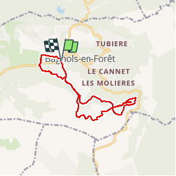
![](/images/other/stat-length.png)
![Tocht Stappen Bagnols-en-Forêt - Bagnols-Pic de la Gardiette Rando - Photo](https://media.geolcdn.com/t/1900/400/ext.pjpeg?maxdim=2&url=https%3A%2F%2Fservices.sitytrail.com%2FGeolivesWS%2FDownloadMedia.ashx%3FTrailID%3D369183%26Media%3Dfix__20141210150733.jpg)
Bagnols-Pic de la Gardiette Rando
Sugg
Gebruiker
![Lengte](/images/other/stat-length.png)
![Max. hoogte](https://static1.geolcdn.com/siteimages/upload/files/1508320355ic_sort_altitude_max_24dp.png)
![Positief hoogteverschil](https://static1.geolcdn.com/siteimages/upload/files/1508320355ic_sort_den_pos_24dp.png)
![Km-Effort](/images/other/stat-length.png)
![Min. hoogte](https://static1.geolcdn.com/siteimages/upload/files/1508320355ic_sort_altitude_min_24dp.png)
![Negatief hoogteverschil](https://static1.geolcdn.com/siteimages/upload/files/1508320355ic_sort_den_neg_24dp.png)
![Boucle](https://static1.geolcdn.com/siteimages/upload/files/16400158638029165_repeat_loop_refresh_sync_direction_icon.png)
![Stappen](https://static1.geolcdn.com/sitytour/trail-icons/101.png)
4h29
Moeilijkheid : Medium
![Scan deze QR-code om de tocht te openen in de SityTrail-applicatie](https://capi.geolives.com/qq0zvz2zws4bq2lad0pu/sitytour/trails/369183/qr.png?size=200)
Gratisgps-wandelapplicatie
Over ons
Tocht Stappen van 15 km beschikbaar op Provence-Alpes-Côte d'Azur, Var, Bagnols-en-Forêt. Deze tocht wordt voorgesteld door Sugg.
Beschrijving
10-12-14. Bagnols en Forêt
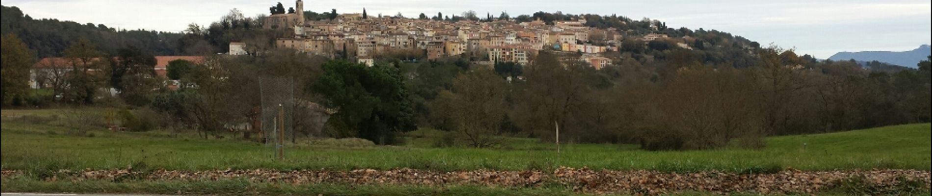
Rando à la journée de Restons en Forme, au départ de la chapelle Notre Dame de Pitié en passant par le col de la Pierre du Coucou, le Gr51, contournement du Petit Roc et du Pic par le Sud, montée au sommet et retour par la piste du petit Roc, au cimetière, prendre à l'Ouest pour contourner Valère et le plan Notre Dame.
Temps agréable vue dégagée. Pique-nique au sommet. The top.
Plaatsbepaling
Opmerkingen
Wandeltochten in de omgeving
![Tocht Stappen Le Muy - Pic du Castel Diaou - Fille d'Isnard - Pic Rébéquier - Photo](https://media.geolcdn.com/t/375/260/4f204571-7b19-40b2-95c4-b71e4d308f15.jpg&format=jpg&maxdim=2)
![Stappen Stappen](https://static1.geolcdn.com/sitytour/trail-icons/101.png)
Stappen
![](/images/other/stat-length.png)
![](https://static1.geolcdn.com/siteimages/upload/files/16400158638029165_repeat_loop_refresh_sync_direction_icon.png)
![Tocht Stappen Puget-sur-Argens - La Lieutenante Anc. Meulière Sce St Martin - Photo](https://media.geolcdn.com/t/375/260/f785d328-8629-4b96-81e2-754ca59456cd.jpg&format=jpg&maxdim=2)
![Stappen Stappen](https://static1.geolcdn.com/sitytour/trail-icons/101.png)
Stappen
![](/images/other/stat-length.png)
![](https://static1.geolcdn.com/siteimages/upload/files/16400158638029165_repeat_loop_refresh_sync_direction_icon.png)
![Tocht Mountainbike Puget-sur-Argens - Forêt de la Colle du Rouet aux Gorges de Blavet - Fréjus - Photo](https://media.geolcdn.com/t/375/260/ext.jpg?maxdim=2&url=https%3A%2F%2Fservices.sitytrail.com%2FGeolivesWS%2FDownloadMedia.ashx%3FTrailID%3D191635%26Media%3D15278_6.jpg)
![Mountainbike Mountainbike](https://static1.geolcdn.com/sitytour/trail-icons/202.png)
Mountainbike
![](/images/other/stat-length.png)
![](https://static1.geolcdn.com/siteimages/upload/files/16400158638029165_repeat_loop_refresh_sync_direction_icon.png)
![Tocht Stappen Bagnols-en-Forêt - La Colle du Rouet par le Castel Diaou - Le Muy - Photo](https://media.geolcdn.com/t/375/260/ext.jpg?maxdim=2&url=https%3A%2F%2Fservices.sitytrail.com%2FGeolivesWS%2FDownloadMedia.ashx%3FTrailID%3D191579%26Media%3D15205_3.jpg)
![Stappen Stappen](https://static1.geolcdn.com/sitytour/trail-icons/101.png)
Stappen
![](/images/other/stat-length.png)
![](https://static1.geolcdn.com/siteimages/upload/files/16400158638029165_repeat_loop_refresh_sync_direction_icon.png)
![Tocht Te voet Bagnols-en-Forêt - BAGNOLS EN FORET- Bois du défens DRI - Photo](https://media.geolcdn.com/t/375/260/ext.jpg?maxdim=2&url=https%3A%2F%2Fstatic1.geolcdn.com%2Fsiteimages%2Fupload%2Ffiles%2F1545311037marcheuse_200dpi.jpg)
![Te voet Te voet](https://static1.geolcdn.com/sitytour/trail-icons/100.png)
Te voet
![](/images/other/stat-length.png)
![](https://static1.geolcdn.com/siteimages/upload/files/16400158638029165_repeat_loop_refresh_sync_direction_icon.png)
![Tocht Stappen Bagnols-en-Forêt - Gorges du Blavet au col de la pierre du coucou - Photo](https://media.geolcdn.com/t/375/260/09e580ef-d921-4dee-80f6-a698afe27096.jpg&format=jpg&maxdim=2)
![Stappen Stappen](https://static1.geolcdn.com/sitytour/trail-icons/101.png)
Stappen
![](/images/other/stat-length.png)
![](https://static1.geolcdn.com/siteimages/upload/files/16400158638029165_repeat_loop_refresh_sync_direction_icon.png)
![Tocht sport Bagnols-en-Forêt - Lac Rioutard Bagnols en forêt - Photo](https://media.geolcdn.com/t/375/260/0154e3c4-4912-418f-af0f-e920b58b6bc0.jpg&format=jpg&maxdim=2)
sport
![](/images/other/stat-length.png)
![](https://static1.geolcdn.com/siteimages/upload/files/16400158638029165_repeat_loop_refresh_sync_direction_icon.png)
![Tocht sport Bagnols-en-Forêt - Gorges de Blavet pays de Fayence - Photo](https://media.geolcdn.com/t/375/260/752b007a-5919-43b0-bdb0-68a447f575ab.jpg&format=jpg&maxdim=2)
sport
![](/images/other/stat-length.png)
![](https://static1.geolcdn.com/siteimages/upload/files/16400158638029165_repeat_loop_refresh_sync_direction_icon.png)
![Tocht sport Bagnols-en-Forêt - Bagnols en Forêt les meules - Photo](https://media.geolcdn.com/t/375/260/4bb66a92-f34f-4592-9bb4-da4e654f5bf9.jpg&format=jpg&maxdim=2)
sport
![](/images/other/stat-length.png)
![](https://static1.geolcdn.com/siteimages/upload/files/16400158638029165_repeat_loop_refresh_sync_direction_icon.png)