![](/images/other/stat-length.png)
![Tocht Stappen Ranrupt - 2023-06-04 Marche Col de Steige Tour du Climont - Photo](https://media.geolcdn.com/t/1900/400/935b7e44-7265-42c7-b6c2-a8897e52a122.jpg&format=pjpeg&maxdim=2)
2023-06-04 Marche Col de Steige Tour du Climont
holtzv
Gebruiker GUIDE
![Lengte](/images/other/stat-length.png)
Lengte
14,5 km
![Max. hoogte](https://static1.geolcdn.com/siteimages/upload/files/1508320355ic_sort_altitude_max_24dp.png)
Max. hoogte
964 m
![Positief hoogteverschil](https://static1.geolcdn.com/siteimages/upload/files/1508320355ic_sort_den_pos_24dp.png)
Positief hoogteverschil
715 m
![Km-Effort](/images/other/stat-length.png)
Km-Effort
24 km
![Min. hoogte](https://static1.geolcdn.com/siteimages/upload/files/1508320355ic_sort_altitude_min_24dp.png)
Min. hoogte
374 m
![Negatief hoogteverschil](https://static1.geolcdn.com/siteimages/upload/files/1508320355ic_sort_den_neg_24dp.png)
Negatief hoogteverschil
716 m
![Boucle](https://static1.geolcdn.com/siteimages/upload/files/16400158638029165_repeat_loop_refresh_sync_direction_icon.png)
Boucle
Ja
Datum van aanmaak :
2023-06-04 08:51:26.915
Laatste wijziging :
2023-06-04 15:51:36.824
![Stappen](https://static1.geolcdn.com/sitytour/trail-icons/101.png)
5h28
Moeilijkheid : Gemakkelijk
![Scan deze QR-code om de tocht te openen in de SityTrail-applicatie](https://capi.geolives.com/qq0zvz2zws4bq2lad0pu/sitytour/trails/3687101/qr.png?size=200)
Gratisgps-wandelapplicatie
Over ons
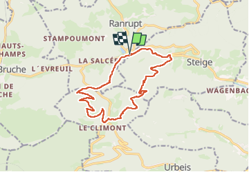
Tocht Stappen van 14,5 km beschikbaar op Grand Est, Bas-Rhin, Ranrupt. Deze tocht wordt voorgesteld door holtzv.
Beschrijving
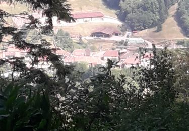
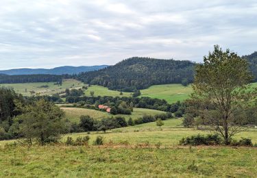
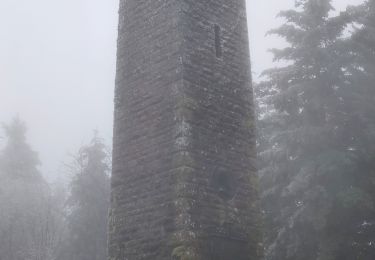
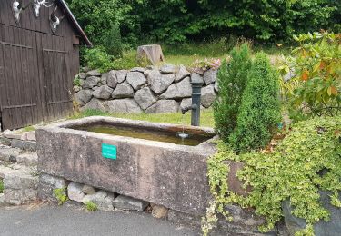
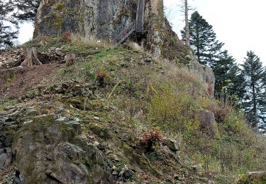
Boucle depuis le col de steige en passant par la tour du Climont (tour Julius), le grand sapin (coupé depuis 1958), cabane de la Hâle et le Mont
Plaatsbepaling
Land:
France
Regio :
Grand Est
Departement/Provincie :
Bas-Rhin
Gemeente :
Ranrupt
Locatie:
Unknown
Vertrek:(Dec)
Vertrek:(UTM)
366725 ; 5358269 (32U) N.
Opmerkingen
Wandeltochten in de omgeving
![Tocht Stappen Steige - Steige blanc - Photo](https://media.geolcdn.com/t/375/260/3138d5a8-8f43-46fd-9a0c-b8aa1ff2972d.jpg&format=jpg&maxdim=2)
![Stappen Stappen](https://static1.geolcdn.com/sitytour/trail-icons/101.png)
Steige blanc
Stappen
Medium
(1)
Steige,
Grand Est,
Bas-Rhin,
France
![](/images/other/stat-length.png)
7,8 km | 12,6 km-effort
2h 7min
![](https://static1.geolcdn.com/siteimages/upload/files/16400158638029165_repeat_loop_refresh_sync_direction_icon.png)
Ja
![Tocht Paardrijden Bourg-Bruche - 2023-09-16 Picnic CVA Climont Bourg Bruche - Photo](https://media.geolcdn.com/t/375/260/e3b3477a-361e-4f3c-9903-89043f8145ea.jpg&format=jpg&maxdim=2)
![Paardrijden Paardrijden](https://static1.geolcdn.com/sitytour/trail-icons/301.png)
2023-09-16 Picnic CVA Climont Bourg Bruche
Paardrijden
Medium
Bourg-Bruche,
Grand Est,
Bas-Rhin,
France
![](/images/other/stat-length.png)
27 km | 39 km-effort
5h 11min
![](https://static1.geolcdn.com/siteimages/upload/files/16400158638029165_repeat_loop_refresh_sync_direction_icon.png)
Ja
![Tocht Stappen Ranrupt - 2018-12-30 Marche Climont Voyemont - Photo](https://media.geolcdn.com/t/375/260/55e3f2c1-2c0e-4070-b418-3c553de20538.jpg&format=jpg&maxdim=2)
![Stappen Stappen](https://static1.geolcdn.com/sitytour/trail-icons/101.png)
2018-12-30 Marche Climont Voyemont
Stappen
Heel gemakkelijk
Ranrupt,
Grand Est,
Bas-Rhin,
France
![](/images/other/stat-length.png)
22 km | 33 km-effort
7h 21min
![](https://static1.geolcdn.com/siteimages/upload/files/16400158638029165_repeat_loop_refresh_sync_direction_icon.png)
Ja
![Tocht Paardrijden Belmont - Circuit VC Serva - Le Climont - Photo](https://media.geolcdn.com/t/375/260/a1198139-b874-4847-adb3-efd42fb36195.jpg&format=jpg&maxdim=2)
![Paardrijden Paardrijden](https://static1.geolcdn.com/sitytour/trail-icons/301.png)
Circuit VC Serva - Le Climont
Paardrijden
Medium
Belmont,
Grand Est,
Bas-Rhin,
France
![](/images/other/stat-length.png)
23 km | 33 km-effort
4h 20min
![](https://static1.geolcdn.com/siteimages/upload/files/16400158638029165_repeat_loop_refresh_sync_direction_icon.png)
Neen
![Tocht Paardrijden Belmont - Circuit VC Le Hohwald - Serva - Photo](https://media.geolcdn.com/t/375/260/1588be67-92f1-44c9-a365-dcd95e3feb13.jpg&format=jpg&maxdim=2)
![Paardrijden Paardrijden](https://static1.geolcdn.com/sitytour/trail-icons/301.png)
Circuit VC Le Hohwald - Serva
Paardrijden
Medium
Belmont,
Grand Est,
Bas-Rhin,
France
![](/images/other/stat-length.png)
16,2 km | 22 km-effort
2h 50min
![](https://static1.geolcdn.com/siteimages/upload/files/16400158638029165_repeat_loop_refresh_sync_direction_icon.png)
Neen
![Tocht Stappen Bellefosse - Col de la Charbonnière - château de la Roche - Bellefosse - Belmont - Photo](https://media.geolcdn.com/t/375/260/24310c6f-c7f0-4534-8ba0-5207981b0c8c.jpg&format=jpg&maxdim=2)
![Stappen Stappen](https://static1.geolcdn.com/sitytour/trail-icons/101.png)
Col de la Charbonnière - château de la Roche - Bellefosse - Belmont
Stappen
Zeer moeilijk
Bellefosse,
Grand Est,
Bas-Rhin,
France
![](/images/other/stat-length.png)
15,7 km | 24 km-effort
5h 27min
![](https://static1.geolcdn.com/siteimages/upload/files/16400158638029165_repeat_loop_refresh_sync_direction_icon.png)
Ja
![Tocht Sneeuwschoenen Belmont - cascade de la serva - Photo](https://media.geolcdn.com/t/375/260/9e54cbbc-1369-400d-91a3-b8884cb0f35c.jpg&format=jpg&maxdim=2)
![Sneeuwschoenen Sneeuwschoenen](https://static1.geolcdn.com/sitytour/trail-icons/504.png)
cascade de la serva
Sneeuwschoenen
Medium
Belmont,
Grand Est,
Bas-Rhin,
France
![](/images/other/stat-length.png)
7,1 km | 10,8 km-effort
3h 41min
![](https://static1.geolcdn.com/siteimages/upload/files/16400158638029165_repeat_loop_refresh_sync_direction_icon.png)
Ja
![Tocht Stappen Breitenbach - Col de la Charbonnière -Château de la Roche - Photo](https://media.geolcdn.com/t/375/260/2697d717-0d30-43cc-9812-47c6d2c21947.jpg&format=jpg&maxdim=2)
![Stappen Stappen](https://static1.geolcdn.com/sitytour/trail-icons/101.png)
Col de la Charbonnière -Château de la Roche
Stappen
Medium
Breitenbach,
Grand Est,
Bas-Rhin,
France
![](/images/other/stat-length.png)
16,2 km | 24 km-effort
4h 20min
![](https://static1.geolcdn.com/siteimages/upload/files/16400158638029165_repeat_loop_refresh_sync_direction_icon.png)
Ja
![Tocht Stappen Belmont - Tour du Champ du Feu - Photo](https://media.geolcdn.com/t/375/260/fa28d30d-9229-4759-b386-8c9b339ab424.jpg&format=jpg&maxdim=2)
![Stappen Stappen](https://static1.geolcdn.com/sitytour/trail-icons/101.png)
Tour du Champ du Feu
Stappen
Gemakkelijk
Belmont,
Grand Est,
Bas-Rhin,
France
![](/images/other/stat-length.png)
10,9 km | 15,1 km-effort
2h 57min
![](https://static1.geolcdn.com/siteimages/upload/files/16400158638029165_repeat_loop_refresh_sync_direction_icon.png)
Ja