![](/images/other/stat-length.png)
![Tocht Stappen Annecy - 260523 Monr Veyrier - Photo](https://media.geolcdn.com/t/1900/400/7cafe482-fdd0-430f-9583-efd1a36c0573.jpg&format=pjpeg&maxdim=2)
260523 Monr Veyrier
mzonzon05
Gebruiker
![Lengte](/images/other/stat-length.png)
![Max. hoogte](https://static1.geolcdn.com/siteimages/upload/files/1508320355ic_sort_altitude_max_24dp.png)
![Positief hoogteverschil](https://static1.geolcdn.com/siteimages/upload/files/1508320355ic_sort_den_pos_24dp.png)
![Km-Effort](/images/other/stat-length.png)
![Min. hoogte](https://static1.geolcdn.com/siteimages/upload/files/1508320355ic_sort_altitude_min_24dp.png)
![Negatief hoogteverschil](https://static1.geolcdn.com/siteimages/upload/files/1508320355ic_sort_den_neg_24dp.png)
![Boucle](https://static1.geolcdn.com/siteimages/upload/files/16400158638029165_repeat_loop_refresh_sync_direction_icon.png)
![Stappen](https://static1.geolcdn.com/sitytour/trail-icons/101.png)
4h24
Moeilijkheid : Moeilijk
![Scan deze QR-code om de tocht te openen in de SityTrail-applicatie](https://capi.geolives.com/qq0zvz2zws4bq2lad0pu/sitytour/trails/3675313/qr.png?size=200)
Gratisgps-wandelapplicatie
Over ons
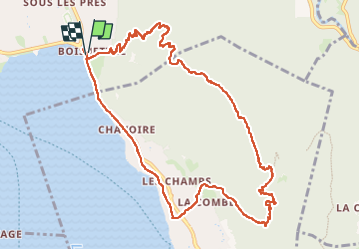
Tocht Stappen van 12,6 km beschikbaar op Auvergne-Rhône-Alpes, Haute-Savoie, Annecy. Deze tocht wordt voorgesteld door mzonzon05.
Beschrijving
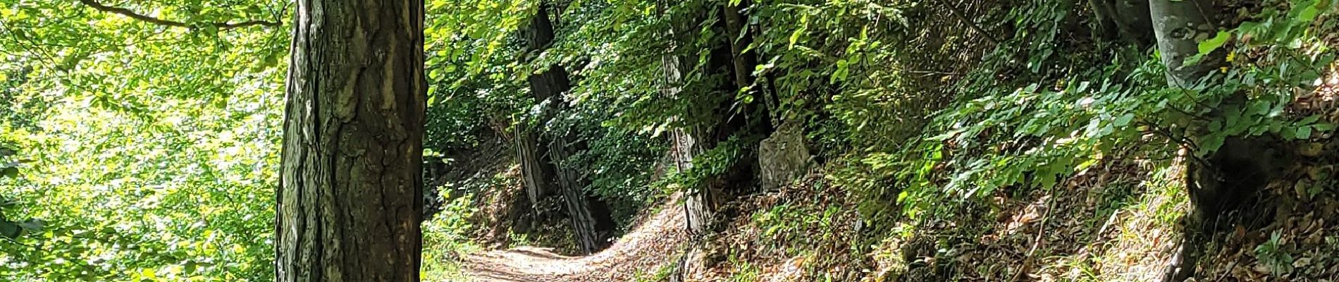
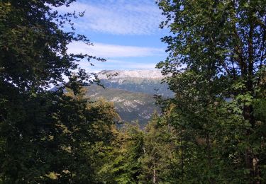
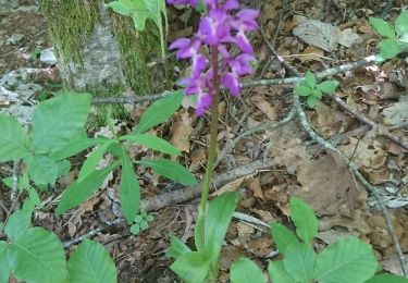
une balade pas facile car ça monte sec puis la redescende nous réconcilie avec nos pieds car elle se fait globalement sur un tapis de feuilles ! Les points de vue sont spectaculaires et le lac et les Bauges à portée de main !
Bien sûr on n'est pas tout seul et toutes les langues sont au RDV, mais tout le monde semble content d'être là.
Plaatsbepaling
Opmerkingen
Wandeltochten in de omgeving
![Tocht Stappen Veyrier-du-Lac - 74 Mt Veyrier 26.06.23 - Photo](https://media.geolcdn.com/t/375/260/e7069dc2-0437-4294-a5ae-f7942e994b91.jpg&format=jpg&maxdim=2)
![Stappen Stappen](https://static1.geolcdn.com/sitytour/trail-icons/101.png)
Stappen
![](/images/other/stat-length.png)
![](https://static1.geolcdn.com/siteimages/upload/files/16400158638029165_repeat_loop_refresh_sync_direction_icon.png)
![Tocht Mountainbike Annecy - semnoz 31 8 10 - Photo](https://media.geolcdn.com/t/375/260/ext.jpg?maxdim=2&url=https%3A%2F%2Fstatic1.geolcdn.com%2Fsiteimages%2Fupload%2Ffiles%2F1524743154velo.jpg)
![Mountainbike Mountainbike](https://static1.geolcdn.com/sitytour/trail-icons/202.png)
Mountainbike
![](/images/other/stat-length.png)
![](https://static1.geolcdn.com/siteimages/upload/files/16400158638029165_repeat_loop_refresh_sync_direction_icon.png)
![Tocht Hybride fiets Annecy - ANNECY ... le Tour du lac à vélo. - Photo](https://media.geolcdn.com/t/375/260/64c38e9e-432d-4f1e-a098-d3a526529324.jpg&format=jpg&maxdim=2)
![Hybride fiets Hybride fiets](https://static1.geolcdn.com/sitytour/trail-icons/203.png)
Hybride fiets
![](/images/other/stat-length.png)
![](https://static1.geolcdn.com/siteimages/upload/files/16400158638029165_repeat_loop_refresh_sync_direction_icon.png)
![Tocht Stappen Annecy - ANNECY ... le sentier des crêtes. - Photo](https://media.geolcdn.com/t/375/260/954e85ce-e790-4ec1-8a5b-52762288e410.jpg&format=jpg&maxdim=2)
![Stappen Stappen](https://static1.geolcdn.com/sitytour/trail-icons/101.png)
Stappen
![](/images/other/stat-length.png)
![](https://static1.geolcdn.com/siteimages/upload/files/16400158638029165_repeat_loop_refresh_sync_direction_icon.png)
![Tocht Stappen Annecy - course avec tobias - Photo](https://media.geolcdn.com/t/375/260/5511a080-8bbf-4e35-a1e7-eb6c019b0144.jpg&format=jpg&maxdim=2)
![Stappen Stappen](https://static1.geolcdn.com/sitytour/trail-icons/101.png)
Stappen
![](/images/other/stat-length.png)
![](https://static1.geolcdn.com/siteimages/upload/files/16400158638029165_repeat_loop_refresh_sync_direction_icon.png)
![Tocht Fietstoerisme Veyrier-du-Lac - tour du lac d annecy - Photo](https://media.geolcdn.com/t/375/260/c737b45c-84b1-41e1-b4e0-10680cc8a9ed.jpg&format=jpg&maxdim=2)
![Fietstoerisme Fietstoerisme](https://static1.geolcdn.com/sitytour/trail-icons/204.png)
Fietstoerisme
![](/images/other/stat-length.png)
![](https://static1.geolcdn.com/siteimages/upload/files/16400158638029165_repeat_loop_refresh_sync_direction_icon.png)
![Tocht Stappen Veyrier-du-Lac - Mont Baret - Photo](https://media.geolcdn.com/t/375/260/204f4d77-91e4-44cb-b334-ef87d103e733.jpg&format=jpg&maxdim=2)
![Stappen Stappen](https://static1.geolcdn.com/sitytour/trail-icons/101.png)
Stappen
![](/images/other/stat-length.png)
![](https://static1.geolcdn.com/siteimages/upload/files/16400158638029165_repeat_loop_refresh_sync_direction_icon.png)
![Tocht Stappen Annecy - Belvédère mont Baron - Photo](https://media.geolcdn.com/t/375/260/9f969196-bc81-4eef-b145-80c017b0d1a2.jpg&format=jpg&maxdim=2)
![Stappen Stappen](https://static1.geolcdn.com/sitytour/trail-icons/101.png)
Stappen
![](/images/other/stat-length.png)
![](https://static1.geolcdn.com/siteimages/upload/files/16400158638029165_repeat_loop_refresh_sync_direction_icon.png)
![Tocht Stappen Veyrier-du-Lac - tour du veyrier - Photo](https://media.geolcdn.com/t/375/260/a4b66537-c6f9-4733-a7d4-3e4490b849c0.jpg&format=jpg&maxdim=2)
![Stappen Stappen](https://static1.geolcdn.com/sitytour/trail-icons/101.png)
Stappen
![](/images/other/stat-length.png)
![](https://static1.geolcdn.com/siteimages/upload/files/16400158638029165_repeat_loop_refresh_sync_direction_icon.png)