Tocht Auto The Municipal District of Cahir — Cashel - j2-04 - Photo
 DUPORT16
DUPORT16

Gebruiker

© OpenStreetMap contributors
Lengte
Lengte
141 km
Max. hoogte
Max. hoogte
164 m
Positief hoogteverschil
1043 m
Km-Effort
Km-Effort  
155 km
Min. hoogte
Min. hoogte
36 m
Negatief hoogteverschil
1112 m
Boucle
Boucle
Neen
Datum van aanmaak :
2023-05-24 14:36:30.327
Laatste wijziging :
2023-05-24 17:08:27.856

(0 Bericht)

Auto
Auto
2h31
Moeilijkheid : Heel gemakkelijk

Scan deze QR-code om de tocht te openen in de SityTrail-applicatie

Gratisgps-wandelapplicatie

Logo SityTrail SityTrail

IGN / Geografische instituten

SityTrail uit de App Store downloaden SityTrail uit Google Play downloaden

Logo SityTrail SityTrail World

De wereld gaat voor u open

SityTrail uit de App Store downloaden SityTrail uit Google Play downloaden SityTrail op Huawei AppGallery downloaden

Over ons

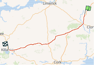
Tocht Auto van 141 km beschikbaar op Onbekend, County Tipperary, The Municipal District of Cahir — Cashel. Deze tocht wordt voorgesteld door DUPORT16.

Hoogteprofiel

Plaatsbepaling

Land:
Ireland
Regio :
Onbekend
Departement/Provincie :
County Tipperary
Gemeente :
The Municipal District of Cahir — Cashel
Locatie:
Cashel Rural
Vertrek:(UTM)
575408 ; 5819480 (29U) N.

Wandeltochten in de omgeving

Tocht Stappen The Municipal District of Cahir — Cashel - Cahir Scaragh Wood Trail 2 - Photo
Stappen
johnkeating

Stappen

Heel gemakkelijk
The Municipal District of Cahir — Cashel, Onbekend, County Tipperary, Ireland
5,5 km | 7,4 km-effort
1h 15min
Ja
Tocht Stappen The Municipal District of Cahir — Cashel - Cahir Scaragh Wood Trail 1 - Photo
Stappen
johnkeating

Stappen

Heel gemakkelijk
The Municipal District of Cahir — Cashel, Onbekend, County Tipperary, Ireland
4,6 km | 5,9 km-effort
1h 0min
Ja
Tocht Stappen The Municipal District of Cahir — Cashel - Cahir Scaragh Wood Trail 3 - Photo
Stappen
johnkeating

Stappen

Heel gemakkelijk
The Municipal District of Cahir — Cashel, Onbekend, County Tipperary, Ireland
6,4 km | 9,4 km-effort
1h 35min
Ja
Tocht Stappen The Municipal District of Cahir — Cashel - Galtees - Lake Muskry Circuit - Photo
Stappen
johnkeating

Stappen

Heel gemakkelijk
The Municipal District of Cahir — Cashel, Onbekend, County Tipperary, Ireland
10,1 km | 18,2 km-effort
3h 10min
Neen
Tocht Lopen The Municipal District of Cahir — Cashel - Bianconi Loop - Photo
Lopen
mlmoroneybb

Lopen

Gemakkelijk
The Municipal District of Cahir — Cashel, Onbekend, County Tipperary, Ireland
3,8 km | 5,3 km-effort
2h 0min
Ja
Tocht Lopen The Municipal District of Cahir — Cashel - Ballinacourty Loop - Photo
Lopen
mlmoroneybb

Lopen

Medium
The Municipal District of Cahir — Cashel, Onbekend, County Tipperary, Ireland
8,2 km | 10,9 km-effort
2h 0min
Ja
Tocht Lopen The Municipal District of Cahir — Cashel - The Millenium Stone Loop - Photo
Lopen
mlmoroneybb

Lopen

Medium
The Municipal District of Cahir — Cashel, Onbekend, County Tipperary, Ireland
9,4 km | 12,4 km-effort
2h 0min
Ja
Tocht Stappen The Municipal District of Cahir — Cashel - Slievenamuck Walking Marathon Sunday March 24th 2013 - Photo
Stappen
mlmoroneybb

Stappen

Moeilijk
The Municipal District of Cahir — Cashel, Onbekend, County Tipperary, Ireland
42 km | 56 km-effort
11h 36min
Neen
Tocht Stappen The Municipal District of Cahir — Cashel - Galtee Walking Club Marathon - Photo
Stappen
mlmoroneybb

Stappen

Moeilijk
The Municipal District of Cahir — Cashel, Onbekend, County Tipperary, Ireland
41 km | 54 km-effort
11h 22min
Ja


Sluiten
Mijn abonnementen