![](/images/other/stat-length.png)
![Tocht Stappen Monthodon - Monthodon Le Sentier - Photo](https://media.geolcdn.com/t/1900/400/86376099-ac84-49f8-82e1-db4414073e78.jpg&format=pjpeg&maxdim=2)
Monthodon Le Sentier
guydu41
Gebruiker
![Lengte](/images/other/stat-length.png)
![Max. hoogte](https://static1.geolcdn.com/siteimages/upload/files/1508320355ic_sort_altitude_max_24dp.png)
![Positief hoogteverschil](https://static1.geolcdn.com/siteimages/upload/files/1508320355ic_sort_den_pos_24dp.png)
![Km-Effort](/images/other/stat-length.png)
![Min. hoogte](https://static1.geolcdn.com/siteimages/upload/files/1508320355ic_sort_altitude_min_24dp.png)
![Negatief hoogteverschil](https://static1.geolcdn.com/siteimages/upload/files/1508320355ic_sort_den_neg_24dp.png)
![Boucle](https://static1.geolcdn.com/siteimages/upload/files/16400158638029165_repeat_loop_refresh_sync_direction_icon.png)
![Stappen](https://static1.geolcdn.com/sitytour/trail-icons/101.png)
2h09
Moeilijkheid : Medium
![Scan deze QR-code om de tocht te openen in de SityTrail-applicatie](https://capi.geolives.com/qq0zvz2zws4bq2lad0pu/sitytour/trails/3661655/qr.png?size=200)
Gratisgps-wandelapplicatie
Over ons
Tocht Stappen van 8,5 km beschikbaar op Centre-Val de Loire, Indre-et-Loire, Monthodon. Deze tocht wordt voorgesteld door guydu41.
Beschrijving
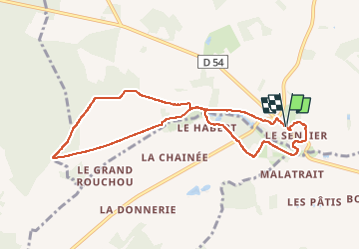
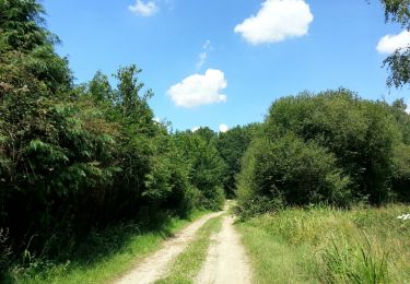
Ce circuit balisé jaune démarre depuis un petit parking Rue des Violettes (D54) au hameau de Monthodon - Le Sentier.
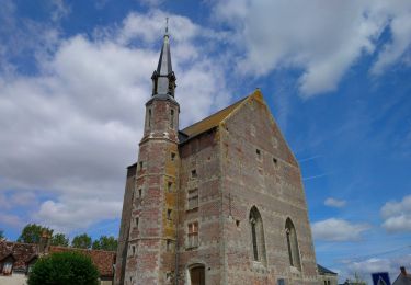
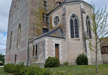
En face du parking on trouve un ancien Temple protestant construit en 1895 par la conversion massive de la population à ce culte.
Le parcours emprunte essentiellement des chemins au milieu des champs et au travers de petits bois.
Un détour dans le hameau permet d'admirer le lavoir dans lequel les habitantes venaient rincer leur linge.
Plaatsbepaling
Opmerkingen
Wandeltochten in de omgeving
![Tocht Stappen Saint-Laurent-en-Gâtines - Saint-Laurent-en-Gâtines - variante du PR Chemin de Chenusson - 10.2km 90m 2h25 - 2023 07 30 - Photo](https://media.geolcdn.com/t/375/260/9480277e-5582-454b-ba7d-ba1780556f7f.jpg&format=jpg&maxdim=2)
![Stappen Stappen](https://static1.geolcdn.com/sitytour/trail-icons/101.png)
Stappen
![](/images/other/stat-length.png)
![](https://static1.geolcdn.com/siteimages/upload/files/16400158638029165_repeat_loop_refresh_sync_direction_icon.png)
![Tocht Stappen - Monthodon - l'Aître Adam - 18.1km 140m 4h00 (35mn) - 2023 07 26 - Photo](https://media.geolcdn.com/t/375/260/3ad63fdb-ea8c-4f0a-920f-34c8d6a23e40.jpg&format=jpg&maxdim=2)
![Stappen Stappen](https://static1.geolcdn.com/sitytour/trail-icons/101.png)
Stappen
![](/images/other/stat-length.png)
![](https://static1.geolcdn.com/siteimages/upload/files/16400158638029165_repeat_loop_refresh_sync_direction_icon.png)
![Tocht Stappen Le Boulay - le Boulay - circuits Le pain sec et le Boulay avec variante le Sentier - 21.4km 180m 5h15 - 2022 05 05 - Photo](https://media.geolcdn.com/t/375/260/7bbdc975-98a0-4a8f-8bd9-b7c135231252.jpg&format=jpg&maxdim=2)
![Stappen Stappen](https://static1.geolcdn.com/sitytour/trail-icons/101.png)
Stappen
![](/images/other/stat-length.png)
![](https://static1.geolcdn.com/siteimages/upload/files/16400158638029165_repeat_loop_refresh_sync_direction_icon.png)
![Tocht Stappen Saint-Laurent-en-Gâtines - Saint-Laurent-en-Gâtines - Circuit jaune avec variante le Sentier - 18.7km 120m 4h30 - 2022 05 01 - Photo](https://media.geolcdn.com/t/375/260/8fa477e2-239d-46b3-938e-82d894cde1c1.jpg&format=jpg&maxdim=2)
![Stappen Stappen](https://static1.geolcdn.com/sitytour/trail-icons/101.png)
Stappen
![](/images/other/stat-length.png)
![](https://static1.geolcdn.com/siteimages/upload/files/16400158638029165_repeat_loop_refresh_sync_direction_icon.png)
![Tocht Stappen Monthodon - Monthodon - et Le Sentier - 26.7km 230m 6h00 - 2018 07 15 - public - Photo](https://media.geolcdn.com/t/375/260/ext.jpg?maxdim=2&url=https%3A%2F%2Fservices.sitytrail.com%2FGeolivesWS%2FDownloadMedia.ashx%3FTrailID%3D1004638%26Media%3Dfix__20180715141736.jpg)
![Stappen Stappen](https://static1.geolcdn.com/sitytour/trail-icons/101.png)
Stappen
![](/images/other/stat-length.png)
![](https://static1.geolcdn.com/siteimages/upload/files/16400158638029165_repeat_loop_refresh_sync_direction_icon.png)
![Tocht Stappen Saint-Laurent-en-Gâtines - Saint-Laurent-en-Gatines - Photo](https://media.geolcdn.com/t/375/260/3bcc51bc-dce3-484e-8c68-f9b9dd3f130d.jpg&format=jpg&maxdim=2)
![Stappen Stappen](https://static1.geolcdn.com/sitytour/trail-icons/101.png)
Stappen
![](/images/other/stat-length.png)
![](https://static1.geolcdn.com/siteimages/upload/files/16400158638029165_repeat_loop_refresh_sync_direction_icon.png)
![Tocht Stappen Le Boulay - le boulay sentier du pain sec - Photo](https://media.geolcdn.com/t/375/260/ext.jpg?maxdim=2&url=https%3A%2F%2Fservices.sitytrail.com%2FGeolivesWS%2FDownloadMedia.ashx%3FTrailID%3D307526%26Media%3Dfix__20140531104759.jpg)
![Stappen Stappen](https://static1.geolcdn.com/sitytour/trail-icons/101.png)
Stappen
![](/images/other/stat-length.png)
![](https://static1.geolcdn.com/siteimages/upload/files/16400158638029165_repeat_loop_refresh_sync_direction_icon.png)
![Tocht Stappen Saint-Laurent-en-Gâtines - saint laurent en gatine - Photo](https://media.geolcdn.com/t/375/260/ext.jpg?maxdim=2&url=https%3A%2F%2Fservices.sitytrail.com%2FGeolivesWS%2FDownloadMedia.ashx%3FTrailID%3D265906%26Media%3Dfix__20140412112239.jpg)
![Stappen Stappen](https://static1.geolcdn.com/sitytour/trail-icons/101.png)
Stappen
![](/images/other/stat-length.png)
![](https://static1.geolcdn.com/siteimages/upload/files/16400158638029165_repeat_loop_refresh_sync_direction_icon.png)
![Tocht Stappen Saint-Laurent-en-Gâtines - Saint Laurent en Gâtine 23, 5km - Photo](https://media.geolcdn.com/t/375/260/ext.jpg?maxdim=2&url=https%3A%2F%2Fstatic1.geolcdn.com%2Fsiteimages%2Fupload%2Ffiles%2F1553511878bg_sport_marche.png)
![Stappen Stappen](https://static1.geolcdn.com/sitytour/trail-icons/101.png)
Stappen
![](/images/other/stat-length.png)
![](https://static1.geolcdn.com/siteimages/upload/files/16400158638029165_repeat_loop_refresh_sync_direction_icon.png)