![](/images/other/stat-length.png)
![Tocht Stappen Le Diamant - O'Mullane bas vers la chérie en boucle. - Photo](https://media.geolcdn.com/t/1900/400/a195cd15-3add-4893-b6af-9a931553ed21.jpg&format=pjpeg&maxdim=2)
O'Mullane bas vers la chérie en boucle.
GabyG
Gebruiker GUIDE
![Lengte](/images/other/stat-length.png)
Lengte
4,9 km
![Max. hoogte](https://static1.geolcdn.com/siteimages/upload/files/1508320355ic_sort_altitude_max_24dp.png)
Max. hoogte
35 m
![Positief hoogteverschil](https://static1.geolcdn.com/siteimages/upload/files/1508320355ic_sort_den_pos_24dp.png)
Positief hoogteverschil
66 m
![Km-Effort](/images/other/stat-length.png)
Km-Effort
5,8 km
![Min. hoogte](https://static1.geolcdn.com/siteimages/upload/files/1508320355ic_sort_altitude_min_24dp.png)
Min. hoogte
0 m
![Negatief hoogteverschil](https://static1.geolcdn.com/siteimages/upload/files/1508320355ic_sort_den_neg_24dp.png)
Negatief hoogteverschil
66 m
![Boucle](https://static1.geolcdn.com/siteimages/upload/files/16400158638029165_repeat_loop_refresh_sync_direction_icon.png)
Boucle
Ja
Datum van aanmaak :
2023-05-14 13:42:09.399
Laatste wijziging :
2023-05-14 22:08:26.248
![Stappen](https://static1.geolcdn.com/sitytour/trail-icons/101.png)
2h00
Moeilijkheid : Medium
![Scan deze QR-code om de tocht te openen in de SityTrail-applicatie](https://capi.geolives.com/qq0zvz2zws4bq2lad0pu/sitytour/trails/3659351/qr.png?size=200)
Gratisgps-wandelapplicatie
Over ons
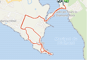
Tocht Stappen van 4,9 km beschikbaar op Martinique, Onbekend, Le Diamant. Deze tocht wordt voorgesteld door GabyG.
Beschrijving
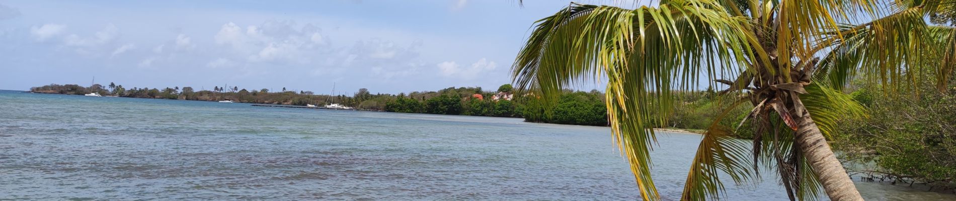
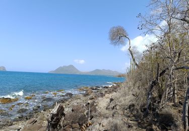
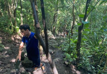
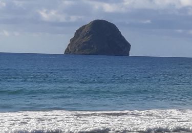
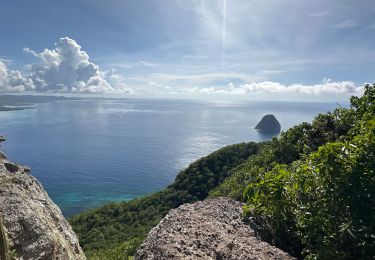
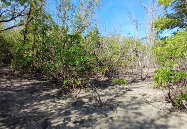
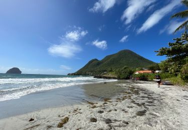
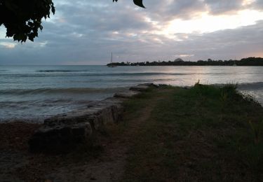
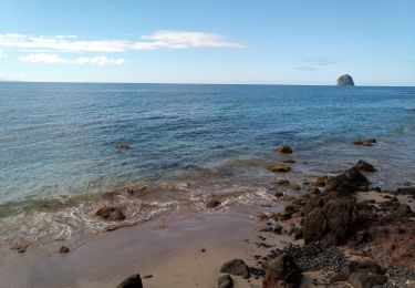
Belle randonnée sur le Diamant, depuis O'Mullane bas en passant par la mangrove, traversé de la rivière Fond Placide, le petit village de la chérie et les bordures côtières ! "Ex-Novotel"
plusieurs possibilités de bain s'offrent à nous quand la mer est belle.
Plaatsbepaling
Land:
France
Regio :
Martinique
Departement/Provincie :
Onbekend
Gemeente :
Le Diamant
Locatie:
Unknown
Vertrek:(Dec)
Vertrek:(UTM)
715144 ; 1601726 (20P) N.
Opmerkingen
Wandeltochten in de omgeving
![Tocht Stappen Le Diamant - le Diamant de Taupinière vers O'mulane bas. - Photo](https://media.geolcdn.com/t/375/260/653f0fe3-b889-4758-982c-8d8f505a6e15.jpg&format=jpg&maxdim=2)
![Stappen Stappen](https://static1.geolcdn.com/sitytour/trail-icons/101.png)
le Diamant de Taupinière vers O'mulane bas.
Stappen
Gemakkelijk
Le Diamant,
Martinique,
Onbekend,
France
![](/images/other/stat-length.png)
5 km | 5,5 km-effort
2h 5min
![](https://static1.geolcdn.com/siteimages/upload/files/16400158638029165_repeat_loop_refresh_sync_direction_icon.png)
Ja
![Tocht Stappen Le Diamant - Morne Larcher - Photo](https://media.geolcdn.com/t/375/260/e0e70ad0-2199-4b8a-a0ea-2efa1c5906b1.jpg&format=jpg&maxdim=2)
![Stappen Stappen](https://static1.geolcdn.com/sitytour/trail-icons/101.png)
Morne Larcher
Stappen
Moeilijk
(1)
Le Diamant,
Martinique,
Onbekend,
France
![](/images/other/stat-length.png)
28 km | 43 km-effort
2h 36min
![](https://static1.geolcdn.com/siteimages/upload/files/16400158638029165_repeat_loop_refresh_sync_direction_icon.png)
Neen
![Tocht Stappen Le Diamant - Dizac vers la maison du Bagnard - Photo](https://media.geolcdn.com/t/375/260/03163f2d-f1ea-4321-9fa3-308ef029cc2b.jpg&format=jpg&maxdim=2)
![Stappen Stappen](https://static1.geolcdn.com/sitytour/trail-icons/101.png)
Dizac vers la maison du Bagnard
Stappen
Heel gemakkelijk
Le Diamant,
Martinique,
Onbekend,
France
![](/images/other/stat-length.png)
3,2 km | 3,8 km-effort
56min
![](https://static1.geolcdn.com/siteimages/upload/files/16400158638029165_repeat_loop_refresh_sync_direction_icon.png)
Neen
![Tocht sport Le Diamant - Dizac longuet morne Larcher - Photo](https://media.geolcdn.com/t/375/260/6e68aea7-4d41-4e88-81ff-8c701163409e.jpg&format=jpg&maxdim=2)
Dizac longuet morne Larcher
sport
Heel gemakkelijk
Le Diamant,
Martinique,
Onbekend,
France
![](/images/other/stat-length.png)
10,9 km | 19,4 km-effort
Onbekend
![](https://static1.geolcdn.com/siteimages/upload/files/16400158638029165_repeat_loop_refresh_sync_direction_icon.png)
Ja
![Tocht Stappen Le Diamant - Taupinière/La Cherry - Photo](https://media.geolcdn.com/t/375/260/b9a74ea8-943a-4470-8c3f-598130394046.jpg&format=jpg&maxdim=2)
![Stappen Stappen](https://static1.geolcdn.com/sitytour/trail-icons/101.png)
Taupinière/La Cherry
Stappen
Medium
Le Diamant,
Martinique,
Onbekend,
France
![](/images/other/stat-length.png)
9,5 km | 11 km-effort
2h 1min
![](https://static1.geolcdn.com/siteimages/upload/files/16400158638029165_repeat_loop_refresh_sync_direction_icon.png)
Ja
![Tocht Stappen Le Diamant - La Cherry/Taupinière/La Cherry - Photo](https://media.geolcdn.com/t/375/260/14edaf12-c346-4f56-9f09-e8deb58a7e6e.jpg&format=jpg&maxdim=2)
![Stappen Stappen](https://static1.geolcdn.com/sitytour/trail-icons/101.png)
La Cherry/Taupinière/La Cherry
Stappen
Medium
Le Diamant,
Martinique,
Onbekend,
France
![](/images/other/stat-length.png)
12,5 km | 14,7 km-effort
2h 43min
![](https://static1.geolcdn.com/siteimages/upload/files/16400158638029165_repeat_loop_refresh_sync_direction_icon.png)
Ja
![Tocht Stappen Le Diamant - Grottes marines Diamant - Photo](https://media.geolcdn.com/t/375/260/1a781571-dc81-4504-bb34-8e797f07bd72.jpg&format=jpg&maxdim=2)
![Stappen Stappen](https://static1.geolcdn.com/sitytour/trail-icons/101.png)
Grottes marines Diamant
Stappen
Medium
Le Diamant,
Martinique,
Onbekend,
France
![](/images/other/stat-length.png)
7,4 km | 10,7 km-effort
2h 25min
![](https://static1.geolcdn.com/siteimages/upload/files/16400158638029165_repeat_loop_refresh_sync_direction_icon.png)
Ja
![Tocht Stappen Le Diamant - Taupinière - Photo](https://media.geolcdn.com/t/375/260/06e6b9bd-5318-4c5f-964c-23c5f7329806.jpg&format=jpg&maxdim=2)
![Stappen Stappen](https://static1.geolcdn.com/sitytour/trail-icons/101.png)
Taupinière
Stappen
Heel gemakkelijk
Le Diamant,
Martinique,
Onbekend,
France
![](/images/other/stat-length.png)
6,8 km | 8,1 km-effort
1h 48min
![](https://static1.geolcdn.com/siteimages/upload/files/16400158638029165_repeat_loop_refresh_sync_direction_icon.png)
Ja
![Tocht Stappen Le Diamant - Taupinière - Mullane Bas - Photo](https://media.geolcdn.com/t/375/260/8cfab009-1357-419a-ac8c-bdc83f3122ae.jpg&format=jpg&maxdim=2)
![Stappen Stappen](https://static1.geolcdn.com/sitytour/trail-icons/101.png)
Taupinière - Mullane Bas
Stappen
Heel gemakkelijk
Le Diamant,
Martinique,
Onbekend,
France
![](/images/other/stat-length.png)
5 km | 5,7 km-effort
2h 37min
![](https://static1.geolcdn.com/siteimages/upload/files/16400158638029165_repeat_loop_refresh_sync_direction_icon.png)
Neen