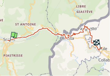
![](/images/other/stat-length.png)
![Tocht Stappen Sospel - Sospel à Airole - Photo](https://media.geolcdn.com/t/1900/400/622c1387-f27c-4930-b49d-58faf0703426.jpg&format=pjpeg&maxdim=2)
Sospel à Airole
patsure
Gebruiker
![Lengte](/images/other/stat-length.png)
![Max. hoogte](https://static1.geolcdn.com/siteimages/upload/files/1508320355ic_sort_altitude_max_24dp.png)
![Positief hoogteverschil](https://static1.geolcdn.com/siteimages/upload/files/1508320355ic_sort_den_pos_24dp.png)
![Km-Effort](/images/other/stat-length.png)
![Min. hoogte](https://static1.geolcdn.com/siteimages/upload/files/1508320355ic_sort_altitude_min_24dp.png)
![Negatief hoogteverschil](https://static1.geolcdn.com/siteimages/upload/files/1508320355ic_sort_den_neg_24dp.png)
![Boucle](https://static1.geolcdn.com/siteimages/upload/files/16400158638029165_repeat_loop_refresh_sync_direction_icon.png)
![Stappen](https://static1.geolcdn.com/sitytour/trail-icons/101.png)
4h58
Moeilijkheid : Medium
![Scan deze QR-code om de tocht te openen in de SityTrail-applicatie](https://capi.geolives.com/qq0zvz2zws4bq2lad0pu/sitytour/trails/3658343/qr.png?size=200)
Gratisgps-wandelapplicatie
Over ons
Tocht Stappen van 16,1 km beschikbaar op Provence-Alpes-Côte d'Azur, Alpes-Maritimes, Sospel. Deze tocht wordt voorgesteld door patsure.
Beschrijving
Rando faisable avec le train des Merveilles 7h20.
Démarre de Sospel à 8h40 après être passé à la boulangerie, passage à Olivetta chez Remo avant 12h pour acheter de l'huile. Quitter à 12h30, passage à Fanghetto vers 3h. arrivée à Airole vers 16h30 pour un Cioccolatte au bar Happy Days sur la place de l'église.
Train de retour par Vintimille à 17h03.
Plaatsbepaling
Opmerkingen
Wandeltochten in de omgeving
![Tocht Te voet Sospel - Circuit du Cuore - Photo](https://media.geolcdn.com/t/375/260/874c44c6-9655-4f1b-91f3-823e79b13bac.jpeg&format=jpg&maxdim=2)
![Te voet Te voet](https://static1.geolcdn.com/sitytour/trail-icons/100.png)
Te voet
![](/images/other/stat-length.png)
![](https://static1.geolcdn.com/siteimages/upload/files/16400158638029165_repeat_loop_refresh_sync_direction_icon.png)
![Tocht Te voet Sospel - Tour du mont Grazian - Photo](https://media.geolcdn.com/t/375/260/1da10739-2e7a-4ef9-ac53-576dd44be28a.jpeg&format=jpg&maxdim=2)
![Te voet Te voet](https://static1.geolcdn.com/sitytour/trail-icons/100.png)
Te voet
![](/images/other/stat-length.png)
![](https://static1.geolcdn.com/siteimages/upload/files/16400158638029165_repeat_loop_refresh_sync_direction_icon.png)
![Tocht Te voet Sospel - Boucle du mont Agaisen - Photo](https://media.geolcdn.com/t/375/260/8adecf07-fe22-4434-84e5-fdafc3720390.jpeg&format=jpg&maxdim=2)
![Te voet Te voet](https://static1.geolcdn.com/sitytour/trail-icons/100.png)
Te voet
![](/images/other/stat-length.png)
![](https://static1.geolcdn.com/siteimages/upload/files/16400158638029165_repeat_loop_refresh_sync_direction_icon.png)
![Tocht Te voet Ventimiglia - AM0 - ALPI MARE 0 - Photo](https://media.geolcdn.com/t/375/260/6cc1eb13-113d-4d04-9dbb-12c9f2aaa749.jpeg&format=jpg&maxdim=2)
![Te voet Te voet](https://static1.geolcdn.com/sitytour/trail-icons/100.png)
Te voet
![](/images/other/stat-length.png)
![](https://static1.geolcdn.com/siteimages/upload/files/16400158638029165_repeat_loop_refresh_sync_direction_icon.png)
![Tocht Stappen Sospel - Sospel - Le Mont Agaisen - Photo](https://media.geolcdn.com/t/375/260/ext.jpg?maxdim=2&url=https%3A%2F%2Fservices.sitytrail.com%2FGeolivesWS%2FDownloadMedia.ashx%3FTrailID%3D435408%26Media%3Dfix__20150616122103.jpg)
![Stappen Stappen](https://static1.geolcdn.com/sitytour/trail-icons/101.png)
Stappen
![](/images/other/stat-length.png)
![](https://static1.geolcdn.com/siteimages/upload/files/16400158638029165_repeat_loop_refresh_sync_direction_icon.png)
![Tocht Stappen Sospel - 06 - Moyen Pays - 46. Tour du Mont Grazian - Photo](https://media.geolcdn.com/t/375/260/ext.jpg?maxdim=2&url=https%3A%2F%2Fstatic1.geolcdn.com%2Fsiteimages%2Fupload%2Ffiles%2F1553511878bg_sport_marche.png)
![Stappen Stappen](https://static1.geolcdn.com/sitytour/trail-icons/101.png)
Stappen
![](/images/other/stat-length.png)
![](https://static1.geolcdn.com/siteimages/upload/files/16400158638029165_repeat_loop_refresh_sync_direction_icon.png)
![Tocht Stappen Castillon - Castillon : Mt Ours - Photo](https://media.geolcdn.com/t/375/260/18e786f6-adf4-41b3-a67d-83ef4f1666ea.jpg&format=jpg&maxdim=2)
![Stappen Stappen](https://static1.geolcdn.com/sitytour/trail-icons/101.png)
Stappen
![](/images/other/stat-length.png)
![](https://static1.geolcdn.com/siteimages/upload/files/16400158638029165_repeat_loop_refresh_sync_direction_icon.png)
![Tocht Stappen Castillon - Du col de Castillon pour la crête du Mt Razet - Photo](https://media.geolcdn.com/t/375/260/e81c49f2-8db0-4c72-8c27-b5f2f0f4c321.jpg&format=jpg&maxdim=2)
![Stappen Stappen](https://static1.geolcdn.com/sitytour/trail-icons/101.png)
Stappen
![](/images/other/stat-length.png)
![](https://static1.geolcdn.com/siteimages/upload/files/16400158638029165_repeat_loop_refresh_sync_direction_icon.png)
![Tocht Stappen Sospel - Cime de Penas - Photo](https://media.geolcdn.com/t/375/260/5d598a7f-6c92-4be0-8e5c-3f4abdadf3be.jpg&format=jpg&maxdim=2)
![Stappen Stappen](https://static1.geolcdn.com/sitytour/trail-icons/101.png)
Stappen
![](/images/other/stat-length.png)
![](https://static1.geolcdn.com/siteimages/upload/files/16400158638029165_repeat_loop_refresh_sync_direction_icon.png)