![](/images/other/stat-length.png)
![Tocht Te voet Deux-Grosnes - Randonnée du 08/05/2023 à 09:50 - Photo](https://media.geolcdn.com/t/1900/400/978af0e4-ad1c-45b0-93e7-2cfd5726f277.jpeg&format=pjpeg&maxdim=2)
Randonnée du 08/05/2023 à 09:50
Thomasdanielle
Gebruiker
![Lengte](/images/other/stat-length.png)
![Max. hoogte](https://static1.geolcdn.com/siteimages/upload/files/1508320355ic_sort_altitude_max_24dp.png)
![Positief hoogteverschil](https://static1.geolcdn.com/siteimages/upload/files/1508320355ic_sort_den_pos_24dp.png)
![Km-Effort](/images/other/stat-length.png)
![Min. hoogte](https://static1.geolcdn.com/siteimages/upload/files/1508320355ic_sort_altitude_min_24dp.png)
![Negatief hoogteverschil](https://static1.geolcdn.com/siteimages/upload/files/1508320355ic_sort_den_neg_24dp.png)
![Boucle](https://static1.geolcdn.com/siteimages/upload/files/16400158638029165_repeat_loop_refresh_sync_direction_icon.png)
![Te voet](https://static1.geolcdn.com/sitytour/trail-icons/100.png)
5h50
Moeilijkheid : Medium
![Scan deze QR-code om de tocht te openen in de SityTrail-applicatie](https://capi.geolives.com/qq0zvz2zws4bq2lad0pu/sitytour/trails/3652241/qr.png?size=200)
Gratisgps-wandelapplicatie
Over ons
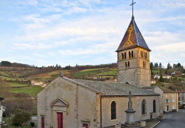
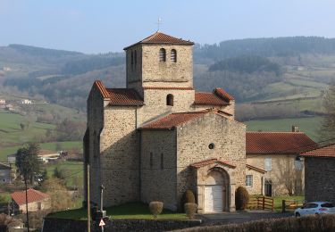
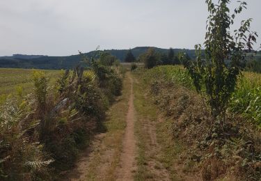
Tocht Te voet van 17,7 km beschikbaar op Auvergne-Rhône-Alpes, Rhône, Deux-Grosnes. Deze tocht wordt voorgesteld door Thomasdanielle.
Beschrijving
D/A départ de la la Salle communale.
Randonnée village du 8 mai 2023, belle marche mais difficile pour randonneurs débutants.
Organisée par Animations Loisirs et rencontres "Les Genets"
Les 2 ravitaillements au cours de la randonnée étaient copieux et bons (RAS), café offert à l'arrivée le matin soupe à l'oignon au retour.
Je recommande cette marche du village, il ne faut pas hésiter à la faire.
Plaatsbepaling
Opmerkingen
Wandeltochten in de omgeving
![Tocht Stappen Deux-Grosnes - Circuit de Saint-Jacques des Arrêts - Photo](https://media.geolcdn.com/t/375/260/ext.jpg?maxdim=2&url=https%3A%2F%2Fservices.sitytrail.com%2FGeolivesWS%2FDownloadMedia.ashx%3FTrailID%3D112082%26Media%3D9805_3.jpg)
![Stappen Stappen](https://static1.geolcdn.com/sitytour/trail-icons/101.png)
Stappen
![](/images/other/stat-length.png)
![](https://static1.geolcdn.com/siteimages/upload/files/16400158638029165_repeat_loop_refresh_sync_direction_icon.png)
![Tocht Stappen Deux-Grosnes - Ouroux - Photo](https://media.geolcdn.com/t/375/260/8cef6e4d-d107-4e31-8a02-a874193353f3.jpg&format=jpg&maxdim=2)
![Stappen Stappen](https://static1.geolcdn.com/sitytour/trail-icons/101.png)
Stappen
![](/images/other/stat-length.png)
![](https://static1.geolcdn.com/siteimages/upload/files/16400158638029165_repeat_loop_refresh_sync_direction_icon.png)
![Tocht Stappen Vauxrenard - Itinérant Beaujolais rouge étape 6 Foretal - Macon gare TGV - Photo](https://media.geolcdn.com/t/375/260/413cab1b-506e-4c3e-962c-5987ea1a88f6.jpg&format=jpg&maxdim=2)
![Stappen Stappen](https://static1.geolcdn.com/sitytour/trail-icons/101.png)
Stappen
![](/images/other/stat-length.png)
![](https://static1.geolcdn.com/siteimages/upload/files/16400158638029165_repeat_loop_refresh_sync_direction_icon.png)
![Tocht Stappen Deux-Grosnes - Saint-Jacques-des-Arrêts (19 km - D. 630 m) - Photo](https://media.geolcdn.com/t/375/260/6c995322-fe22-4d23-98d4-80cc84a5e95b.jpg&format=jpg&maxdim=2)
![Stappen Stappen](https://static1.geolcdn.com/sitytour/trail-icons/101.png)
Stappen
![](/images/other/stat-length.png)
![](https://static1.geolcdn.com/siteimages/upload/files/16400158638029165_repeat_loop_refresh_sync_direction_icon.png)
![Tocht Te voet Deux-Grosnes - Circuit des Sapins - Photo](https://media.geolcdn.com/t/375/260/358eb254-a341-41ca-ac19-9b6a7242af0e.jpeg&format=jpg&maxdim=2)
![Te voet Te voet](https://static1.geolcdn.com/sitytour/trail-icons/100.png)
Te voet
![](/images/other/stat-length.png)
![](https://static1.geolcdn.com/siteimages/upload/files/16400158638029165_repeat_loop_refresh_sync_direction_icon.png)
![Tocht Te voet Deux-Grosnes - Circuit du Bois du Thym - Photo](https://media.geolcdn.com/t/375/260/2b58ccdf-aad2-401f-88d2-df05495be483.jpeg&format=jpg&maxdim=2)
![Te voet Te voet](https://static1.geolcdn.com/sitytour/trail-icons/100.png)
Te voet
![](/images/other/stat-length.png)
![](https://static1.geolcdn.com/siteimages/upload/files/16400158638029165_repeat_loop_refresh_sync_direction_icon.png)
![Tocht Stappen Cenves - cenves la madone - Photo](https://media.geolcdn.com/t/375/260/a381df5f-0cf9-4146-a04a-b176620d4d7d.jpg&format=jpg&maxdim=2)
![Stappen Stappen](https://static1.geolcdn.com/sitytour/trail-icons/101.png)
Stappen
![](/images/other/stat-length.png)
![](https://static1.geolcdn.com/siteimages/upload/files/16400158638029165_repeat_loop_refresh_sync_direction_icon.png)
![Tocht Stappen Cenves - Cenves](https://media.geolcdn.com/t/375/260/e37d4c40-86a6-4702-8656-51d1279bf78a.jpeg&format=jpg&maxdim=2)
![Stappen Stappen](https://static1.geolcdn.com/sitytour/trail-icons/101.png)
Stappen
![](/images/other/stat-length.png)
![](https://static1.geolcdn.com/siteimages/upload/files/16400158638029165_repeat_loop_refresh_sync_direction_icon.png)
![Tocht Lopen Deux-Grosnes - jour 2 CAP Jeanot - Photo](https://media.geolcdn.com/t/375/260/93d411c4-dc79-4569-9ea1-f30f8dbdd64b.jpg&format=jpg&maxdim=2)
![Lopen Lopen](https://static1.geolcdn.com/sitytour/trail-icons/103.png)
Lopen
![](/images/other/stat-length.png)
![](https://static1.geolcdn.com/siteimages/upload/files/16400158638029165_repeat_loop_refresh_sync_direction_icon.png)