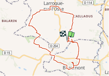
![](/images/other/stat-length.png)
![Tocht Stappen Larroque-sur-l'Osse - LRP-32002 PR1 Le Péto - Photo](https://media.geolcdn.com/t/1900/400/ext.pjpeg?maxdim=2&url=https%3A%2F%2Fstatic1.geolcdn.com%2Fsiteimages%2Fupload%2Ffiles%2F1553511878bg_sport_marche.png)
LRP-32002 PR1 Le Péto
Polo-31
Gebruiker
![Lengte](/images/other/stat-length.png)
Lengte
11,6 km
![Max. hoogte](https://static1.geolcdn.com/siteimages/upload/files/1508320355ic_sort_altitude_max_24dp.png)
Max. hoogte
162 m
![Positief hoogteverschil](https://static1.geolcdn.com/siteimages/upload/files/1508320355ic_sort_den_pos_24dp.png)
Positief hoogteverschil
213 m
![Km-Effort](/images/other/stat-length.png)
Km-Effort
14,5 km
![Min. hoogte](https://static1.geolcdn.com/siteimages/upload/files/1508320355ic_sort_altitude_min_24dp.png)
Min. hoogte
91 m
![Negatief hoogteverschil](https://static1.geolcdn.com/siteimages/upload/files/1508320355ic_sort_den_neg_24dp.png)
Negatief hoogteverschil
215 m
![Boucle](https://static1.geolcdn.com/siteimages/upload/files/16400158638029165_repeat_loop_refresh_sync_direction_icon.png)
Boucle
Ja
Datum van aanmaak :
2014-12-10 00:00:00.0
Laatste wijziging :
2014-12-10 00:00:00.0
![Stappen](https://static1.geolcdn.com/sitytour/trail-icons/101.png)
3h06
Moeilijkheid : Gemakkelijk
![Scan deze QR-code om de tocht te openen in de SityTrail-applicatie](https://capi.geolives.com/qq0zvz2zws4bq2lad0pu/sitytour/trails/364995/qr.png?size=200)
Gratisgps-wandelapplicatie
Over ons
Tocht Stappen van 11,6 km beschikbaar op Occitanië, Gers, Larroque-sur-l'Osse. Deze tocht wordt voorgesteld door Polo-31.
Beschrijving
Les Randos de Polo : Départ du domaine de Péto. Suivre le circuit PR1 qui démarre dans la propriété du Péto (Très bon Armagnac).
Plaatsbepaling
Land:
France
Regio :
Occitanië
Departement/Provincie :
Gers
Gemeente :
Larroque-sur-l'Osse
Locatie:
Unknown
Vertrek:(Dec)
Vertrek:(UTM)
281947 ; 4870698 (31T) N.
Opmerkingen
Wandeltochten in de omgeving
![Tocht Elektrische fiets Montréal - 04-06-19 - Photo](https://media.geolcdn.com/t/375/260/823fbf2d-918d-4557-a071-da280458074a.jpg&format=jpg&maxdim=2)
![Elektrische fiets Elektrische fiets](https://static1.geolcdn.com/sitytour/trail-icons/205.png)
![Tocht Fiets Montréal - Montréal - Fourcès - Larressingle - Photo](https://media.geolcdn.com/t/375/260/83486d4f-6345-4995-a2c8-47da1265dffe.jpg&format=jpg&maxdim=2)
![Fiets Fiets](https://static1.geolcdn.com/sitytour/trail-icons/200.png)
Montréal - Fourcès - Larressingle
Fiets
Gemakkelijk
Montréal,
Occitanië,
Gers,
France
![](/images/other/stat-length.png)
42 km | 49 km-effort
2h 47min
![](https://static1.geolcdn.com/siteimages/upload/files/16400158638029165_repeat_loop_refresh_sync_direction_icon.png)
Ja
![Tocht Stappen Larressingle - StJ-J36-Condom-Laboge - Photo](https://media.geolcdn.com/t/375/260/ext.jpg?maxdim=2&url=https%3A%2F%2Fstatic1.geolcdn.com%2Fsiteimages%2Fupload%2Ffiles%2F1553511878bg_sport_marche.png)
![Stappen Stappen](https://static1.geolcdn.com/sitytour/trail-icons/101.png)
StJ-J36-Condom-Laboge
Stappen
Zeer moeilijk
Larressingle,
Occitanië,
Gers,
France
![](/images/other/stat-length.png)
22 km | 27 km-effort
5h 45min
![](https://static1.geolcdn.com/siteimages/upload/files/16400158638029165_repeat_loop_refresh_sync_direction_icon.png)
Neen
![Tocht Stappen Larressingle - larressingle.Eauze - Photo](https://media.geolcdn.com/t/375/260/ext.jpg?maxdim=2&url=https%3A%2F%2Fstatic1.geolcdn.com%2Fsiteimages%2Fupload%2Ffiles%2F1553511878bg_sport_marche.png)
![Stappen Stappen](https://static1.geolcdn.com/sitytour/trail-icons/101.png)
larressingle.Eauze
Stappen
Heel gemakkelijk
Larressingle,
Occitanië,
Gers,
France
![](/images/other/stat-length.png)
27 km | 33 km-effort
5h 47min
![](https://static1.geolcdn.com/siteimages/upload/files/16400158638029165_repeat_loop_refresh_sync_direction_icon.png)
Neen
![Tocht Stappen Larressingle - OR-6946156--Larressingle:larressingle-eauze-5 - Photo](https://media.geolcdn.com/t/375/260/ext.jpg?maxdim=2&url=https%3A%2F%2Fstatic1.geolcdn.com%2Fsiteimages%2Fupload%2Ffiles%2F1553511878bg_sport_marche.png)
![Stappen Stappen](https://static1.geolcdn.com/sitytour/trail-icons/101.png)
OR-6946156--Larressingle:larressingle-eauze-5
Stappen
Heel gemakkelijk
Larressingle,
Occitanië,
Gers,
France
![](/images/other/stat-length.png)
27 km | 33 km-effort
7h 2min
![](https://static1.geolcdn.com/siteimages/upload/files/16400158638029165_repeat_loop_refresh_sync_direction_icon.png)
Neen
![Tocht Stappen Larressingle - Compostelle 24 - Larressingle -> Eauze - Photo](https://media.geolcdn.com/t/375/260/ext.jpg?maxdim=2&url=https%3A%2F%2Fstatic1.geolcdn.com%2Fsiteimages%2Fupload%2Ffiles%2F1553511878bg_sport_marche.png)
![Stappen Stappen](https://static1.geolcdn.com/sitytour/trail-icons/101.png)
Compostelle 24 - Larressingle -> Eauze
Stappen
Medium
(1)
Larressingle,
Occitanië,
Gers,
France
![](/images/other/stat-length.png)
29 km | 35 km-effort
7h 30min
![](https://static1.geolcdn.com/siteimages/upload/files/16400158638029165_repeat_loop_refresh_sync_direction_icon.png)
Neen
![Tocht Stappen Condom - LRP-32001 PR1 Les Chalets - Photo](https://media.geolcdn.com/t/375/260/ext.jpg?maxdim=2&url=https%3A%2F%2Fstatic1.geolcdn.com%2Fsiteimages%2Fupload%2Ffiles%2F1553511878bg_sport_marche.png)
![Stappen Stappen](https://static1.geolcdn.com/sitytour/trail-icons/101.png)
LRP-32001 PR1 Les Chalets
Stappen
Medium
Condom,
Occitanië,
Gers,
France
![](/images/other/stat-length.png)
16,3 km | 20 km-effort
4h 23min
![](https://static1.geolcdn.com/siteimages/upload/files/16400158638029165_repeat_loop_refresh_sync_direction_icon.png)
Ja
![Tocht Stappen Fourcès - De Fources à Condom - Photo](https://media.geolcdn.com/t/375/260/ext.jpg?maxdim=2&url=https%3A%2F%2Fstatic1.geolcdn.com%2Fsiteimages%2Fupload%2Ffiles%2F1553511878bg_sport_marche.png)
![Stappen Stappen](https://static1.geolcdn.com/sitytour/trail-icons/101.png)
De Fources à Condom
Stappen
Moeilijk
Fourcès,
Occitanië,
Gers,
France
![](/images/other/stat-length.png)
21 km | 26 km-effort
5h 0min
![](https://static1.geolcdn.com/siteimages/upload/files/16400158638029165_repeat_loop_refresh_sync_direction_icon.png)
Neen
![Tocht Stappen Larressingle - larressing - Photo](https://media.geolcdn.com/t/375/260/ext.jpg?maxdim=2&url=https%3A%2F%2Fstatic1.geolcdn.com%2Fsiteimages%2Fupload%2Ffiles%2F1553511878bg_sport_marche.png)
![Stappen Stappen](https://static1.geolcdn.com/sitytour/trail-icons/101.png)
larressing
Stappen
Gemakkelijk
Larressingle,
Occitanië,
Gers,
France
![](/images/other/stat-length.png)
4,5 km | 5,4 km-effort
1h 51min
![](https://static1.geolcdn.com/siteimages/upload/files/16400158638029165_repeat_loop_refresh_sync_direction_icon.png)
Neen