![](/images/other/stat-length.png)
![Tocht Stappen Propières - Propières (18 km - D. 642 m) - Photo](https://media.geolcdn.com/t/1900/400/ext.pjpeg?maxdim=2&url=https%3A%2F%2Fstatic1.geolcdn.com%2Fsiteimages%2Fupload%2Ffiles%2F1553511878bg_sport_marche.png)
Propières (18 km - D. 642 m)
Thomasdanielle
Gebruiker
![Lengte](/images/other/stat-length.png)
Lengte
18,2 km
![Max. hoogte](https://static1.geolcdn.com/siteimages/upload/files/1508320355ic_sort_altitude_max_24dp.png)
Max. hoogte
959 m
![Positief hoogteverschil](https://static1.geolcdn.com/siteimages/upload/files/1508320355ic_sort_den_pos_24dp.png)
Positief hoogteverschil
642 m
![Km-Effort](/images/other/stat-length.png)
Km-Effort
27 km
![Min. hoogte](https://static1.geolcdn.com/siteimages/upload/files/1508320355ic_sort_altitude_min_24dp.png)
Min. hoogte
547 m
![Negatief hoogteverschil](https://static1.geolcdn.com/siteimages/upload/files/1508320355ic_sort_den_neg_24dp.png)
Negatief hoogteverschil
641 m
![Boucle](https://static1.geolcdn.com/siteimages/upload/files/16400158638029165_repeat_loop_refresh_sync_direction_icon.png)
Boucle
Ja
Datum van aanmaak :
2023-05-04 07:35:49.0
Laatste wijziging :
2023-05-05 07:40:00.466
![Stappen](https://static1.geolcdn.com/sitytour/trail-icons/101.png)
6h04
Moeilijkheid : Zeer moeilijk
![Scan deze QR-code om de tocht te openen in de SityTrail-applicatie](https://capi.geolives.com/qq0zvz2zws4bq2lad0pu/sitytour/trails/3647101/qr.png?size=200)
Gratisgps-wandelapplicatie
Over ons
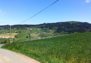
Tocht Stappen van 18,2 km beschikbaar op Auvergne-Rhône-Alpes, Rhône, Propières. Deze tocht wordt voorgesteld door Thomasdanielle.
Beschrijving
D/A : parking de la Poste
Suivre la flèche "noire" pratiquement tout au long de la randonnée en suivant le tracé sur le téléphone.
Plaatsbepaling
Land:
France
Regio :
Auvergne-Rhône-Alpes
Departement/Provincie :
Rhône
Gemeente :
Propières
Locatie:
Unknown
Vertrek:(Dec)
Vertrek:(UTM)
610927 ; 5116272 (31T) N.
Opmerkingen
Wandeltochten in de omgeving
![Tocht Stappen Saint-Germain-la-Montagne - Circuit du Tourniquet - Saint Germain la Montagne - Photo](https://media.geolcdn.com/t/375/260/ext.jpg?maxdim=2&url=https%3A%2F%2Fservices.sitytrail.com%2FGeolivesWS%2FDownloadMedia.ashx%3FTrailID%3D107382%26Media%3D12284_6.jpg)
![Stappen Stappen](https://static1.geolcdn.com/sitytour/trail-icons/101.png)
Circuit du Tourniquet - Saint Germain la Montagne
Stappen
Moeilijk
(1)
Saint-Germain-la-Montagne,
Auvergne-Rhône-Alpes,
Loire,
France
![](/images/other/stat-length.png)
15 km | 22 km-effort
4h 0min
![](https://static1.geolcdn.com/siteimages/upload/files/16400158638029165_repeat_loop_refresh_sync_direction_icon.png)
Ja
![Tocht Te voet Propières - Circuit de Propières n°3 - 15 km - Noir - Photo](https://media.geolcdn.com/t/375/260/8e2640e6-7b75-4b6e-a5e9-fe114f5074bb.jpeg&format=jpg&maxdim=2)
![Te voet Te voet](https://static1.geolcdn.com/sitytour/trail-icons/100.png)
Circuit de Propières n°3 - 15 km - Noir
Te voet
Medium
Propières,
Auvergne-Rhône-Alpes,
Rhône,
France
![](/images/other/stat-length.png)
14,3 km | 21 km-effort
4h 46min
![](https://static1.geolcdn.com/siteimages/upload/files/16400158638029165_repeat_loop_refresh_sync_direction_icon.png)
Ja
![Tocht Te voet Saint-Clément-de-Vers - Circuit Bleu - Photo](https://media.geolcdn.com/t/375/260/7f9adbe1-6cfb-42fe-b291-e5722845c792.jpeg&format=jpg&maxdim=2)
![Te voet Te voet](https://static1.geolcdn.com/sitytour/trail-icons/100.png)
Circuit Bleu
Te voet
Medium
Saint-Clément-de-Vers,
Auvergne-Rhône-Alpes,
Rhône,
France
![](/images/other/stat-length.png)
16,1 km | 23 km-effort
5h 17min
![](https://static1.geolcdn.com/siteimages/upload/files/16400158638029165_repeat_loop_refresh_sync_direction_icon.png)
Ja
![Tocht Te voet Propières - Circuit du Mont Saint-Rigaud 12 km - Photo](https://media.geolcdn.com/t/375/260/8fe17dfa-2ab9-4de6-a590-f911d28759c5.jpeg&format=jpg&maxdim=2)
![Te voet Te voet](https://static1.geolcdn.com/sitytour/trail-icons/100.png)
Circuit du Mont Saint-Rigaud 12 km
Te voet
Gemakkelijk
Propières,
Auvergne-Rhône-Alpes,
Rhône,
France
![](/images/other/stat-length.png)
11,8 km | 18,3 km-effort
4h 9min
![](https://static1.geolcdn.com/siteimages/upload/files/16400158638029165_repeat_loop_refresh_sync_direction_icon.png)
Ja
![Tocht Stappen Saint-Igny-de-Vers - Ajoux (69) - Photo](https://media.geolcdn.com/t/375/260/ext.jpg?maxdim=2&url=https%3A%2F%2Fservices.sitytrail.com%2FGeolivesWS%2FDownloadMedia.ashx%3FTrailID%3D853671%26Media%3D20170821120904.jpg)
![Stappen Stappen](https://static1.geolcdn.com/sitytour/trail-icons/101.png)
Ajoux (69)
Stappen
Heel gemakkelijk
Saint-Igny-de-Vers,
Auvergne-Rhône-Alpes,
Rhône,
France
![](/images/other/stat-length.png)
16,6 km | 23 km-effort
4h 55min
![](https://static1.geolcdn.com/siteimages/upload/files/16400158638029165_repeat_loop_refresh_sync_direction_icon.png)
Ja
![Tocht Stappen Saint-Igny-de-Vers - Ajoux (69) - Photo](https://media.geolcdn.com/t/375/260/ext.jpg?maxdim=2&url=https%3A%2F%2Fservices.sitytrail.com%2FGeolivesWS%2FDownloadMedia.ashx%3FTrailID%3D814594%26Media%3D20170821120904.jpg)
![Stappen Stappen](https://static1.geolcdn.com/sitytour/trail-icons/101.png)
Ajoux (69)
Stappen
Gemakkelijk
Saint-Igny-de-Vers,
Auvergne-Rhône-Alpes,
Rhône,
France
![](/images/other/stat-length.png)
15,8 km | 23 km-effort
4h 43min
![](https://static1.geolcdn.com/siteimages/upload/files/16400158638029165_repeat_loop_refresh_sync_direction_icon.png)
Ja
![Tocht Mountainbike Saint-Germain-la-Montagne - VTT sportif à travers bois - Saint Germain la Montagne - Photo](https://media.geolcdn.com/t/375/260/ext.jpg?maxdim=2&url=https%3A%2F%2Fservices.sitytrail.com%2FGeolivesWS%2FDownloadMedia.ashx%3FTrailID%3D318003%26Media%3D17457_6.jpg)
![Mountainbike Mountainbike](https://static1.geolcdn.com/sitytour/trail-icons/202.png)
VTT sportif à travers bois - Saint Germain la Montagne
Mountainbike
Moeilijk
Saint-Germain-la-Montagne,
Auvergne-Rhône-Alpes,
Loire,
France
![](/images/other/stat-length.png)
32 km | 47 km-effort
3h 0min
![](https://static1.geolcdn.com/siteimages/upload/files/16400158638029165_repeat_loop_refresh_sync_direction_icon.png)
Ja
![Tocht Stappen Propières - Circuit de Propières - Photo](https://media.geolcdn.com/t/375/260/ext.jpg?maxdim=2&url=https%3A%2F%2Fservices.sitytrail.com%2FGeolivesWS%2FDownloadMedia.ashx%3FTrailID%3D172258%26Media%3D13567_3.jpg)
![Stappen Stappen](https://static1.geolcdn.com/sitytour/trail-icons/101.png)
Circuit de Propières
Stappen
Moeilijk
Propières,
Auvergne-Rhône-Alpes,
Rhône,
France
![](/images/other/stat-length.png)
14,3 km | 21 km-effort
5h 0min
![](https://static1.geolcdn.com/siteimages/upload/files/16400158638029165_repeat_loop_refresh_sync_direction_icon.png)
Ja
![Tocht Mountainbike Belleroche - Marche de Belleroche - Photo](https://media.geolcdn.com/t/375/260/ext.jpg?maxdim=2&url=https%3A%2F%2Fservices.sitytrail.com%2FGeolivesWS%2FDownloadMedia.ashx%3FTrailID%3D127260%26Media%3D20120513142447.jpg)
![Mountainbike Mountainbike](https://static1.geolcdn.com/sitytour/trail-icons/202.png)
Marche de Belleroche
Mountainbike
Moeilijk
Belleroche,
Auvergne-Rhône-Alpes,
Loire,
France
![](/images/other/stat-length.png)
33 km | 48 km-effort
2h 59min
![](https://static1.geolcdn.com/siteimages/upload/files/16400158638029165_repeat_loop_refresh_sync_direction_icon.png)
Ja