![](/images/other/stat-length.png)
![Tocht Hybride fiets Montgeron - vélo port aux cerises, parc et jardin Jacky - Photo](https://media.geolcdn.com/t/1900/400/ext.pjpeg?maxdim=2&url=https%3A%2F%2Fstatic1.geolcdn.com%2Fsiteimages%2Fupload%2Ffiles%2F1524743154velo.jpg)
vélo port aux cerises, parc et jardin Jacky
Catherine de Brunoy
Gebruiker
![Lengte](/images/other/stat-length.png)
Lengte
29 km
![Max. hoogte](https://static1.geolcdn.com/siteimages/upload/files/1508320355ic_sort_altitude_max_24dp.png)
Max. hoogte
95 m
![Positief hoogteverschil](https://static1.geolcdn.com/siteimages/upload/files/1508320355ic_sort_den_pos_24dp.png)
Positief hoogteverschil
239 m
![Km-Effort](/images/other/stat-length.png)
Km-Effort
32 km
![Min. hoogte](https://static1.geolcdn.com/siteimages/upload/files/1508320355ic_sort_altitude_min_24dp.png)
Min. hoogte
28 m
![Negatief hoogteverschil](https://static1.geolcdn.com/siteimages/upload/files/1508320355ic_sort_den_neg_24dp.png)
Negatief hoogteverschil
259 m
![Boucle](https://static1.geolcdn.com/siteimages/upload/files/16400158638029165_repeat_loop_refresh_sync_direction_icon.png)
Boucle
Neen
Datum van aanmaak :
2023-05-02 08:44:55.342
Laatste wijziging :
2023-05-02 12:04:21.97
![Hybride fiets](https://static1.geolcdn.com/sitytour/trail-icons/203.png)
2h15
Moeilijkheid : Moeilijk
![Scan deze QR-code om de tocht te openen in de SityTrail-applicatie](https://capi.geolives.com/qq0zvz2zws4bq2lad0pu/sitytour/trails/3643934/qr.png?size=200)
Gratisgps-wandelapplicatie
Over ons
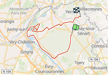
Tocht Hybride fiets van 29 km beschikbaar op Île-de-France, Essonne, Montgeron. Deze tocht wordt voorgesteld door Catherine de Brunoy.
Beschrijving
Brunoy - forêt de Senart - port aux cerises - Draveil cité Paris jardin.
retour par Montgeron essayer de modifier le retour par forêt...
Plaatsbepaling
Land:
France
Regio :
Île-de-France
Departement/Provincie :
Essonne
Gemeente :
Montgeron
Locatie:
Unknown
Vertrek:(Dec)
Vertrek:(UTM)
462406 ; 5392307 (31U) N.
Opmerkingen
Wandeltochten in de omgeving
![Tocht Te voet Villecresnes - L 20 boucle golf villecresnes et ancienne voie de chemin de fer - Photo](https://media.geolcdn.com/t/375/260/ext.jpg?maxdim=2&url=https%3A%2F%2Fstatic1.geolcdn.com%2Fsiteimages%2Fupload%2Ffiles%2F1545311037marcheuse_200dpi.jpg)
![Te voet Te voet](https://static1.geolcdn.com/sitytour/trail-icons/100.png)
L 20 boucle golf villecresnes et ancienne voie de chemin de fer
Te voet
Heel gemakkelijk
(6)
Villecresnes,
Île-de-France,
Val-de-Marne,
France
![](/images/other/stat-length.png)
6,5 km | 7,7 km-effort
1h 44min
![](https://static1.geolcdn.com/siteimages/upload/files/16400158638029165_repeat_loop_refresh_sync_direction_icon.png)
Ja
![Tocht Stappen Boussy-Saint-Antoine - GRP CV-IDF 04 - Photo](https://media.geolcdn.com/t/375/260/9a88b6b6-acb4-4798-9224-ae0478acaf21.jpg&format=jpg&maxdim=2)
![Stappen Stappen](https://static1.geolcdn.com/sitytour/trail-icons/101.png)
GRP CV-IDF 04
Stappen
Moeilijk
(1)
Boussy-Saint-Antoine,
Île-de-France,
Essonne,
France
![](/images/other/stat-length.png)
16,8 km | 18,6 km-effort
4h 13min
![](https://static1.geolcdn.com/siteimages/upload/files/16400158638029165_repeat_loop_refresh_sync_direction_icon.png)
Neen
![Tocht Stappen Mandres-les-Roses - J 26 Mandres, Boussy , Brunoy le chemin des fresques - Photo](https://media.geolcdn.com/t/375/260/a7099e05-5a69-431c-83ab-49f9701f5dd5.jpg&format=jpg&maxdim=2)
![Stappen Stappen](https://static1.geolcdn.com/sitytour/trail-icons/101.png)
J 26 Mandres, Boussy , Brunoy le chemin des fresques
Stappen
Medium
(2)
Mandres-les-Roses,
Île-de-France,
Val-de-Marne,
France
![](/images/other/stat-length.png)
12,2 km | 13,8 km-effort
3h 7min
![](https://static1.geolcdn.com/siteimages/upload/files/16400158638029165_repeat_loop_refresh_sync_direction_icon.png)
Ja
![Tocht Te voet Tigery - L 23 Lieusaint, ruisseau des Heauldres, canal d'Ormoy - Photo](https://media.geolcdn.com/t/375/260/f8075a31-4ce3-4b81-a6e4-b6a4b3920940.jpg&format=jpg&maxdim=2)
![Te voet Te voet](https://static1.geolcdn.com/sitytour/trail-icons/100.png)
L 23 Lieusaint, ruisseau des Heauldres, canal d'Ormoy
Te voet
Heel gemakkelijk
(3)
Tigery,
Île-de-France,
Essonne,
France
![](/images/other/stat-length.png)
6,3 km | 6,8 km-effort
1h 32min
![](https://static1.geolcdn.com/siteimages/upload/files/16400158638029165_repeat_loop_refresh_sync_direction_icon.png)
Ja
![Tocht Stappen Tigery - Ru des Hauldres - Photo](https://media.geolcdn.com/t/375/260/ext.jpg?maxdim=2&url=https%3A%2F%2Fstatic1.geolcdn.com%2Fsiteimages%2Fupload%2Ffiles%2F1553511878bg_sport_marche.png)
![Stappen Stappen](https://static1.geolcdn.com/sitytour/trail-icons/101.png)
Ru des Hauldres
Stappen
Medium
(1)
Tigery,
Île-de-France,
Essonne,
France
![](/images/other/stat-length.png)
8,7 km | 9,3 km-effort
2h 7min
![](https://static1.geolcdn.com/siteimages/upload/files/16400158638029165_repeat_loop_refresh_sync_direction_icon.png)
Ja
![Tocht Te voet Brunoy - L 39 Brunoy, les bords de l'Yerres - Photo](https://media.geolcdn.com/t/375/260/ebb13649-b3e9-4bd9-9011-035537427274.jpg&format=jpg&maxdim=2)
![Te voet Te voet](https://static1.geolcdn.com/sitytour/trail-icons/100.png)
L 39 Brunoy, les bords de l'Yerres
Te voet
Heel gemakkelijk
(4)
Brunoy,
Île-de-France,
Essonne,
France
![](/images/other/stat-length.png)
5,4 km | 6,1 km-effort
1h 49min
![](https://static1.geolcdn.com/siteimages/upload/files/16400158638029165_repeat_loop_refresh_sync_direction_icon.png)
Ja
![Tocht Stappen Montgeron - J 38 Montgeron la Pelouse, forêt de Sénart - Photo](https://media.geolcdn.com/t/375/260/f009853b-b232-40f1-8161-c380b5b5f65c.jpg&format=jpg&maxdim=2)
![Stappen Stappen](https://static1.geolcdn.com/sitytour/trail-icons/101.png)
J 38 Montgeron la Pelouse, forêt de Sénart
Stappen
Moeilijk
(3)
Montgeron,
Île-de-France,
Essonne,
France
![](/images/other/stat-length.png)
12,4 km | 13,3 km-effort
3h 1min
![](https://static1.geolcdn.com/siteimages/upload/files/16400158638029165_repeat_loop_refresh_sync_direction_icon.png)
Ja
![Tocht Te voet Quincy-sous-Sénart - J 77 Tigery, Allée Royale - Photo](https://media.geolcdn.com/t/375/260/0a515c89-1783-41f2-919a-9dc7db91522b.jpg&format=jpg&maxdim=2)
![Te voet Te voet](https://static1.geolcdn.com/sitytour/trail-icons/100.png)
J 77 Tigery, Allée Royale
Te voet
Medium
(3)
Quincy-sous-Sénart,
Île-de-France,
Essonne,
France
![](/images/other/stat-length.png)
10,6 km | 12 km-effort
2h 44min
![](https://static1.geolcdn.com/siteimages/upload/files/16400158638029165_repeat_loop_refresh_sync_direction_icon.png)
Ja
![Tocht Te voet Boussy-Saint-Antoine - L 32: Boussy St Antoine l'Yerres et le Gord - Photo](https://media.geolcdn.com/t/375/260/0167f6d8-7862-4a56-9e45-6680bff9395f.jpg&format=jpg&maxdim=2)
![Te voet Te voet](https://static1.geolcdn.com/sitytour/trail-icons/100.png)
L 32: Boussy St Antoine l'Yerres et le Gord
Te voet
Heel gemakkelijk
(3)
Boussy-Saint-Antoine,
Île-de-France,
Essonne,
France
![](/images/other/stat-length.png)
6,2 km | 7,2 km-effort
1h 38min
![](https://static1.geolcdn.com/siteimages/upload/files/16400158638029165_repeat_loop_refresh_sync_direction_icon.png)
Ja