![](/images/other/stat-length.png)
![Tocht Stappen Taillet - taillet - Photo](https://media.geolcdn.com/t/1900/400/ext.pjpeg?maxdim=2&url=https%3A%2F%2Fstatic1.geolcdn.com%2Fsiteimages%2Fupload%2Ffiles%2F1553511878bg_sport_marche.png)
taillet
suresnois
Gebruiker
![Lengte](/images/other/stat-length.png)
![Max. hoogte](https://static1.geolcdn.com/siteimages/upload/files/1508320355ic_sort_altitude_max_24dp.png)
![Positief hoogteverschil](https://static1.geolcdn.com/siteimages/upload/files/1508320355ic_sort_den_pos_24dp.png)
![Km-Effort](/images/other/stat-length.png)
![Min. hoogte](https://static1.geolcdn.com/siteimages/upload/files/1508320355ic_sort_altitude_min_24dp.png)
![Negatief hoogteverschil](https://static1.geolcdn.com/siteimages/upload/files/1508320355ic_sort_den_neg_24dp.png)
![Boucle](https://static1.geolcdn.com/siteimages/upload/files/16400158638029165_repeat_loop_refresh_sync_direction_icon.png)
![Stappen](https://static1.geolcdn.com/sitytour/trail-icons/101.png)
3h31
Moeilijkheid : Moeilijk
![Scan deze QR-code om de tocht te openen in de SityTrail-applicatie](https://capi.geolives.com/qq0zvz2zws4bq2lad0pu/sitytour/trails/3637464/qr.png?size=200)
Gratisgps-wandelapplicatie
Over ons
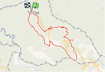
Tocht Stappen van 10,9 km beschikbaar op Occitanië, Pyrénées-Orientales, Taillet. Deze tocht wordt voorgesteld door suresnois.
Beschrijving
Départ randonnée : Au départ de la mairie de Taillet (Pyrénées-Orientale 66)
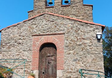
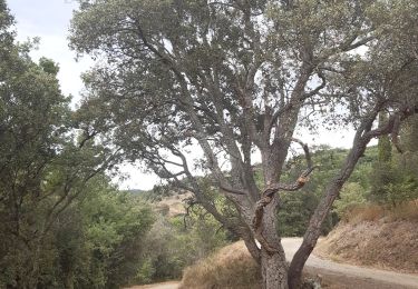
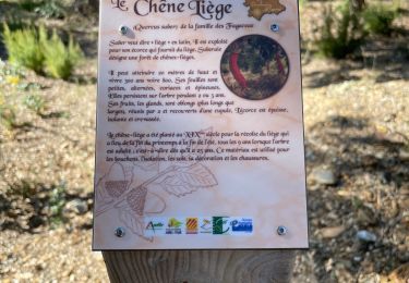
Vous partez en direction du sud par un sentier puis une piste qui traversent une forêt de chênes lièges puis vers l'est et rejoindre le hameau de Notra Senyora de la Roure avec sa petite église qui mérite vraiment une visite. Partir plein sud et un peu plus loin remonter nord/ouest jusqu'à l'élevage de lamas du Mas Font. Continuer jusqu'à Taillet et si c'est possible la visite de l'église Saint-Pierre terminera une agréable balade à éviter de faire en été.
Dist. à plat :10.7Km
Déniv:400 M
Durée:03:30 Hrs
Pour info :
Si vous partez seul prévenir un proche de votre itinéraire et de la durée,
Chaussures de marche, bâtons, GPS, carte de la randonnée avec l'itinéraire,,,
Apportez suffisamment d'eau, des en cas (fruits sec, barres de céréales,,,)
Selon les saisons : bonnet, gants, vêtements chauds, casquette, lunettes de soleil, crème solaire
Plaatsbepaling
Opmerkingen
Wandeltochten in de omgeving
![Tocht Stappen Llauro - Col de Llauro- Roc del Quers - Photo](https://media.geolcdn.com/t/375/260/ext.jpg?maxdim=2&url=https%3A%2F%2Fstatic1.geolcdn.com%2Fsiteimages%2Fupload%2Ffiles%2F1553511878bg_sport_marche.png)
![Stappen Stappen](https://static1.geolcdn.com/sitytour/trail-icons/101.png)
Stappen
![](/images/other/stat-length.png)
![](https://static1.geolcdn.com/siteimages/upload/files/16400158638029165_repeat_loop_refresh_sync_direction_icon.png)
![Tocht Stappen Montbolo - Montbolo: du col dela reducta au col de Formentera - Photo](https://media.geolcdn.com/t/375/260/754853e5-7593-4cab-8eb6-e99d080b4823.jpg&format=jpg&maxdim=2)
![Stappen Stappen](https://static1.geolcdn.com/sitytour/trail-icons/101.png)
Stappen
![](/images/other/stat-length.png)
![](https://static1.geolcdn.com/siteimages/upload/files/16400158638029165_repeat_loop_refresh_sync_direction_icon.png)
![Tocht Stappen Taillet - notre dame del roure . taillet . Notre dame del roure - Photo](https://media.geolcdn.com/t/375/260/afd37864-60c1-4a37-a110-95c3b7365479.jpg&format=jpg&maxdim=2)
![Stappen Stappen](https://static1.geolcdn.com/sitytour/trail-icons/101.png)
Stappen
![](/images/other/stat-length.png)
![](https://static1.geolcdn.com/siteimages/upload/files/16400158638029165_repeat_loop_refresh_sync_direction_icon.png)
![Tocht Stappen Reynès - taillet ( vallespir ) - Photo](https://media.geolcdn.com/t/375/260/899aa047-a757-42a8-b036-2b05db653e14.jpg&format=jpg&maxdim=2)
![Stappen Stappen](https://static1.geolcdn.com/sitytour/trail-icons/101.png)
Stappen
![](/images/other/stat-length.png)
![](https://static1.geolcdn.com/siteimages/upload/files/16400158638029165_repeat_loop_refresh_sync_direction_icon.png)
![Tocht Stappen Amélie-les-Bains-Palalda - Amélie les Bains - Roc de la Campana - Photo](https://media.geolcdn.com/t/375/260/1842026f-51ff-49df-a557-6a7ae07b89ff.jpg&format=jpg&maxdim=2)
![Stappen Stappen](https://static1.geolcdn.com/sitytour/trail-icons/101.png)
Stappen
![](/images/other/stat-length.png)
![](https://static1.geolcdn.com/siteimages/upload/files/16400158638029165_repeat_loop_refresh_sync_direction_icon.png)
![Tocht Stappen Reynès - Reynès, chemin des mas ... pas terrible - Photo](https://media.geolcdn.com/t/375/260/b3689c6c-fb16-4572-9927-bc84707dff9d.jpg&format=jpg&maxdim=2)
![Stappen Stappen](https://static1.geolcdn.com/sitytour/trail-icons/101.png)
Stappen
![](/images/other/stat-length.png)
![](https://static1.geolcdn.com/siteimages/upload/files/16400158638029165_repeat_loop_refresh_sync_direction_icon.png)
![Tocht Stappen Oms - Ils - Photo](https://media.geolcdn.com/t/375/260/445d8f7f-4337-4ef1-ba3d-c13c26daffe8.jpg&format=jpg&maxdim=2)
![Stappen Stappen](https://static1.geolcdn.com/sitytour/trail-icons/101.png)
![Tocht Stappen Reynès - Le Vila - La Serra de Taillet - Photo](https://media.geolcdn.com/t/375/260/ext.jpg?maxdim=2&url=https%3A%2F%2Fstatic1.geolcdn.com%2Fsiteimages%2Fupload%2Ffiles%2F1553511878bg_sport_marche.png)
![Stappen Stappen](https://static1.geolcdn.com/sitytour/trail-icons/101.png)
Stappen
![](/images/other/stat-length.png)
![](https://static1.geolcdn.com/siteimages/upload/files/16400158638029165_repeat_loop_refresh_sync_direction_icon.png)
![Tocht Stappen Reynès - Chapelle du Route - Photo](https://media.geolcdn.com/t/375/260/11a45522-595b-49f3-8f03-7fe95251b4bd.jpg&format=jpg&maxdim=2)
![Stappen Stappen](https://static1.geolcdn.com/sitytour/trail-icons/101.png)
Stappen
![](/images/other/stat-length.png)
![](https://static1.geolcdn.com/siteimages/upload/files/16400158638029165_repeat_loop_refresh_sync_direction_icon.png)